![]()
www.agriculture.com …Online
articles and active discussion forum on technology
Data Analysis Considerations and
Procedures for Site-Specific Crop Management
Part
1 – Understanding Mapped Data and Basic Analysis Approaches
Part
2 – Identifying Spatial Relationships in Agricultural Data
Underlying Concerns and
Considerations in Remote Sensing of Crop Type and Condition
Part
1 – Aerial Remote Sensing Applications in Agriculture
Part
2 – In-Field Remote Sensing Applications in Agriculture
________________________
Data Analysis Considerations and Procedures for Site-Specific Crop Management <download Word documents—Part 1 and Part 2>
 Joseph
K. Berry, Columnist for @gInnovator Newsletter, Meredith Publishing
Joseph
K. Berry, Columnist for @gInnovator Newsletter, Meredith Publishing
President,
Phone:
970-215-0825 Email: jberry@innovativegis.com
Website: www.innovativegis.com/basis
![]()
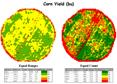 Mapping yield, soil, terrain and other
conditions is becoming commonplace on many farms. The maps help producers visualize the
variation in their fields, but rarely analyzed to their full potential. Emerging data analysis techniques extend
graphic interpretation to data analysis and provide insight into important
relationships within and among the mapped data.
This presentation describes a series of grid-based analysis techniques
designed to highlight unusual areas in a field, identify significant differences
between maps and develop important relationships between one map, such as
yield, and other maps, such as soil conditions and micro-terrain. A case study will serve to illustrate the
considerations and procedures used in site-specific management of agricultural
crops.
Mapping yield, soil, terrain and other
conditions is becoming commonplace on many farms. The maps help producers visualize the
variation in their fields, but rarely analyzed to their full potential. Emerging data analysis techniques extend
graphic interpretation to data analysis and provide insight into important
relationships within and among the mapped data.
This presentation describes a series of grid-based analysis techniques
designed to highlight unusual areas in a field, identify significant differences
between maps and develop important relationships between one map, such as
yield, and other maps, such as soil conditions and micro-terrain. A case study will serve to illustrate the
considerations and procedures used in site-specific management of agricultural
crops.
___________________
Underlying Concerns and Considerations in Remote Sensing of Crop Type and Condition <download Word documents—Part 1 and Part 2>
Joseph K. Berry, Columnist for @gInnovator Newsletter, Meredith Publishing
President,
Phone:
970-215-0825 Email: jberry@innovativegis.com
Website: www.innovativegis.com/basis
David K.
Wright, Graduate Student
Department of Soil and Crop Sciences,
Research and Development,
Red Hen Systems, Inc. Fort Collins, CO 80525
![]()
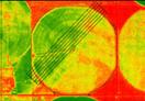 Remote sensing (RS) of crops promises to
revolutionize the monitoring of crop status and conditions. Recent advances in satellite, aircraft and
proximal data collection, coupled with geographic information systems (GIS)
technology and the Internet provide a wealth of new information sources and
ways of visualizing and analyzing these data.
This presentation will investigate the nature of RS data, crop
physiology factors affecting the data, and considerations in data analysis and
interpretation. An ongoing study using a
multispectral video mapping system in monitoring crop nitrogen will serve to
illustrate the important concerns and considerations in remote sensing of
agricultural crops.
Remote sensing (RS) of crops promises to
revolutionize the monitoring of crop status and conditions. Recent advances in satellite, aircraft and
proximal data collection, coupled with geographic information systems (GIS)
technology and the Internet provide a wealth of new information sources and
ways of visualizing and analyzing these data.
This presentation will investigate the nature of RS data, crop
physiology factors affecting the data, and considerations in data analysis and
interpretation. An ongoing study using a
multispectral video mapping system in monitoring crop nitrogen will serve to
illustrate the important concerns and considerations in remote sensing of
agricultural crops.
___________________
These
@gInnovator Online materials are based on an invited presentation for the
Agriculture Discipline Forum, MidAmerica GIS Symposium on “Strengthening
theGrowing Geodata Community,”