Underlying Concerns and Considerations
in Remote Sensing of Crop Type and Condition
by Joseph K. Berry1 and David K. Wright2
Click <here> to
view the complete online slide set and notes accompanying this topic.

www.agriculture.com …Online articles and active discussion forum on
technology
________________________________
Part 2 – In-Field Remote Sensing Applications in Agriculture
 Remote sensing (RS) of crops promises to
revolutionize the monitoring of crop status and conditions. Recent advances in satellite, aircraft and
proximal data collection, coupled with geographic information systems (GIS)
technology and the Internet provide a wealth of new information sources and
ways of visualizing and analyzing these data.
This two-part @gInnovator Online presentation will
investigate the nature of RS data, crop physiology factors affecting the data,
and considerations in data analysis and interpretation. An ongoing study using a multispectral video
mapping system in monitoring crop nitrogen will serve to illustrate the
important concerns and considerations in remote sensing of agricultural crops.
Remote sensing (RS) of crops promises to
revolutionize the monitoring of crop status and conditions. Recent advances in satellite, aircraft and
proximal data collection, coupled with geographic information systems (GIS)
technology and the Internet provide a wealth of new information sources and
ways of visualizing and analyzing these data.
This two-part @gInnovator Online presentation will
investigate the nature of RS data, crop physiology factors affecting the data,
and considerations in data analysis and interpretation. An ongoing study using a multispectral video
mapping system in monitoring crop nitrogen will serve to illustrate the
important concerns and considerations in remote sensing of agricultural crops.
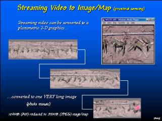 A video clip along a row of corn can be
converted into a photo mosaic consisting of one long strip. In a similar fashion, a flight line across a
field can be constructed and geo-registered.
A video clip along a row of corn can be
converted into a photo mosaic consisting of one long strip. In a similar fashion, a flight line across a
field can be constructed and geo-registered.
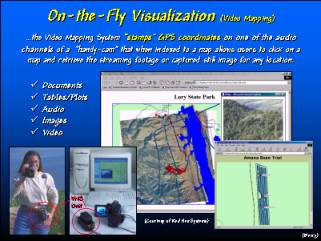
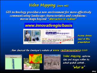
 Video mapping in a field allows a farmer or
crop scout to document conditions. The
streaming video, still images, audio and text are attached to points on a base map
that are retrieved by simply double-clicking on the map point.
Video mapping in a field allows a farmer or
crop scout to document conditions. The
streaming video, still images, audio and text are attached to points on a base map
that are retrieved by simply double-clicking on the map point.
 The video mapping unit is a small,
lightweight box that is connected to the camera for field photographing. In the office the unit serves as an
interface for playback and automatic construction of the computer map linking
the imagery.
The video mapping unit is a small,
lightweight box that is connected to the camera for field photographing. In the office the unit serves as an
interface for playback and automatic construction of the computer map linking
the imagery.
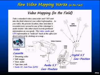 The VMS unit “stamps” the GPS signal onto
one of the audio channels every second while the camera is recording.
The VMS unit “stamps” the GPS signal onto
one of the audio channels every second while the camera is recording.
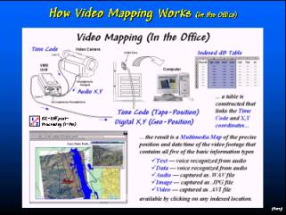 The recorded GPS coordinates (geographic
position) are indexed to the camera’s time code (tape position) such that any
image on the videotape is cross-referenced to its precise location on the map.
The recorded GPS coordinates (geographic
position) are indexed to the camera’s time code (tape position) such that any
image on the videotape is cross-referenced to its precise location on the map.
 Still images and video clips can be
“captured” from the tape and stored with the map for viewing over the Internet.
Still images and video clips can be
“captured” from the tape and stored with the map for viewing over the Internet.
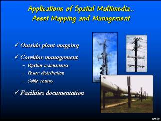 In addition to documenting crop conditions,
video mapping technology can be used to document farm facilities and important
fixed equipment.
In addition to documenting crop conditions,
video mapping technology can be used to document farm facilities and important
fixed equipment.
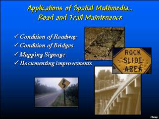 Condition of crops and facilities can
captured at several time periods to assess and document changes.
Condition of crops and facilities can
captured at several time periods to assess and document changes.
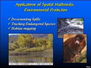 Environmental concerns can be documented and
categorized for proof of compliance.
Environmental concerns can be documented and
categorized for proof of compliance.
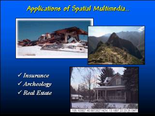 Insurance claims and farm improvements can
be recorded.
Insurance claims and farm improvements can
be recorded.
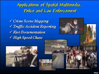 While the Video Mapping System (Red Hen
Systems) was originally developed for crop scouts and harvest records, it is
being applied to a wide variety of other disciplines from police work to
geo-marketing.
While the Video Mapping System (Red Hen
Systems) was originally developed for crop scouts and harvest records, it is
being applied to a wide variety of other disciplines from police work to
geo-marketing.
 For further information on remote sensing
applications in agriculture and video mapping contact Red Hen Systems.
For further information on remote sensing
applications in agriculture and video mapping contact Red Hen Systems.
__________________
These @gInnovator Online materials are based on an invited presentation for the Agriculture Discipline Forum, MidAmerica GIS Symposium on “Strengthening theGrowing Geodata Community,” Osage Beach, Missouri, May 14-18, 2000.
Underlying Concerns and Considerations in Remote Sensing of Crop Type and Condition
1Joseph K. Berry, Columnist for @gInnovator Newsletter, Meredith Publishing
President,
Berry and Associates // Spatial Information Systems
2000
South College Avenue, Suite 300, Fort Collins, CO 80525
![]()
 Phone: 970-215-0825 Email: jberry@innovativegis.com
Website: www.innovativegis.com/basis
2David K. Wright, Graduate Student
Department of Soil and Crop Sciences, Colorado State
University
Research and Development, Red Hen Systems, Inc. Fort
Collins, CO 80525
Abstract
Remote sensing (RS) of crops promises to revolutionize the monitoring of crop status and conditions. Recent advances in satellite, aircraft and proximal data collection, coupled with geographic information systems (GIS) technology and the Internet provide a wealth of new information sources an ways of visualizing and analyzing these data. This presentation will investigate the nature of RS data, crop physiology factors affecting the data, and considerations in data analysis and interpretation. An ongoing study using a multispectral video mapping system in monitoring crop nitrogen will serve to illustrate the important concerns and considerations in remote sensing of agricultural crops.
___________________