|
MapViewerTM
New Revolutions in Map
Making
Price: $249
($79 upgrade)
Version: 4 Media: CD ROM
Operating Systems: Windows 95, 98, Me, NT 4 SP3, 2000, XP and higher

What's
new in MapViewer 4?
View
the MapViewer 4 brochure as a PDF file.

MapViewer is an affordable analytical tool that
allows you to produce publication-quality thematic maps easily. Small
businesses, large corporations, independent consultants, scientists, GIS
analysts, and numerous government agencies are discovering important trends in
their data with MapViewer. Display your data distribution easily and precisely
with more easy-to-use features than ever. Your data is unique and you need the
best mapping software for the job!
A thematic map visually represents the geographic
distribution of your data. MapViewer will help you to:
- understand demographics
- define sales or insurance territories
- outline marketing strategies
- track population trends
- show ecological distribution
- display any geographically distributed data
With MapViewer, you are not limited to the boundaries
and data included in the program. You can import boundary files and data
files in a number of formats to create truly customized maps!
Which MapViewer Features
Would You Like to Learn About?
Map
Types
MapViewer provides you with several map types to
present your data in the most informative way possible. You can combine most map
types in a single window to present several types of data in a single map. The
MapViewer map types include:
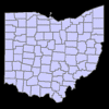
- Base maps contain boundaries without any data
representation. Base maps can be used with other maps to show features such
as roads, streams, city locations, boundaries that have no data associated
with them, and so on.
enlarge
graphic
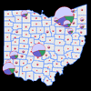
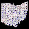
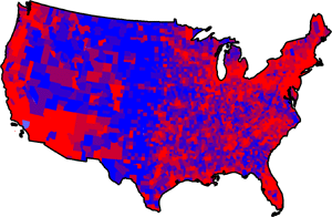
- Hatch maps use colors and fill patterns to
represent data ranges or classes of data for each area on the map.
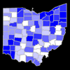
enlarge
graphic
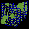
- Density maps also called dot density maps, use
dots to represent data values for areas on a map. On a density map, each dot
represents some data value, so the number of dots drawn in an area is in
relation to the data values associated with that area.
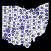
enlarge
graphic
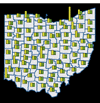
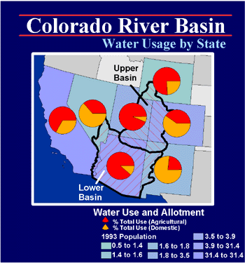
- Pie maps are a way to represent several data
values by drawing a proportionally sized pie chart for each location.
enlarge
graphic
- Bar maps are a way to represent several data
values by drawing a bar chart for each location.
enlarge
graphic
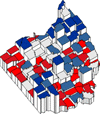
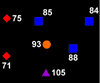
- Symbol maps place a scaled symbol on an area,
curve, or point location on the map. The symbols are scaled in proportion to
the data values represented for each area or point.
enlarge
graphic
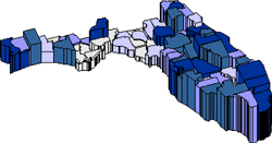
- Prism maps draw each area as a raised prism,
where the height of the prism is relative to the associated data value. NEW:
You can now color the prism maps!
enlarge
graphic
- Line graph maps show line graphs of the data
at each centroid location. By looking at a single line graph, you can see
how the individual data value relates to the whole data set.
enlarge
graphic
- Flow maps scale curves (polylines) on the map.
The curves are scaled in proportion to the data values represented for each
curve.
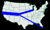
enlarge
graphic
- Pin maps are point location maps that draw a
point at a particular location on a map. NEW: Pin maps can also use colors
and symbols to represent data ranges or classes of data for pin location on
the map.
enlarge
graphic
MapViewer
Boundary and Data Files
The following is a list of boundary and data
files included with MapViewer. These files are suitable for creating a
wide variety of maps. You can also create custom boundaries by combining
existing boundaries or by using the drawing tools. MapViewer can import boundary
files in several different formats so you can also use files created in other
applications.
The MapViewer CD-ROM contains Golden Software�s
entire library of data files and boundary files.
2000 Census
This folder contains two subfolders: 2000 County
Boundaries and 2000 Census Data. The 2000 County Boundaries folder consists of
updated county boundary folders for the year 2000 (Ak2000.gsb-Wy2000.gsb). The
2000 Census Data folder contains US Census data files (Ak2000.dat-Wy2000.dat)
for the year 2000.
City
- Akcity.bna - Wycity.bna: point locations of
cities in latitude/longitude coordinates
- WorldCity.dat: contains latitude/longitude
point locations of miscellaneous world cities in Golden Software Data [.DAT]
format.
DLG
The DLG directory contains USGS 1:2,000,000 scale
DLG files converted to the Golden Software Boundary [.GSB] file format.
US County
- Ak.gsb-Wy.gsb: county boundary files, Primary
IDs are FIPS codes
- Ak.dat-Wy.dat: 1990 US Census data for each
county
- Counties.gsb: map of all US counties
- Counties.dat: 1990 US Census data for all US
counties
US County High Resolution
- Ak_hires.gsb-Wy_hires.gsb: high-resolution
county boundaries
US Miscellany
- ADI.gsb: Arbitron marketing Areas of
Dominant Influence
- Climate_divisions.gsb: US climatic
divisions
- CMSA.gsb: Consolidated Metropolitan
Statistical Areas for the United States
- CMSA&MSA.gsb: Consolidated Metropolitan
Statistical Areas and Metropolitan Statistical Areas for the United States
- Congress_dist.gsb: US Congressional
districts for the 106th Congress
- PMSA&MSA.gsb: Primary Metropolitan
Statistical Areas and Metropolitan Statistical Areas for the United States
- US48.gsb: Contiguous 48 United States
- US50.gsb: United States map in
Unprojected Lat/Long, Alaska and Hawaii in the correct locations
- US50.dat: 1990 Census data for each
state
- US50alb.gsb: United States map in Albers
projection, Alaska and Hawaii by Southwest US
- US50ll.gsb: United States map in
Unprojected Lat/Long, Alaska and Hawaii by Southwest US
- Uscity.gsb: point location of select US
cities
- Usintll.gsb: major US interstates,
highways, and tollways
- PMSA&MSA.gsb: Primary Metropolitan
Statistical Areas and Metropolitan Statistical Areas for the United States
World
- Africa.gsb: African countries
- Antarcal.gsb: Antarctica Albers
projection
- Antarcll.gsb: Antarctica Unprojected
Lat/Long
- Asia.gsb: Asian countries
- Camerica.gsb: Central American countries
- Canada.gsb: Canadian provinces
- China.gsb: Chinese provinces
- Continents.gsb: outline of continents
without interior countries
- Europe.gsb: European countries
- Mexico.gsb: Mexico states
- Namerica.gsb: North American countries
- Oceania.gsb: Australia, New Zealand, and
neighboring island nations
- Pacificn.gsb: Pacific view of the world,
negative coordinates from -360 to 0
- Pacificp.gsb: Pacific view of the world,
positive coordinates from 0 to 360
- Russia.gsb: Russia boundary
- Russia-proj.gsb: Russia boundary split
at 180 degrees
- Samerica.gsb: South American countries
- World.gsb: all countries in the world
- World-proj.gsb: all countries in the
world, Russia and Alaska split at 180 degrees
- World.dat: 1990 data for countries
- Worldcap.gsb: point locations of country
capitals
- Worldcities.dat: lat/long coordinates of
select world cities
World Administrative
This folder contains country boundaries with
administrative interior boundaries. The boundaries define territories within the
country governed as an administrative or political unit, and the resolution
varies from country to country. The territory names are used as the Primary IDs,
and the Secondary IDs are the two-letter, two-number FIPS code for the
administrative unit. These codes are derived from the United States Federal
Information Processing Standards (FIPS) coding scheme.
ZIP3
Akzip3.gsb-Wyzip3.gsb: three-digit ZIP code
sectional centers for the United States
ZIP5
Akzip5.bna-Wyzip5.bna: five-digit ZIP code
boundaries for the United States
Importing
Boundaries from Other Applications
MapViewer can import boundary information in
several different vector and bitmap formats. These include:
- Golden Software GSM, GSB, BLN, PLT, GSI
- Atlas BNA
- USGS DDF (SDTS), DLG, LGO, LGS
- AutoCAD DXF
- Windows Metafile EMF, WMF, CLP
- Bitmap formats include TIF, BMP, TGA, PCX,
GIF, DCX, JPG, PCT, WPG, PNG
- ESRI SHP, E00
- MapInfo MIF
Also, you can read coordinates from worksheet
data files to place point locations on the map. Data files containing any type
of coordinates can be used to indicate points.
Worksheet
MapViewer creates thematic maps by linking
worksheet data to areas or points on the map. If you need to display your own
data on a map, MapViewer includes a full-featured worksheet that allows you to
display, enter, edit, and save your data. You can read data files in many
formats, including XLS, SLK, WKx, CSV, TXT, DAT, MDB, DBF, DB, BNA, and BLN. In
the worksheet you can transform, sort, and calculate statistics on your data.
Additional
Features
There are many additional features that MapViewer
provides, including:
- Add graticules, legends, and scale bars to
your map
- Limit the map to selected coordinates
- Query the map and show the results in several
ways
- Use one of the several map managers to easily
keep track of your map
- Several reports such as centroid report, data
for the selected object, and a general map report are available
- Measure the distance between selected Primary
IDs or click on the map to find distances
- Annotate your maps with text using any
typeface, size, or color
- Display information associated with areas,
curves, and points on your map.
- Display place names, data information, or any
type of text on your maps
- Create circles, squares, rectangles, polylines,
polygons, or symbols at any location on the map
- Create multi-layered maps to present more
information
- Zoom in on areas to show different levels of
detail
- Create custom colors, line styles, and fill
patterns
- Create maps using any coordinate system and
recalibrate maps to use any coordinate system
- Use one of the 25+ map projections
- Convert areas to curves, curves to areas, and
drawing objects to areas
- Edit polylines with break curve, reshape, and
thin boundary
- View the data and the map simultaneously
- Move or copy map features between map layers
- Turn on or off the display of any map or page
features
- Many more!
System
Requirements
- Operating System: Windows 95, 98, Me, NT 4.0
SP 3, 2000, or higher
- 30 MB of free hard disk space
- 800 X 600 minimum monitor resolution
Learn more about Golden Software
Products on this CD!
Home * Surfer
* Grapher * MapViewer
* Didger
Please visit the Golden Software web
site at
http://www.goldensoftware.com!
While visiting the web site, you'll be
able to
buy MapViewer
or download a
demo copy!
|