|
Didger®
.
All the advanced digitizing features you need in a low-cost, unbelievably versatile program
Price: $329
($89 upgrade)
Version: 3 · Media: 1 CD-ROM
Operating Systems: Windows 95, 98, Me, NT 4 SP3, 2000, XP and higher

What's
new
in Didger 3?
View
the Didger 3 brochure as a PDF file
.
Didger is a highly accurate digitizing program that will be an invaluable addition to your software library. In seconds, Didger precisely transforms points, lines, or areas from your paper maps, graphs, aerial photos, scanned raster images, imported vector files, or GeoTIFF images to a versatile digital format you can use with your other software. You name it and Didger can handle it quickly, accurately, and usefully. With Didger’s multitude of features and ease-of-use, this is an unbelievable value, considering the time and effort you will save!! You will soon wonder how you have done your job without this indispensable tool.
What Would You Like to Learn About Didger?
-
One Program - Innumerable Uses
There are innumerable uses for this powerful application. We have compiled this list to give you an idea of the versatility of
Didger, but the ways in which you can use Didger go far beyond this list. If you aren’t sure whether Didger is right for your needs, give us a call and we’ll be happy to discuss the possibilities with you.
- Georeference your raster and vector files for export to other applications.
- Convert your UTM data to Lat/Long or vice versa.
- Create maps from multiple Digital Line Graphs.
- Resample your well log data on specified intervals.
- Digitize oil & gas or monitoring wells.
- Digitize soil, rock-chip, or other sample locations.
- Digitize contours from topo sheets, hand-drawn maps, or computer-generated maps.
- Digitize from aerial or satellite photographs either onscreen or from your tablet.
- Reproduce well logs or strip charts even when you don’t have the original data.
- Digitize township and range lines, section lines, or claim boundaries.
- Digitize owner, operator, or property boundaries.
- Digitize seismic section lines with shot point locations.
- Digitize stream, river, watershed boundaries, lakes, and coastal shorelines.
- Map archeological sample sites.
- Determine stream length, shoreline length, or watershed or lake area.
- Apply Didger in medical research, such as digitizing radiation dose calculations from patient films.
- Study urban growth such as expansion of residential areas.
- Digitize road and street maps and obtain route distances.
- Reproduce hand-drawn cross sections.
- Digitize wildlife information such as animal habitats, migratory routes, and territorial boundaries.
- Digitize geological rock formations, lithologic types, and faults from maps and aerial photos.
- Digitize vegetation boundaries, burn areas, restoration projects, and lumbering areas.
- Determine the area under a curve from a graph.
- Digitize meteorological data to produce isobar maps.
- Create spreadsheet files for data analysis.
- And many other uses!
Some of
Didger’s Superb Features
- Digitize any map, graph, aerial photo, site
map, or printed image regardless of size using any Wintab32 compatible
tablet.
- Digitize a vector or raster project
onscreen.
- Digitize directly into a vector project
using a GPS unit.
- Display all the raw data being sent form
the GPS unit or save it to a data or text file.
- Average the data from the GPS over x number
of sample points.
- See the current position of the satellites
that are being used for a lock for the GPS.
- Display all GPS displays and settings.
- View the current elevation with the GPS
unit.
- Thin and smooth objects by selecting point
selection removal, deviation distance, vertex averaging, or spline smoothing
options.
- Reshape objects by adjusting individual
nodes.
- Combine, split, and/or reverse islands and
lakes.
- Merge two polygons together, or create a
polygon from the intersection of two polygons.
- Import any vector file and retain or apply
up to 23 map projections. Projections supported are: Universal Transverse
Mercator (UTM), State Plane 1927, State Plane 1983, Albers Equal Area Conic,
Azimuthal Equidistant, Eckert IV and VI, Equidistant Conic, Equidistant
Cylindrical, Gauss-Kruger/Gauss-Conformal, Lambert Azimuthal Equal Area,
Lambert Conformal Conic, Mercator, Miller Cylindrical, Molleweide,
Orthographic, Polyconic, Robinson, Robinson-Sterling, Sinusoidal,
Stereographic, Transverse Mercator, and Unprojected Lat./Long.
- Specify one of over 200 datums for your
project.
- Convert the projection of a bitmap in a
raster project.
- Warp, or rubber sheet, your calibrated
raster image to fit any calibration units.
- Import a georeferenced bitmap into a vector
project and overlay it with other data or vector files, or tile it with
other georeferenced bitmaps.
- Add a graticule or a grid automatically to
your project.
- Display the coordinates of selected objects
in the Coordinate Manager.
- Define a polygon and use it to clip a
bitmap
- Specify up to 256 colors to be transparent
for a bitmap.
- Export directly to Surfer using the Create
Surfer Base Map command.
- Use the Create Post Map option when
importing a data file.
- Organize your data into different layers
with the easy-to-use Layer Manager.
- Select objects with And/Or criteria.
- Resample polylines at a specified interval
along either the X or Y axis.
- Use the built-in scanning features to
import a bitmap using any TWAIN compatible scanning device.
- Import vector or raster files using any of
the 27 formats that Didger supports.
- Import data points from 9 different data
formats.
- Export vector or raster files using any of
the 23 formats that Didger supports.
- Import and export spatially referenced
images including GeoTIFF, TFW, and RSF.
- Calibrate your project using Cartesian or
Projected coordinate space types.
- Specify map datum parameters and perform
datum transformations using the following methods: Molodensky, Bursa-Wolfe,
DMA Multiple Regression Equations (RME), and user defined.
- Specify projection parameters when
importing data or vector files.
- Combine vector maps from different
projections into a single map projection.
- Digitize different cultures on separate
layers and export only selected layers.
- Use Didger data with Surfer®, Grapher™,
MapViewer™, or any other mapping, graphing, or database application.
- Associate and display up to four data
values or identifiers for each object.
- Use any units (feet, angstroms, miles,
meters, kilometers, etc.) with any combination of linear or logarithmic
axes.
- Determine allowable error for your project
and work within acceptable standards based on statistical calibration
analyses.
- Obtain length information from polylines.
- Obtain polygon area and perimeter length.
- Zoom in or out to display any portion of
the project.
- Set project limits for the extent of your
project, or let Didger define default limits.
- Automatically assign IDs or assign data as
you digitize.
- Edit polylines and polygons with the
numerous editing tools.
- Define tolerance settings controlling the
chaining and sensitivity of polyline and polygon creation.
- Get immediate help for all aspects of
Didger, including useful digitizing examples, from the extensive online help
system.
- Use the highly accurate and simple-to-use
Tablet Calibration Wizard using between 3 and 256 calibration points.
- Receive unlimited technical support for as
long as you own Didger.
- Create and print a report of all or
selected objects in your Didger project.
- Print the entire map in full color.
- Use the mouse, the digitizing tablet
pointer, or both while completing project work.
- Enjoy over 440 Megabytes of Digital Line
Graphs and Digital Raster Graphs for the Grand Canyon, Rocky Mountain, and
Yellowstone National Parks included on the CD.
- Enjoy over 80 Megabytes of boundary files,
including boundaries for US 3- and 5-digit ZIP codes, US states, US
counties, US State Plane delineations, US city point locations, and world
countries.
- And much more!
Digitizing
Options
There are three ways you can digitize
information from your source documents or files. You can digitize hard copy
documents using any Wintab32 compatible digitizing tablet. You can digitize
digital information, such as vector or raster files, onscreen. You can also use
your GPS unit to digitize your position or trace your route directly onto a map
imported into a vector project!
Raster
Based Maps
With Didger you can perform onscreen
digitizing using an imported bitmap or an image you scanned using Didger’s
scanning functionality. Performing "Heads-Up" digitizing has never
been easier. Didger has all the functionality necessary to import or scan in a
bitmap and calibrate the image in real world coordinates using one of ten
georeferencing methods.
Once the image has been calibrated, Didger
allows you to digitize points, polylines, and polygons with ease. You can export
the digitized objects with the image in GeoTIFF format. Or, simply export the
digitized objects without the underlying bitmap and still retain the
georeferencing information. Use the numerous bitmap filtering options on the
bitmap to make identifying and digitizing the objects a breeze.
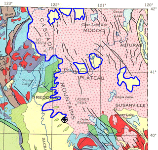
The graphic above shows the
boundary of the Modoc Plateau in Northern California being digitized in blue
from a calibrated raster image of the geology of California.
Georeferenced
Raster Based Maps
A georeferenced raster image retains all
georeferencing parameters. When you import a georeferenced raster image, you can
skip the calibration process and start digitizing immediately. You can import a
georeferenced raster image into a vector or a raster project.
If you import a georeferenced bitmap into a
vector project, you can overlay it with other data or vector files or tile it
with other georeferenced bitmaps.
Import georeferenced
bitmaps into a vector project and then overlay it with data and vector
files.
If you import a georeferenced bitmap into a
raster project, you can convert the projection of the bitmap (if it contains a
projection) or you can warp (rubber sheet) the image to fit your calibration
points.
Import a bitmap into a
raster project, calibrate it, and warp it to fit the calibration points.
Didger also supports importing and/or
exporting ESRI World Files [TFW] and Blue Marble [RSF] files when exporting
georeferenced bitmaps. This is a powerful and advanced feature of Didger!
Vector
Based Maps and Data Files
With Didger you can import a variety of vector
based maps and data files in many formats. Create large coverages easily by
importing several vector or data files into one project. The files will align
according to their coordinate systems. Digitize new features onto an existing
vector plot from your digitizing tablet and map, or digitize onscreen. Change
line styles, object IDs, and add labels to objects with ease. Even import
different files onto separate layers!
If the files are projected and contain
different projection information, they will be converted to the projection of
the first imported file using a datum transformation. You can also convert
vector or data files from one projection to another.
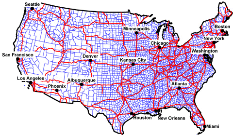
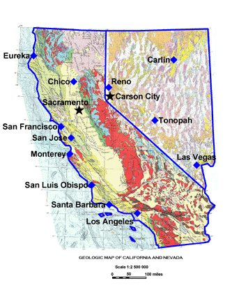
This graphic shows three
vector files and a data file imported into a vector project in the Lambert
Azimuthal Equal Area projection.
Map
Projections and Coordinate Conversions
Converting data from one coordinate system to
another is one of Didger's advanced features. Didger supports over 20
projections and over 200 datums. Easily calibrate or import your files using one
of these projections and convert your coordinates between them. For example,
with a few simple steps Didger can transform your Lat/Long point data into
Universal Transverse Mercator (UTM) coordinates to be used by other mapping
applications. All supported projections include:
| Albers Equal
Area Conic |
Orthographic |
| Azimuthal
Equidistant |
Polyconic |
| Eckert IV |
Robinson |
| Eckert VI |
Robinson-Sterling |
| Equidistant
Conic |
Sinusoidal |
| Equidistant
Cylindrical |
State Plane
1927 |
| Gauss-Kruger/Gauss
Conformal |
State Plane
1983 |
| Lambert
Azimuthal Equal Area |
Stereographic |
| Lambert
Conformal Conic |
Transverse
Mercator |
| Mercator |
Unprojected
Lat/Long |
| Miller
Cylindrical |
UTM |
| Mollweide |
|
In addition to projection and datum
transformations, Didger can also convert coordinates of vector projects by
utilizing either a math or georeference operation. Converting coordinates by
applying a simple math operation allows the user to specify a value to add,
subtract, multiply, or divide to the current vector project. Advanced
georeferencing conversion is also available. By specifying the source and
destination coordinates of the vector project, Didger’s georeferencing methods
allows the user to convert the current project to the new destination coordinate
system. The possibilities are endless and the flexibility is astounding!
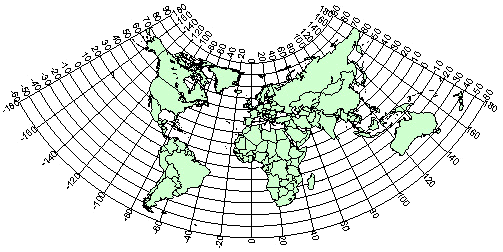
Create stunning world maps in
a variety of projections to convey your information easily. The graphic above
uses the Equidistant Conic projection.
Advanced
Editing Features
- Create line intersections from overlapping polylines.
- Snap undershoot polylines and trim
overshoot polylines.
- Create polygons by using a polygon locator
in the center of linked polyline objects.
- Reshape polylines and polygons.
- Create complex polygons.
- Thin and smooth polylines using one of four
different methods.
- Resample polylines to specified intervals.
- Break or Trim polylines.
- Convert polylines to polygons and vice
versa.
- Connect polylines.
- Create polygons by locator or by ID.
- Merge two polygons together, or create a
polygon from the intersection of two polygons.
- Combine, split, and/or reverse islands and
lakes.
- Select up to 256 colors to be transparent
for a bitmap.
- Sharpen bitmaps, or adjust the brightness,
contrast, and saturation.
- Apply Median or Spatial filters to bitmaps.
- View the coordinates of selected objects in
the Coordinate Manager.
- Edit the coordinates of selected objects in
vector projects in the Coordinate Manager.
Import
and Export Formats
Many sophisticated import and export filters
come with Didger, simplifying the transfer of your data and images to and from
your other applications.
Spatially Referenced formats: GeoTIFF,
TFW, and RSF.
Vector Import formats: EMF,
GSI, GSB, BNA, DLG, LGO, LGS, DXF, PLT, BLN, CLP, WMF, SHP, MIF, DDF, E00.
Raster Import formats: TIF,
BMP, TGA, PCX, GIF, WPG, DCX, EPS, JPG, PNG, PCT.
Data Import formats: XLS,
SLK, DAT, CSV, TXT, BNA, WKx, WRx, BLN.
Export formats: LAS, EMF, GSI, GSB,
DAT, DXF, SHP, BLN, BNA, GIF, BMP, WMF, CGM, MIF, CLP, TIF, TGA, PCX, WPG, PNG,
JPG, PCT, DCX.
Important
News about Digitizing Tablets
Nearly all digitizing tablets work with Didger.
If you already have a tablet, Didger requires a 32-bit WinTab compliant
digitizing tablet driver, available from most tablet manufactures (for no
charge) or from third party vendors.
If you don’t currently own a tablet, you
shouldn’t be discouraged. The price of new, high-resolution digitizing tablets
is astonishingly low. And with Didger’s capabilities, large maps are easily
digitized in a single project so even smaller tablets work quite well.
Visit
our web site to see
a list of tablet manufacturers.
Learn more about Golden
Software Products on this CD!
Home * Surfer
* Grapher * MapViewer
* Didger
Please visit the Golden Software web site
at
http://www.goldensoftware.com!
While visiting the web site, you'll be
able to
buy Didger
or
download a demo copy!
|