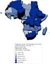
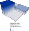
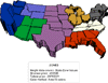
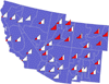
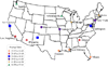
What's New in MapViewer 4?New Map Types Four new exciting map types are available in MapViewer 4, color prism maps, flow maps, line graph maps, and classed pin maps. Color Prism Maps Prism maps can now be colored with one of three methods.
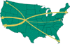
There are also options to white-wash prism walls, control the prism edge color, and change the lighting settings. Flow Maps A flow map scales curves (polylines) on the map. The curves are scaled in proportion to the data values represented for each curve. The wider the curve, the greater the data value associated with the curve. Line Graph Maps Line graph maps show line graphs of the data on each boundary. By looking at a single line graph, you can see how the individual data value relates to the whole data set. Classed Pin Maps Pin maps can now use colors and symbols to represent classes of data for pin location on the map. Categorizing the pins is similar to categorizing data for a hatch map, except the information is point-based rather than area-based. You can control the symbol color and size, the number of bins, and the binning method. Edit Pin Map Labels In MapViewer 4, you can edit, rotate, and move each pin label individually! Full Projection Library You can project your map in one of over 25 different projections. Define your own ellipsoid or use one of the predefined ellipsoids. Also, you can specify one of 200+ datums or create a custom datum. Query MapViewer 4 supports queries for all map types with any data file type. You can use the Analysis | Query command to select, show, or apply properties to the boundaries that meet the criteria. New Organizational Manager MapViewer 4 includes three new organizational managers. The Layer Manager shows all layers and makes them easily accessible. The Object Property Manager allows you to easily view and edit object properties. The Object Data Manager allows you to view and edit the data for an object. Distance There are two ways to measure distance. Use the Analysis | Measure Distance command to find distance by clicking points on a map. Use the Analysis | Distance of Travel command to find distance between the centroids of selected objects. The distance is reported in a file, and you can show the route of travel on the map. Scale Bars Map scale bars can have the first cycle divided into components. You can also choose one of several units for your scale bar (centimeters, chains, feet, inches, kilometers, links, meters, miles, millimeters, nautical miles, rods, US feet, or yards).
New Pattern Editor and Better Pattern Printing In addition to the existing Windows stock patterns and bitmap patterns, we have included a new vector pattern editor in MapViewer 4. You can use one of the existing vector patterns or create your own patterns. The vector patterns can be scaled, so clear pattern printing is possible on any resolution printer or plotter! Import/Export Formats MapViewer 4 can import and export most geographical file types. You can import many file types such as USGS SDTS Topological Vector Files [.DDF], ESRI Shapefiles [.SHP], ESRI ArcInfo Export Format [.E00], and MapInfo Interchange Format [.MIF]. With the availability of digital boundaries on the web and digital boundaries for resale, you can now take advantage of these newly added import types! Other new formats include Golden Software Interchange [.GSI], Enhanced Windows Metafile [.EMF], and Portable Network Graphics [.PNG]. Reports There are several reports available in MapViewer through the View | Reports command. These reports provide information about the data of an object, about the contents of the Object Property Manager, about centroids, and about the entire map. Additional Features
Learn more about Golden Software Products on this
CD! Please visit the Golden Software web site at While visiting the web site, you'll be able to |