Special Session on
Map Analysis and Modeling: Instructor
Materials for Labs, Workshops and Courses
Joseph K. Berry
Keck
Scholar in Geosciences, University of Denver
Principal, Berry & Associates // Spatial Information Systems, Fort Collins,
CO 80524
Email: jberry@innovativegis.com —
Website: http://www.innovativegis.com/basis/
— Phone: 970-215-0825
![]()
Most Geotechnology teaching materials
focus on Geographic Information Systems (
<click
here> to download a printer-friendly version of the Description of the special session
(.pdf document; 1 page)
<click
here> to download the PowerPoint
slide set used in the special session (13MB; 33 slides))
<click
here> to download the Workbook
used in the special session (.pdf document; 26 pages)
Session Description: This
special session describes a comprehensive set of instructional materials
providing hands-on exposure to concepts, capabilities and considerations of
grid-based map analysis and modeling.
Topics covered in the materials include data structure considerations,
display types, vector-raster data exchange, analytical operations and GIS
modeling. The map analysis operations
are divided into logical classes based on similarities in processing and
use— 1) Spatial Analysis operators
of Reclassify, Overlay, Distance, and Neighbors that investigate “contextual
relationships” within and among mapped data layers, and 2) Spatial
Statistics operators of Surface Modeling and Spatial Data mining
that investigate “numerical relationships.”
Numerous examples of GIS models are included and students are encouraged
to edit/modify or formulate their own spatial models.
The session presents a clear outline of instructional
framework as well as “arm” instructors with a comprehensive set of
instructional materials for infusing grid-based map analysis into their
presentations and courses. A short
workbook including the Instructor
Materials two CD set is provided at no cost (www.innovativegis.com/basis/Books/InstructorCDs/).
Background References: See
online papers on A Brief History and Probable Future of Geotechnology, An
Analytical Framework for GIS Modeling and Infusing Grid-Based Map Analysis into Introductory Courses and
online book Beyond Mapping III
posted at www.innovativegis.com/basis/.
|
|
|
|
|
|

Instructor Materials: The
Instructor Materials for
Grid-based Map Analysis and Modeling is a two CD set of teaching materials for
four levels of presentations—1 hour Overview Lecture, 2 hour Seminar, 8 hour
Workshop and 10 week College Course …over 300 slides and hours of hands-on
exercises describing the principles, procedures, considerations and practical
applications of grid-based map analysis.
The College Course materials include laboratory lessons, projects and
even exam questions and answers. Royalty free use for educational purposes; US$ 45 plus shipping; www.innovativegis.com/basis/Books/InstructorCDs/
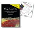
A companion textbook, Map Analysis: Understanding Spatial
Patterns and Relationships, supports the extended Workshop and College
Course offerings. The book contains a
companion CD with color graphics, further readings, exercises and fully
licensed (single seat) software for hands-on experience. US$ 45 plus
shipping; www.innovativegis.com/basis/Books/MapAnalysis/
Author: Dr. Berry has presented
numerous workshops on grid-based map analysis for professionals and is the
author of numerous papers, book chapters and books on map analysis and GIS
modeling. He is the Principal of Berry and Associates // Spatial Information Systems,
consultants and software developers in Geographic Information Systems (
Website: www.innovativegis.com/basis/
Curriculum Vitae:
www.innovativegis.com/basis/basis/cv_berry.htm