|
|
…an introduction to grid-based map analysis and
modeling GEOG 3110,
University of Denver, Geography, Winter Term 2012 Thursdays
6:00-9:30 pm, <Click
here >for a printer-friendly version of this Syllabus <Click here>
for 1-page flyer describing the course |

<Class
website is posted at http://www.innovativegis.com/basis/Courses/GMcourse12/>
<This Syllabus is posted at http://www.innovativegis.com/basis/Courses/GMcourse12/Syllabus/>
Instructor: Joseph
K. Berry, Room 112 Boettcher West, phone
970-215-0825
 About the instructor: http://www.innovativegis.com/basis/basis/cv_berry.htm
Email: jkberry@du.edu; Website: http://www.innovativegis.com/basis
Open Door office hours are Thursdays, 3:00 to
5:00pm (or specially
arranged on Thursday 10:00am-3:00pm or Friday 9:00am-12:00noon) — by email, anytime
Course Materials:
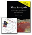
Course
Text is Map Analysis: Understanding Spatial Patterns and Relationships
(Berry, 2007) available at an author’s
discount at the first class meeting ($34.64) or you can order from www.geoplace.com/books/mapanalysis
for $51.95, includes U.S shipping. The
book includes a Companion CD including software Further Readings, Example
Applications, Software and Exercises…
http://www.innovativegis.com/basis/Books/MapAnalysis/Default.htm
Course
Materials including lecture
notes, exercises and readings are posted on the Class Website at…
http://www.innovativegis.com/basis/Courses/GMcourse12/
Course Description:
|
|
|
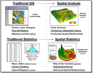
This
intermediate course focuses on the concepts and procedures used in discovering
and applying the spatial relationships within and among maps. It extends the mapping and geo-query
capabilities of
Topics
include the Nature of Mapped Data,
Spatial Analysis and
The
course uses Dr. Berry’s book Map
Analysis: Understanding
Spatial Patterns and Relationships (GeoTec
Media, 2007).
www.innovativegis.com/basis/Books/MapAnalysis/Default.htm
for more information about the book
Application
areas addressed in the course include Natural Resources (Habitat Mapping, Wildfire Risk, Visual
Exposure Impacts, Accessibility), Precision Agriculture
(Soil Nutrient Mapping, Yield
Analysis, Fertility Program Optimization, Erosion Potential), Infrastructure
(Routing and Optimal Paths, Risk
Analysis, Consensus Building), Geo-Business (Store Siting,
Competition Analysis, Retail sales Forecasting, Commercial Properties
Investment) and
numerous other examples draw on the instructor’s consulting, presentations and
research projects.
Course Objectives:
Students
will develop spatial reasoning skills necessary in conceptualizing,
flowcharting and implementing
ü
an understanding
of the differences between data processing in discrete and continuous space
ü
an awareness of
spatial dependency within and among mapped data and its effect on map analysis
ü
a working
knowledge of basic spatial interpolation and statistics procedures
ü
a working
knowledge of grid-based spatial analysis operations to include visual analysis,
effective distance, optimal path density, terrain analysis, contextual
summaries and edge/shape/pattern characterization, and
ü
an ability to
conceptualize, flowchart and implement
Topics and Schedule:
|
Week |
Topic |
|
1 1/5 |
Overview: Reading Assignment links are posted on the Class Website at http://www.innovativegis.com/basis/Courses/GMcourse12/
… Map Analysis book section — Foreword, Preface, Introduction and Table of Contents Online Papers — ”A
Brief History and Probable Future of Geotechnology” and “An Analytical
Framework for GIS Modeling” |
|
2 1/12 |
Maps as Data: Map data types
and their implications; Contouring and thematic mapping effects/implications;
Vector vs. Raster; Raster images, grids and pseudo-grids |
|
3 1/19 |
Reclassifying and Overlaying
Data Layers: Characterizing size, shape, pattern and
arrangement; Point, region and map-wide overlay; Grid math; Spatial
coincidence statistics; Comparing maps; Error propagation |
|
4 1/26 |
Measuring Distance and
Connectivity: Simple vs. effective distance; Proximity
and movement; Accumulation surfaces; Identifying optimal path(s); Viewsheds and visual exposure surfaces; Narrowness
surfaces |
|
5 2/2 |
Summarizing Spatial Context: Calculating
slope, aspect and profile maps; Applying spatial differentiation and
integration; Roving window summary operations; Characterizing edges and
complexity |
|
6 2/9 |
*** online Exam #1 — covers week 1-5
material *** |
|
7 2/16 |
GIS Modeling Examples: Pipeline routing;
Wildfire risk mapping; Micro-terrain analysis; Retail sales prediction |
|
8 2/23 |
Surface Modeling: Basic
statistics and its |
|
9 3/1 |
Spatial Data Mining: Linking numeric
and geographic patterns; Normalizing maps;
Viewing scatter plots; Clustering mapped data; Investigating map correlation;
Developing prediction models; Assessing prediction results |
|
10 3/8 |
Future Directions: Dynamic
map pedigree; Toward a humane |
|
Finals Week |
*** online Exam #2 — covers weeks 6-10
material *** |
Prerequisites:
An
introductory course in
Course Format:
The
class meets once a week for three hours.
Class meetings involve lecture, discussion and real-time demonstrations
of concepts in spatial statistics, spatial analysis and
Guidelines for Preparing Homework
Assignments
Homework assignments use
course software to address a series of questions that demonstrate
The homework assignments will
be completed in two to four member teams.
To help keep track, please name your homework files with the exercise
number followed by the team member names separated by an underscore (e.g., Exercise0_Berry_Smith_Jones.doc). The extension “_graded” will be added when it
is graded and returned to each of the members on the team.
The homework exercises represent over half of your grade (7 Lab
reports plus 1 Project report = 350 + 150= 500 of 900 total points). One of the seven weekly lab reports can be
skipped (student discretion; grade will be determined as the overall average of
other homework exercises). Students can
choose to substitute an individual report (10-15 pages) on any GIS modeling
related topic of their choice for either of the last two lab reports.
Submitting Homework Assignments
Homework assignments are due
by 10:00pm the following Thursday night (7 days to complete). This provides an opportunity to address
questions via email and during the instructor’s office hours. If more time is needed, email a request for
an extension before class specifying a new due date/time.
Submission and Grading: Store your
completed exercises as Word documents (.doc file) and email the group’s
report directly to me (jberry@innovative.com). All exchange of the labs will be in
electronic Web Layout View
format. The document will returned the
following week with grading comments, team evaluation and overall grade.
Method of Evaluation:
Grades
for the course will be determined as follows:
|
Teammate Evaluations (7 labs * 10 + 1 mini-project of 30) |
100 |
|
Homework Exercises (7 assignments worth 50 points each) |
350 |
|
|
150 |
|
Exam 1 (Week 6) |
150 |
|
Exam 2 (Finals week) |
150 |
|
Total Points |
900 |
|
Note: Up to 100 Optional/Extra Credit Points
are available for students wanting to pursue a topic in greater detail or increase
their grade. |
Points
earned are cumulative and translate into a letter grade according to the
following scale:
A+ 97-100, A 93-97%, A- 90-93%, B+ 87-90%, B
83-87%, B- 80-83%, C+ 77-80%,
C 73-77%, C- 70-73%, D+ 67-70%, D 63-67%, D-
60-63%, F 0-60% (tie goes to the
student)
Students are expected to attend class
regularly. Class lectures, discussion
and demonstrations are an important part of the course that is difficult to
reconstruct. Excused absences include
illness, death in the family or participation in a DU sanctioned event. If you must miss class, please notify the
instructor prior to the
class meeting so arrangements for makeup of the material missed can be
made.
Unexcused late homework assignments without
prior notification receive a maximum possible of 45 points (10% penalty) if
turned in before to the next class meeting and will not be accepted (0 points)
if more than one week late. There are no
make-up exams except for excused absences with prior notification. Students may review their current grade at
anytime during office hours; periodic summaries will be emailed.
Course
Software
All of the course
software is installed on the GIS Lab computers.
You can install the software to your own computer from the Map
Analysis book’s companion CD or download from the Internet—
 Microsoft Office [you need to have working
versions of Microsoft Office applications Word,
PowerPoint and Excel loaded on your computer]
Microsoft Office [you need to have working
versions of Microsoft Office applications Word,
PowerPoint and Excel loaded on your computer]
![]() Adobe Reader [download and install from the Internet
— Windows-based program for viewing/printing
documentation files (.pdf); free software; see www.adobe.com/products/acrobat/readstep2.html for more
information on Adobe Reader and free download]
Adobe Reader [download and install from the Internet
— Windows-based program for viewing/printing
documentation files (.pdf); free software; see www.adobe.com/products/acrobat/readstep2.html for more
information on Adobe Reader and free download]
 SnagIt [download and install from the Internet — screen capture software; 30 day evaluation; see www.techsmith.com/ for information on fully licensed system
($37.95 Academic
version)]
SnagIt [download and install from the Internet — screen capture software; 30 day evaluation; see www.techsmith.com/ for information on fully licensed system
($37.95 Academic
version)]
 MapCalc Learner [install from the Map Analysis
book Companion CD — grid-based map
analysis software included with the course
materials provided by the instructor]
MapCalc Learner [install from the Map Analysis
book Companion CD — grid-based map
analysis software included with the course
materials provided by the instructor]
 Surfer Demo [install Version 8 from the Map Analysis book Companion CD — surface modeling and 3D display software included
with the course materials
provided by the instructor; also you can download Version 10 from www.goldensoftware.com/demo.shtml
but the exercises in the course will not directly correspond; see
www.goldensoftware.com and
select “Productsà
Surfer” for more information on fully licensed system ($699)]
Surfer Demo [install Version 8 from the Map Analysis book Companion CD — surface modeling and 3D display software included
with the course materials
provided by the instructor; also you can download Version 10 from www.goldensoftware.com/demo.shtml
but the exercises in the course will not directly correspond; see
www.goldensoftware.com and
select “Productsà
Surfer” for more information on fully licensed system ($699)]
___________________________