|
Epilog – The
Many Faces of GIS |
Map
Analysis book/CD |

Pathways
to GIS — explores different paths of GIS adoption for five
disciplines (Natural Resources, Facilities Management, Public Health, Business
and Precision Agriculture)
A
Multifaceted GIS Community — investigates the technical shifts and
cultural impacts of the rapidly expanding GIS tent of users, application developers
and tool programmers
Further Reading
— six additional sections organized into two parts
<Click here>
for a printer-friendly version of this
topic (.pdf).
(Back to the Table of Contents)
______________________________
Pathways to GIS
(GeoWorld, December 2006)
When did you get involved with GIS technology? How did you get involved? What was your background? What were your application objectives? Answers to these questions define your personal Geotechnology Adoption Path and are unique as you are.
Reflection on generalized adoption pathways for different disciplines can shed light on why a one-sized, all-purpose GIS paradigm is so elusive. Figure 1 is an attempt at describing alternate pathways for several disciplines in which I have experience (and considerable scar tissue) since the mid-1970s.
The ordering of the list is neither arbitrary nor chronological. It reflects the similarities among mapping legacies, early applications and initial ownership groups that characterize various pathways to GIS. It is interesting to note that while Natural Resources and Agriculture share common sociological, cultural, political and biological footings, their geotechnology adoption paths are radically different, and in fact, form polar extremes.
The Natural Resources community was one of the earliest groups to follow the geographers’ rallying cry in the mid-1970s; enticed by the prospect of automating the mapping process. Their extensive paper-map legacy involved tedious aerial photo interpretation and manual cartography to graphically depict resource inventories over very large areas. The early GIS environment was a natural niche for their well-defined mapping processes and products.
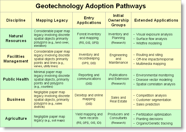
Figure1. Adoption
pathways vary in mapping legacies, early applications and initial ownership
groups to form differing geotechnology paradigms.
Agriculture, on the other hand had little use for traditional maps, as soil maps are far too generalized and broadly report soil properties instead of nutrient concentrations and other field inputs that farmers manage. Their primary uses for traditional maps were in Boy Scouts or hunting/fishing in mountainous terrain far away from the family farm. This perspective changed in the mid-1990s with the advent of yield mapping that tracks where things are going well and not so good for a crop— a field-level glimpse of the geographic distribution of productivity leading to entirely new site-specific crop management practices.
The alternative perspectives of maps as Images of inventory or as Information for decision-making are the dominant determinants of geotechnology adoption paths. GIS entry was early and committed for those with considerable paper-map legacy and well-defined, easily extended applications. While immensely valuable, automation of traditional applications focus on efficiency, flexibility and cost savings and rarely challenge “how things are done,” or move beyond mapping and basic spatial database management.
Disciplines with minimal paper-map legacies, on the other hand, tend to develop entirely new and innovative applications—the adoption tends to be less evolutionary and more revolutionary. For example, precision agriculture is an application that while barely a decade old, is radically changing crop management practices, as well as guidance and control of farm machinery by extending the traditional spatial triad of RS, GIS and GPS to Intelligent Devices and Implements (IDI) for on-the-fly applications.
The character and constituency of the initial ownership group in a discipline also determines the adoption pathway. For example in the U.S. Forest Service and most Natural Resource entities, the nudge toward GIS was primarily controlled by inventory units at regional and higher bureaucracy levels. The early emphasis of this group was on compiling very large and complex spatial databases over a couple of decades before extensive application of these data—sort of “build it and they (applications) will come.”
Contrast this with the Agriculture ownership group comprised of independent crop consultants and individual farmers focusing on a farm landscape of a few hundred acres per field. The database compilation demands are comparatively minor, and more importantly the return on investment stream must be immediate, not decades. Since they didn’t have a mapping legacy, efficiency and cost saving of data collection/management weren’t the drivers; rather crop productivity and stewardship advancements guided the adoption pathway.
Now turn your attention to the relative positions of the three disciplines in the center of the table. Business’ heritage closely follows that of Agriculture— negligible mapping legacy with radically innovative applications involving a relatively diverse, unstructured and independent user community. Mapping in the traditional sense of “precise placement of physical features” is the farthest thing from the mind of a sales/marketing executive. But a cognitive map that segments a city into different consumer groups, or characterizes travel-time advantages of different stores, or forms a sales prediction surface by product type for a city are fodder for decisions that fully consider spatial information and patterns. From the start, geo-business focused on new ways of doing business and return on investment, not traditional mapping extensions.
Contrast this paradigm with that of a Facilities Management engineer responsible for a transportation district, or an electric transmission network, or an oil pipeline—considerable mapping legacy that exploits basic mapping and spatial database capabilities to better inventory installed assets within a large, structured, utility-based industry. Like Natural Resources, the initial on-the-line mapping entry to GIS is broadening to more advanced applications, such as optimal path routing, off-the-line human/environmental impact analysis and integration of video mapping of assets and surrounding conditions.
Now consider Public Health’s pathway— minimal paper-map legacy primarily for graphic display of aggregated statistics within very large governmental agencies. Its adoption of geotechnology has lagged the other disciplines. This is particularly curious as it has a well-developed and well-funded research component similar to those in Natural Resources and Agriculture. While these units have been proactive in GIS adoption, the heritage of Public Health research is deeply rooted in traditional statistics and non-spatial modeling that has hindered acceptance of advanced spatial statistics and map analysis techniques. The combination of minimal paper-map legacy and minimal enthusiasm for new applications within large bureaucracies has delayed geotechnology adoption in Public Health—a revolution in waiting.
I have used the Geotechnology Adoption Pathways table in numerous workshops and college courses. Invariably, it incites considerable discussion as students ponder their own pathway and extrapolate personal experiences to those of other students and related disciplines. At a minimum, the lively discussion encourages students to think outside their disciplinary box and confirms the multifaceted GIS community that we’ll explore in the next section.
(GeoWorld, January 2007)
While
mapping has been around for thousands of years, its digital expression is only
a few decades old. My first encounter
with a digital map was as an undergrad research assistant in the 1960s with Bob
Colwell’s cutting-edge remote sensing program at UC Berkeley. A grad student had hooked up some
potentiometers to the mechanical drafting arm of a stereographic mapping
device.
The
operator would trace a dot at a constant elevation around the 3D terrain model
of hills and valleys created by a stereo pair of aerial photos. Normally, the mechanical movements of the dot
would drag a pen on a piece of paper to draw a contour line. But the research unit translated the movement
into X, Y coordinates that were fed into a keypunch machine—ka’wapa, ka’wapa,
ka’wapa. After a few months of tinkering,
the “digital contour lines” for the school forest were imprisoned in a couple
of boxes of punch cards.
The
next phase of simply connecting the dots proved the hardest. Although UC Berkeley was a leading research
university with over 42,000 students, there was only one plotter
available. And like the Egyptian period
there were only a couple of folks on campus who could write the programming
hieroglyphics needed to control the beast.
Heck, computer science itself was just a fledgling discipline and GIS
was barely a gleam in a few researchers’ eyes.
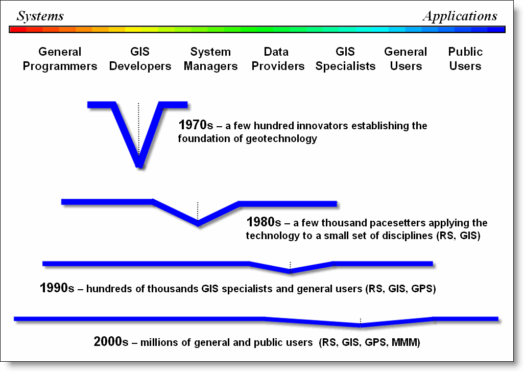
Figure
1. The evolution of the Geotechnology
Community has broadened its membership in numbers, interests, backgrounds and
depth of understanding.
The
old-timer’s story sets the stage for a discussion of the human-ware evolution
in geotechnology (see figure 1). In the
1970s the GIS community consisted of a few hundred research types chipping away
at the foundation. A shared focus of
just getting the technology to work emphasized appropriate data structures,
display capabilities and a few rudimentary operations. In fact, during this early period a
“universal truth” in data structure was sought that fueled a decade of academic
crusades between vector-heads and raster-heads.
My remote sensing background put me in the dwindling raster camp that
eventually circled the wagons around the pixel (picture element) and image
processing that effectively split GIS and RS for a decade.
The
1980s saw steady growth in GIS and the community expanded from few hundred
researchers to a few thousand pacesetters focused on applying the infant
technology. The community mix enlarged
to include more traditional programmers on the systems side and systems
managers, data providers and GIS specialists in a few of the mapping-oriented
organizations on the application side.
Most of this effort focused on vector processing of discrete spatial
objects (point, line and polygon features).
While the greatest effort was on developing databases, great strides in
cartographic modeling were made to mimic manual map analysis, such as
intersection, overlay, buffer and geo-query.
At the same time, advances in hardware and software began to bring GIS
in reach of more and more organizations; however GIS continued to be a
specialized unit “down the hall and to the right.”
Now
compare the community lines for the 1970s and 1980s in the figure. First note the extension to more professional
experiences—some defining entirely new fields, such as GIS specialist. In addition, the 1980s line flattens a bit to
indicate that the average “depth of expert spatial knowledge” within the
community declined from that of the laser-focused research types. Finally note that the “keel of knowledge”
shifted right toward the system managers and application focus.
These
trends in the GIS community mix accelerated in the 1990s. On the system side professional programmers
restructured, extended and enhanced the old unstructured FORTRAN and BASIC code
of the early innovators into comprehensive flagship GIS systems with graphical
interfaces. The GIS developers stopped
coding their own systems and used the toolkits to develop customized solutions
for individual industries and organizations.
System managers, data providers and GIS specialists provided the utility
and day-to-day attention demanded by the operational systems coming on line.
On the
application side, a maturing GPS industry was fully integrated and RS returned
to the geotechnology fold. As a result,
hundreds of thousands of general users of these systems with varying
backgrounds and application interests found GIS on their desktops and joined
the community mix. The shift toward
applications diminished the depth of knowledge and further shifted its keel to
the right. At one point this prompted me
to suggest that GIS was “a mile wide and an inch deep,” as many in the wave of
new comers to GIS did so through an enlarged job description and a couple of
training courses.
If that
is the case, then we are now ten miles wide and a quarter-inch deep. In retrospect and a bit of reflection on the
2000s community line suggests that is exactly where we should be. While there are large numbers of
deeply-keeled GIS experts, there are orders of magnitude more users of geotechnology. The evolution from a research-dominated to a
user-dominated field confirms that geotechnology has come of age. In part, this is a natural condition of all
computer-based disciplines brought on by ubiquitous personal computers and
Internet connections. The dominant focus
of this phase, from webmaster to the end user, is on accessing spatial
information. Couple this with the
current multimedia clamor and 3D visualization, such as Google Earth, a whole
new form of a map is becoming the norm.
So what
is under the flap of the ever enlarging tent of GIS? My guess is that it will become a fabric of
society with most public users not even knowing (or caring) that they are using
geotechnology. At the same time, a
growing number of general users will become more comfortable with the
technology and demand increased capabilities, particularly in spatial analysis,
statistics and modeling.
This
will translate into new demands on developers for schizophrenic systems that
are tiered for various levels of users.
Most users will be satisfied with simply accessing digital forms of
traditional maps, geo-query and driving directions, while other more
knowledgeable users, will access GIS models to run sophisticated map analyses
and scenarios for planning and decision-making.
Also I
suspect that the 2010s will see a whole new community line with two keels like
a catamaran—one on the right (GIS specialist, General Users and Public Users)
emphasizing applications involving millions and another on the left (General
Programmers, GIS Developers and System Managers) emphasizing systems involving
thousands. This dualistic community will
completely change the evolutionary character of the GIS community into a
radically different revolutionary group.
The
biggest challenge we face is educating future GIS professionals and users to
“think with maps” instead of just “mapping.”
The digital nature of modern maps has forever changed what a map is and
how it can be used. Map analysis
capabilities will serve as the catalyst that enables us to fully address
cognitive aspects of geographic space, as well as characterizing discrete
physical features.
_____________________
Further Online
Reading: (Chronological
listing posted at www.innovativegis.com/basis/BeyondMappingSeries/)
(GIS Community Issues)
Is GIS Technology Ahead of Science?
— discusses several issues surrounding the differences in the
treatment of non-spatial and spatial data (February 1999)
Observe the Evolving GIS Mindset — illustrates
the "map-ematical" approach to analyzing mapped data (March
1999)
(GIS Education Considerations)
Where Is GIS Education — describes
the broadening appeal of
Varied Applications Drive GIS
Perspectives — discusses how map analysis is
enlarging the traditional view of mapping (August 1997)
Diverse Student Needs Must Drive GIS
Education — identifies new demands and students that
are molding the future of GIS education (September 1997)
Turning GIS Education on Its Head
— describes the numerous GIS career pathways and the need to
engage prospective students from a variety of fields (May 2003)
(Back
to the Table of Contents)