6th Annual GIScience in Higher Education Summit
March 21, 2014 —
University of Denver, Denver, Colorado
Posted at http://www.innovativegis.com/basis/present/GISinHigherEd2014/
______________________________________
Presentation:
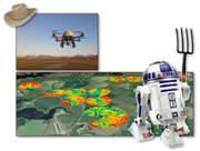
Precision Agriculture: a transformative teaching moment for
Geotechnology, Joseph K. Berry
This presentation investigates the use of Precision Ag’s
unique expression of Geotechnology as an effective vehicle for teaching
fundamental GIS concepts and procedures, particularly in grid-based map
analysis and modeling.
Handout — PowerPoint
(click
to access Handout .pdf and PowerPoint .ppt files)
 Also see…
Precision
Agriculture to Precision Conservation, invited
feature article in Vector1Media (http://vector1media.com/)
an online international magazine promoting spatial design for a sustainable
tomorrow, Part 2 of a two part series, March, 2008. J.K.
Berry, J.A. Delgado and R. Khosla.
Precision
Farming Advances Agricultural Sustainability, invited feature article in Vector1Media (http://vector1media.com/) an online
international magazine promoting spatial design for a sustainable tomorrow,
Part 1 of a two part series, February, 2008. J.K.
Berry, J.A. Delgado and R. Khosla.
_______________________________
Demonstration:
Beyond Mapping Compilation Series,
Joseph K. Berry
 This
demonstration session describes the access, content and searching procedures
for the nearly 1000 pages and more than 750 figures in the Beyond Mapping Compilation Series of Beyond Mapping columns
appearing in GeoWorld (formally GIS World) magazine from March 1989 through
December 2013. The online Series provides a comprehensive
and longitudinal perspective of the underlying concepts, considerations,
issues and evolutionary development of modern geotechnology. (www.innovativegis.com/basis/BeyondMappingSeries)
This
demonstration session describes the access, content and searching procedures
for the nearly 1000 pages and more than 750 figures in the Beyond Mapping Compilation Series of Beyond Mapping columns
appearing in GeoWorld (formally GIS World) magazine from March 1989 through
December 2013. The online Series provides a comprehensive
and longitudinal perspective of the underlying concepts, considerations,
issues and evolutionary development of modern geotechnology. (www.innovativegis.com/basis/BeyondMappingSeries)
Handout (click to access Handout .pdf file ; scale the oversized
poster file to fit page when printing on 8.5x11.0 paper)
_______________________________
Related Paper:
SpatialSTEM: A New Perspective and Conceptual Framework for
Grid-based Map Analysis and Modeling, Joseph K. Berry
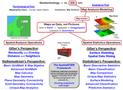 This short paper describes the idea of SpatialSTEM
for understanding and communicating spatial reasoning, map analysis and
modeling fundamentals within a mathematical/statistical framework that
resonates with science, technology, engineering and math/stat communities. The premise is that “modern maps are numbers
first, pictures later” and we do mathematical things to mapped data for
insight and better understanding of spatial patterns and relationships within
decision-making contexts— from Where is What graphical inventories to a Why, So
What and What If problem-solving environment.
This short paper describes the idea of SpatialSTEM
for understanding and communicating spatial reasoning, map analysis and
modeling fundamentals within a mathematical/statistical framework that
resonates with science, technology, engineering and math/stat communities. The premise is that “modern maps are numbers
first, pictures later” and we do mathematical things to mapped data for
insight and better understanding of spatial patterns and relationships within
decision-making contexts— from Where is What graphical inventories to a Why, So
What and What If problem-solving environment.
The map-ematical approach focuses on analytical tools used in
spatial reasoning by non-GIS communities instead of traditional “GIS mechanics”
of data acquisition, storage, retrieval, query and display of map features
directed toward GIS specialists. The goal is to get the STEM communities
to “think with maps” and infuse direct consideration of spatial patterns
and relationships into their endeavors, as an alternative to spatially-aggregated
math/stat procedures that assume uniform or random distribution of map
variables in geographic space.
Paper (click to access Paper .pdf file)