Backcountry Emergency Response: Extending E911 Beyond
the Roads
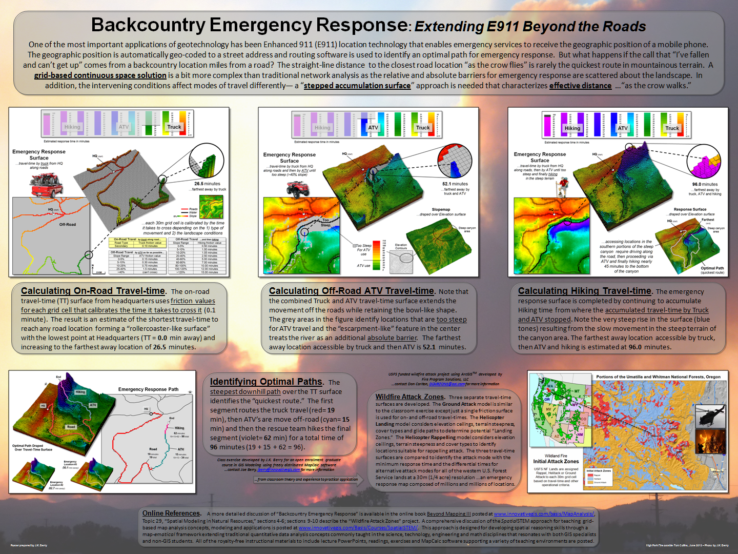 (click to enlarge) One of the most important
applications of geotechnology has been Enhanced 911 (E911) location technology that
enables emergency services to receive the geographic position of a mobile
phone. The geographic position is automatically geo-coded to a street address
and routing software is used to identify an optimal path for emergency
response. But what happens if the call that “I’ve fallen and can’t get up”
comes from a backcountry location miles from a road? The straight-line distance
to the closest road location “as the crow flies” is rarely the quickest route
in mountainous terrain. A grid-based
continuous space solution is a bit more complex than traditional network
analysis as the relative and absolute barriers for emergency response are
scattered about the landscape. In addition, the intervening conditions affect
modes of travel differently— a “stepped
accumulation surface” approach is needed that characterizes effective distance …“as the crow
walks.”
(click to enlarge) One of the most important
applications of geotechnology has been Enhanced 911 (E911) location technology that
enables emergency services to receive the geographic position of a mobile
phone. The geographic position is automatically geo-coded to a street address
and routing software is used to identify an optimal path for emergency
response. But what happens if the call that “I’ve fallen and can’t get up”
comes from a backcountry location miles from a road? The straight-line distance
to the closest road location “as the crow flies” is rarely the quickest route
in mountainous terrain. A grid-based
continuous space solution is a bit more complex than traditional network
analysis as the relative and absolute barriers for emergency response are
scattered about the landscape. In addition, the intervening conditions affect
modes of travel differently— a “stepped
accumulation surface” approach is needed that characterizes effective distance …“as the crow
walks.”
Poster prepared by Joseph K. Berry for GIS Day,
2012. Supporting paper is based on
Beyond Mapping columns in GeoWorld that have been compiled into the online book Beyond Mapping III by Joseph K. Berry posted at www.innovativegis.com/basis/MapAnalysis/. Permission to freely use and distribute
these materials is granted.
For more information, see the online book Beyond
Mapping III, Topic 29 “Spatial Modeling
in Natural Resources” posted at www.innovativegis.com/basis/MapAnalysis/.
__________________________________
Free-use materials posted at www.innovativegis.com/Basis/Papers/Other/BackcountryER_poster/
BackcountryER_Berry.pdf – a 3’ x 4‘ poster (print shop ready; can be printed smaller)
Backcountry_ER.pdf – a 5-page paper describing the approach presented in the poster (includes further online references)
Backcountry_ER_extension.pdf – a 4-page paper describing the use of “Optimal Path Density Analysis” to identify Corridors of Common Access for emergency response
EmergencyResponse.ppt – a PowerPoint slide set describing the three steps (truck, ATV, hiking), model flowchart, and an animated series of slides showing the propagation of the “splash” algorithm wavefront.
________________________
Further
online references: 1) See
www.innovativegis.com/basis/MapAnalysis/Topic29/EmergencyResponse.htm
for an animated slide set illustrating the incremental propagation of the
travel-time wave front considering on- and off-road travel and materials for a
“hands-on” exercise in deriving continuous space emergency response surfaces.
2)
See www.innovativegis.com/basis/MapAnalysis/Topic14/Topic14.htm#Hiking_time
for a more detailed discussion on deriving off-road travel-time surfaces and
establishing optimal paths. 3) For background information in applying
“effective distance” in natural resources, see www.innovativegis.com/basis/MapAnalysis/Topic29/Topic29.htm.
4) See www.innovativegis.com/basis/MapAnalysis/Topic25/Topic25.htm
for detailed discussion of the “splash” algorithm for calculating effective
distance.