|
Topic 6 –
Education Outside the Traditional Lines |
GIS
Modeling book |
Which
Direction Are You Headed? — describes four perspectives on the trailing “S”
in the GIS acronym from a GIS’ers perspective
A
Quick Peek Outside GIS’s Disciplinary Cave — discusses
future directions of geotechnology with particular emphasis on career outlook
and GIS education
GIS
Education’s Need for “Hitchhikers” — establishes the need for
engaging “domain experts” in moving geotechnology to the next level
Fitting
Square Pegs into Round GIS Educational Holes — discusses the need
to engage non-GIS students in developing spatially distributed solutions
Further Reading
— two additional sections
<Click here>
for a printer-friendly version of this
topic (.pdf).
(Back to the Table of Contents)
______________________________
Which
Direction Are You Headed?
(GeoWorld, January 2011)
Earlier I commented on
using the more generalized and palatable term Geotechnology to describe
what some of us over time have referred to as Automated Cartography, Computer
Mapping, Geographic Information Systems, Spatial Database Management, Desktop
Mapping, Geospatial Technology, Geomatics, Map Analysis, Multimedia Mapping and
a wealth of other terms (see Author’s Note).
The discussion identified
the Spatial Triad of Remote Sensing (RS), Geographic Information Systems
(GIS) and Global Positioning Systems (GPS) as core technologies that “utilize
spatial location in visualizing, measuring, storing, retrieving, mapping and
analyzing features or phenomena that occur on, below or above the earth.” While RS and GPS seem to have fairly
succinct and universal meanings, the definition of GIS has sparked continuing
debate. Most will agree on something
like GIS is “a system of hardware and software used for storage, retrieval,
mapping, and analysis of geographic data.”
But what is the interpretation the acronym itself?
My first encounter in the
acrimonious acronym dispute was in the mid-1970s when the “G” in GIS was under
scrutiny. The early GIS folks on the
west side of the Atlantic were convinced it stood for “geographic,”
while those on the eastern side insisted it stood for “geographical.” A quick Google search yields a boat load of
discussion forums still hammering on the grammatical debate. It appears that it boils down to that the “…ic”
in geographic means “of or pertaining to geography," whereas the “…cal”
in geographical means “of geographic"—there seems to be more style than
substance in the debate, as both terms are adjectives.
The “I” in the GIS
acronym seems to be accepted by all as “meaning or pertaining to
information.” The important point to be
made here is that data are simply facts without context. When data are processed, organized and
structured within a given context to make them useful, they become information. This is a significant distinction to keep in
mind as we tackle the different perspectives and interpretations of the
trailing “S” in GIS.
It is the “S” that
carries considerable conceptual, as well as grammatical baggage. Early debate focused on whether it meant
“system (singular)” or “systems (plural).”
The sides at the time seemed to align with whether one had a
comprehensive turnkey commercial system, or cobbled together a bunch of public
domain software packages. With the
advent of today’s specialized apps, mash-ups, cloud computing and the like, it
seems that the “S” might be shifting back toward the plural and away from a
flagship system paradigm.
Figure 1 takes the debate
beyond the grammatical by outlining different substantive interpretations of
the trailing “S” that greatly impacts GIS education, career planning,
on-the-job skills and depth/breadth of understanding of spatial concepts,
procedures and applications. The figure
intentionally uses the intermediary compass positions (officially termed “intercardinal
or ordinal”) of NE, SE, SW and NW
as a nod to astute geographers and as an indication that that the
categorization blends fairly rigid “near cardinal” viewpoints.
At the birth of the
discipline, the “S” unequivocally stood for the hardware, software and dataware
with little or no reference to people or use—simply GISystems. In this early stage (1970s) the focus was on
just cobbling together a system that could handle digital maps without
crashing. The dream might have been
boundless utility but the practical reality was whether maps as numbers was a
viable concept and could be shoehorned into the tinkertoy computing
environments of the day.
Today, the GISystems
perspective still holds that the GIS enabling mechanisms are paramount. Like the pit crew in a NASCAR race, GIS can’t
go anywhere without a finely tuned and fueled computing environment. However, over the years the “systems”
interpretation has expanded to GISpecialist, GIScience, and GISolutions that
primarily respond to differing perspectives on the data versus information
distinction.
The idea that the
trailing “S” defines GISpecialist took hold in the 1990s
as the result of two major forces—uniqueness and utility. As GIS shifted from the “Eureka, it’s alive”
perspective of the early GIS innovators to an operational systems outlook, the
uniqueness of different application environments became apparent. Enterprise systems sprung up and needed
specialists who understood the unique character of an organization’s spatial
data and could serve as in-house experts in its care, feeding and use. By enlarge the GISpecialist’s role was that
of a “down the hall and to the right” resource that field, managerial and
executive folks could tap when they needed maps and spatial information.
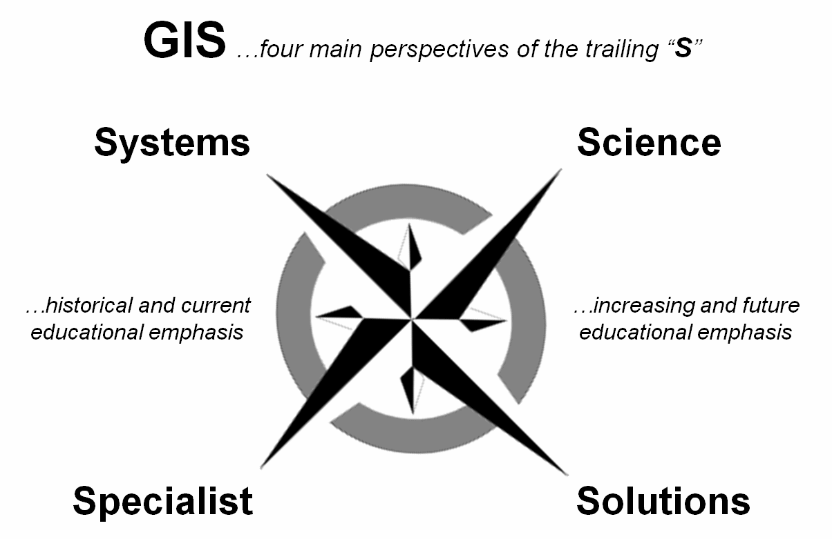
Figure 1. Four perspectives on the trailing “S” in
GIS.
Numerous certificate and
certification programs were designed to produce the needed specialists. At the same time a GIScience
perspective took hold that recognized a more in-depth discipline was coalescing
and would serve full undergraduate and graduate degrees in geotechnology. The GISpecialist has evolved into a
“practitioner” role (what does it take to keep a GIS alive and how can it be
used?) while the GIScience perspective tends more toward the “theoretical” (how
does GIS work, how could it be improved and what else could it do?).
A fledgling GISolutions
perspective has been around for some time, but seems to be capturing a lot more
attention. Early GIS solutions focused
on mapping and geo-query that primarily automated existing business
practices. Cost and time savings in
maintaining and accessing mapped data were at the heart of these highly
successful applications.
However as digital mapped
data became more available, interest turned to how the paper-map-based
practices might be enhanced to improve operations and decision-making. Today, the focus seems to be on entirely new
GIS applications from iPhone crowdsourcing to Google Earth visualizations of
real-time spatial information to advanced map-ematical models predicting
wildfire behavior, customer propensity to buy a product and optimal routing of
a power line.
The “GI” (Geographic
Information) component seems to be a universal root, but the trailing “S” has
evolved through differences in perspective of what GIS is and isn’t. The GISystems and GISpecialist roles form the
foundation of geotechnology’s contemporary expressions whereas the GIScience
and GISolutions roles determine its future directions.
_____________________________
Author’s Note: For a discussion on “Geotechnology” as an
encompassing term, see Beyond Mapping Compilation Series book IV, Introduction, “What’s In a Name?” posted
at www.innovativegis.com.
A Quick Peek Outside GIS’s Disciplinary Cave
(GeoWorld, January 2010)
Over the past few months I
have had the opportunity to participate in several panels discussing the future
directions of geotechnology, with particular emphasis on career outlook and GIS
education (see Author’s Notes). One
particularly intriguing “broad-brush” question setting the stage was “What
are the most radical changes that we have seen in geotechnology’s evolution and
that we will likely see in its future?”
In contemplating the
question I realized that it wasn’t until the late 1990s that I fully realized
the impact of the “perfect geotechnology storm” brought on by the convergence
of four critical enabling technologies; 1) the personal computers’ dramatic
increase in computing power, 2) the maturation of GPS and RS (remote sensing)
technologies, 3) a ubiquitous Internet and 4) the general availability of
digital mapped data.
If any one of these
elements were missing, the current state of geotechnology would be radically
different and most certainly not as robust or generally accepted. Much of our advancement, particularly of
late, has come from external forces. Now
that GIS is “in the limelight” more and more of its evolution will be
influenced by non-specialists’ (vis., the GIS unwashed) and their
perspectives on what maps are and how they might be used.
In the early years, GIS
was “down the hall and to the right,” sequestered in a relatively small room
populated by specialists. Users would
rap on the door and say “Joe sent me for some maps.” Today, geotechnology is on everyone’s desk
and in nearly everyone’s pocket.
Contrary to most GIS perspectives, our contributions have been as much a
reaction to enabling technologies and outside influences as it has been
proactive in the wild ride to mass adoption.
Keep in mind that geotechnology
is in its fourth decade—
-
the 1970s saw Computer Mapping automate the drafting process
through the introduction of the digital map;
-
the 80s saw Spatial Database Management link digital maps to
descriptive records;
-
the 90s saw the maturation of Map Analysis and Modeling
capabilities that moved mapped data to effective information by investigating
spatial relationships; and finally,
-
our current 2000s decade seems to be focusing on Multimedia Mapping
emphasizing data delivery through Internet proliferation of data portals and
advanced display mechanisms involving 3D visualization and virtual reality
environments, such as in Google and Virtual Earths.
The future of our status
as a “mega-technology” alongside the giants of biotechnology and nanotechnology
will be in large part self-determined …that is, if we step out of the
specialist’s closet and fully engage other disciplines and domain experts. The “era of maps as data” (Where is
What?) is rapidly giving way to the “age of spatial information” where
mapped data and analytical tools directly support decision-making (Why, So What
and What If?).
The direct relevance of
geotechnology isn’t just a wall hanging, it’s an active part of the
consideration of geographic space;
whether it’s a personal “what should we do and where should we go?”
decision on a vacation, or a professional one for locating a pipeline,
identifying wildlife management units or establishing a marketing plan for a
new territory.
The key for developing
successful solutions beyond data delivery lies in domain expertise as much, if
not more, than mapping know-how. The
geometrical increase in awareness and use of geotechnology by the masses will
lead to entirely new and innovative applications that we haven’t even dreamed
of (nor can we dream of them in a geotechnology silo). The only way we could drop the ball is to
retreat further into our disciplinary cave.
On a technical front, I
see a radical change in geo-referencing from our 400 year reliance on Cartesian
“squares” in 2-D and “cubes” in 3-D to hexagons (2-D) and dodecahedrals (3-D)
that will lead to entirely new analytic capabilities and modeling applications
(see Author’s Notes). To conceptualize
the difference, imagine a regular square grid morphing into a grid of hexagons
like a tray in a bee hive. The sharp
corners of the squares are knocked-off resulting the same distance from the
centroid to each of the sides defining the cell …a single consistent step
instead of two different types of steps (diagonal and orthogonal) when moving
to an adjacent location. Now consider a
three-dimensional world with 12-sided volume (dodecahedral) replacing a cube …a
single consistent step instead of a series of differing steps to all of the
surrounding locations.
This seemingly slight
shift in spatial theory, however, will revolutionize our concept of geographic
space. At a minimum, it finally will
dispel the false assumption that the earth is flat …at least in our traditional
map world that stacks two-dimensional map layers like pancakes. At a maximum, it will enable us to
conceptualize, analyze and actualize spatial conditions within a fully
three-dimensional representation of the real world. Then all that we will need to do is to figure
out a way to fully account for time, as well as space, in our maps for a
temporally dynamic representation of geography—but that’s another story to be
written by tomorrow’s geo-technologists.
Another important trend
reshaping geotechnology is its move toward commoditization. Commoditization implies the transformation
of goods and services into a commodity thus becoming an undifferentiated product
characterized solely by its price, rather than its quality and features. The product is perceived as the same no
matter who produces it, such as petroleum, notebook paper, or wheat. Non-commodity products, such as televisions,
on the other hand, have many levels of quality.
And, the better a TV is perceived to be, the higher its value and the
more it will cost.
So where is geotechnology
along this commoditization continuum?
Like the other two mega-technologies (bio- and nano-) it
has a split personality with both commodity and non-commodity
characteristics. In our beginning,
research dominated and the mere drafting of a map by a plotter was perceived as
a near miracle in the 1970s. Fast
forward to today and digital maps are as commonplace as they are ubiquitous—a
transformation from “knock-your-socks-off” to commodity status (and maybe “old
dirty socks” that ought to be avoided in a decade or so of 3D GIS technical
advancements).
But we shouldn’t confuse
mass adoption of a map product or service with commoditization of an entire
technology. It is like the product life
cycle in pharmaceuticals from trials, to unique flagship drug, to generic forms
and finally to commodity status. While
the products might cycle to commodity, industries don’t as long as innovation
keeps adding value and new product lines.
What is rapidly becoming
a commodity in our field is generic mapped data and Internet delivery. However, contemporary value-added products
and services are extremely differentiated; such as a propensity map for product
sales, a map of wildfire risk, and a real-time helicopter routing map that
avoids enemy detection. The transition
is a reflection of a paradigm shift from mapped data to spatial
information—less of a focus on automating traditional mapping roles and
procedures, to an emphasis on new ways of integrating spatial relationships
into decision-making ...thinking with maps.
The bottom line is that
commoditization of geotechnology is neither good nor bad, nor an advantage or
disadvantage. It just is a natural
progression of product life cycles and renewed advancements in value-added
features and services through continued innovation. If we fail to innovate, the entire industry
will become commoditized and GIS specialists will hawk their gigabytes of
graphics in the geotechnology commodity market next to the wheat exchange in
Chicago.
The career take-home is
that an individual can’t assume one brush with a four-year smart pill in
education is sufficient. An individual’s
ability to go beyond traditional mapping is the key— from a focus on management,
access, display and geo-query of spatial data (Descriptive Mapping that
is more “data-centric”) to an enlarged focus on integration of enterprise data,
value-added processing and applications of spatial information (Prescriptive
Mapping that is more “application-centric”). The discussion in the next section
investigates some of the pitfalls along the geotechnology career path and
education alleyways.
_____________________________
Author’s Notes: Summaries
of the career/education panels are posted at www.innovativegis.com/basis/basis/cv_berry.htm#KeyNote.
GIS
Education’s Need for “Hitchhikers”
(GeoWorld, February 2010)
The last section
addressed a “broad-brush” panel question on “What are the most radical
changes that we have seen in geotechnology’s evolution, and that we will
likely see in the future?” The discussion
invoked an assessment of the four-decade trajectory of GIS, both in terms of
its driving forces and incremental capabilities and utilities.
Another very basic
question that seems to be making the circuit is “Where do we go from here?
…and how do we make it happen?” As background, one needs to
realize that we have established the basic means of encoding, analyzing,
visualizing and storing geographic information, and have the prerequisite
computer power to digest it all. In addition,
we have maturing standards and a huge quantity of mapped data content in terms
of vector and image data—lock and load, but what is the target?
To many, the future
target is a giant leap beyond mapping and spatial record-keeping to full
integration of geotechnology into real world decision-making processes— from
land management to building design to retail marketing to environmental
protection and a myriad of other applications.
While I am sure there are technical waypoints along the path we take
from here, the human element likely will be the most critical factor of forward
progress, with a revamping of the education component leading the
way.
It’s interesting to note
that our earliest tinkering with GIS had a huge tent with zealots from all
disciplines tossing something into the stone soup of an emerging
technology—foresters, engineers, geographers, epidemiologists, hydrologists,
farmers, geologists to mention but a few.
As the field matured the big tent’s diversity contracted considerably as
“specialists” emerged and formal programs of study and certification
surfaced.
There are many positive
aspects in this maturation, but there also are some drawbacks. In many universities, a GIS Center of
Excellence emerged and lodged in a disciplinary stovepipe of a single college
or department. In addition, the
maturation of the field resulted in a “one shoe fits all” curriculum with focus
on training tomorrow’s GIS’ers.
But this educational
footing is far too limited for a leap from mapping to modeling. The breadth of potential applications
suggests that geotechnology is ill served as the special domain of any
discipline, or even coalescence into a discipline unto itself. A continuum of diverse activists have and are
shaping geotechnology’s future— from those “of the computer,” such as Computer
Programmers, Solutions Developers, and Systems Managers, to
those more “of the application,” such as Data Providers, GIS
Specialists, and General Users (figure 1).
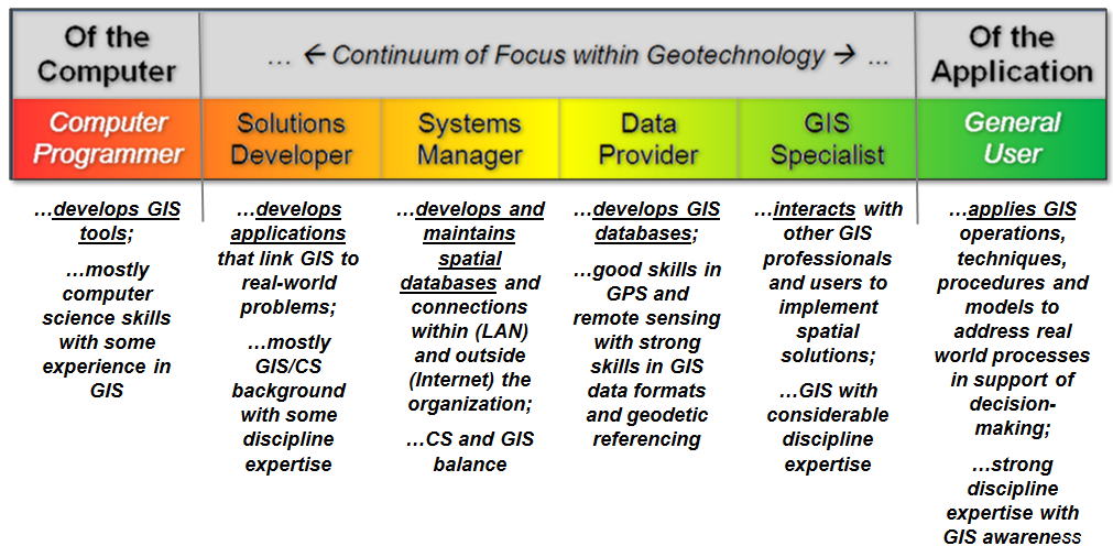
Figure 1. The
continuum of the GIS community reaches from computer science development to a
mosaic of general user applications.
Historically, digital
mapping tilted toward the right side of the continuum as GIS specialists
established and nurtured vast databases that automated existing business
practices. Then map analysis and
modeling shifted focus toward the left side with Solution Developers doing the
heavy lifting by providing new capabilities, models and turnkey solutions.
However, the “bookends”
of this continuum are the current drivers.
Increasingly, computer science and technological advancements in
visualization and access are at the frontier.
With the full embrace of RS, GPS and GIS by Google, Oracle and other
“big-hitters” in the computer industry, geotechnology’s applications are
becoming ubiquitous.
It is hard to pick up a
magazine, watch TV or attend a conference that new and powerful ways of
accessing and interacting with mapped data aren’t being ballyhooed—my
grandmother would be proud. For first
time society comprehends a paperless map and marvels at its uses, from saving
lives with OnStar to finding a store across town to zooming in to a beach in
Belize. While geotechnology is at the
foundation, it has been applied computer industries that hit the ball out of
the park.
It is widely purported
that eighty percent of all data has a spatial component but simply “mapping to
visualize” these data is rarely sufficient in many decision-making arenas. Geotechnology’s next leap forward will be
lead by the other bookend group—involving the active participation of domain
experts in development of entirely new applications addressing complex spatial
relationships. The old adage that “those
with the problems have the solutions” apply applies.
As long as the questions
involved “how do I map that?” or “where is what?” GIS’ers at the
core of the continuum could take the lead.
But as questions progress to “why and so what?” and “do what
where?” the solutions move well beyond mapping—to spatial reasoning, dialog
and problem solving.
Within a modeling
context, disciplinary knowledge of underlying concepts, assumptions, state
variables, driving variables, processes, rates and limits becomes
paramount. In most fields, understanding
of these relationships has been developed through years of non-spatial
science. The idea that spatial
considerations could be “addressed spatially” is foreign—“shouldn’t all that
data be collapsed to a mean and standard deviation?” The notion that there are tools for
characterizing geographic distributions and relationships within and among
mapped data has been outside their experience base, and all too often outside
their comfort zone.
But domain expertise is
the key ingredient for innovative solutions of complex spatial problems. The direct engagement of bright minds with a
practical understanding of the dimensions and complexities of a potential
application has been the “missing link.”
In large part, a “campus chasm” that is too onerous for most students to
cross proves to be the barrier.
Contributing to the
divide is that the preponderance of geotechnology education focuses on “discrete
spatial objects” as a set map features composed of Points, Lines and
Polygons (Vector perspective).
However, most spatial models focus on “continuous spatial
distributions” of geo-registered map variables expressed as gradient
Surfaces (Raster perspective) with all of the rights, privileges and
responsibilities of a true “map-ematics.”
This requires a paradigm
shift from our current thinking of what GIS is and isn’t— from a mapping focus
(warehousing, accessing and visualizing mapped data) to an application focus
(solving spatial problems). This
involves a conceptual shift, not just a structural change. For many GIS’ers the thought is a bit outside
their experience but for non-GIS’ers it is a totally foreign and “off-the-wall”
perspective of a map.
An earlier discussion
about “Turning GIS on Its Head” (see Author’s Note) suggested that the
traditional didactic approach of “fundamentals first, then applications”
severely limits the breadth of exposure of geotechnology across campus. While a “data-centric mindset” that
geotechnology education starts with geographic/cartographic principles and
proceeds through software mechanics works for the inner core players along the
GIS continuum, it effectively excludes the bulk of the bookend players.
An alternative is an
introductory experience where students interact with the mapping and modeling
capabilities at the onset without knowledge of mapping “details,” such as
geodes, datum and projections. Within
this context, the early focus is shifted to a grasp of the problem solving
capabilities of geotechnology— an “application-centric education.” Toward the end of the experience the mapping
details can be introduced within the context of accuracy and precision
assessment, rather than establishing a set of working skills required in the
mechanics of database development and maintenance.
Ideally, this experience
aligns with students disciplinary interests.
As with other aspects of campus life, geotechnology can benefit more
from its diversity than from its oneness.
It’s often perceived condition as a divorced discipline for specialists
on the other side of campus has dramatically hindered geotechnology from
reaching its full potential as a fabric of society, and spatial reasoning as a
matter of fact.
To accomplish this
transition we need to engage applied “domain expertise” in GIS offerings. This means that outreach across campus as
important (and quite possibly more important) than honing courses for training core
professionals. This perspective suggests
less flagship/toolbox software systems and more custom/tailored packages
solving well-defined spatial problems that stimulate “thinking with maps.” The next section will investigate approaches
and procedures that can be used to move beyond the perception that
_____________________________
Author’s Note: See
Beyond Mapping Compilation Series, book III, Epilog, section 6, “Turning GIS Education on Its Head.”
Fitting
Square Pegs into Round GIS Educational Holes
(GeoWorld, March 2010)
The previous section
suggested that geotechnology needs “hitchhikers” to reach beyond mapping. The technology’s first three decades
capitalized on the development of the digital map, first simply for Computer
Mapping, then for Spatial Database Management and then for Map
Analysis by exploiting entirely new encoding, storage, processing and
display tool sets that were radically different from our paper map legacy
(figure 1).
Through the 1990’s, the
new kid on the block, Geographic Information Systems and Science, was in
the driver seat and in control of the emerging technology. However with the new millennium,
geotechnology matured into a mega-technology that captured the full attention
of the computer industry and its reading of the huge potential market for Multimedia
Mapping and Visualization.
The result was near commoditization of many traditional digital mapping
capabilities—tremendous mass acceptance and use occurred, but innovation
shifted from the GIS community core toward the computer science bookend.
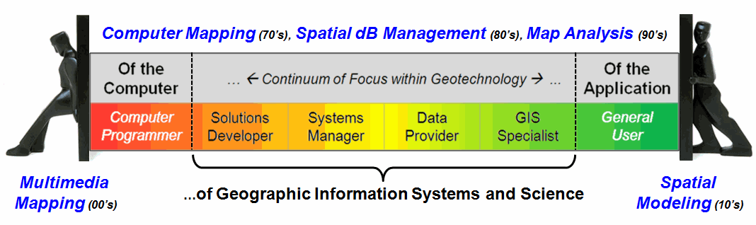
Figure 1. The
bookends of the continuum of the GIS community are the current drivers of
Geotechnology.
Looking forward into the
next decade two dominant thrusts seem to be surfacing. While the bulk of the GIS community will
continue to develop and expand the digital map repository, a small group of
innovators will work with computer scientists to radically revolutionize our
current data and processing structures.
A somewhat larger contingency will engage general and innovative users
in developing Spatial Models that integrate domain expertise, spatial
reasoning and map analysis tools in support of solutions and
decision-making.
Figure 2 depicts the
major components involved in spatial modeling.
Historically, maps focused on precise placement of physical features
(material/tangible) primarily for navigation.
As mapping evolved more non-physical information (logical/cognitive) found
its way into map form. In the past few
decades both types of descriptive characterizations of spatial phenomena have
been incorporated into huge digital mapped data repositories identifying “Where
is What” with sophisticated tools for interacting with the data.
The step from digital map
data to spatially distributed solutions involves a paradigm shift from
descriptive “Where is What” mapping to prescriptive “Why, So What and What If”
modeling. This transition in emphasis involves
the other bookend (users) as much, or more, than it involves the core GIS
community.
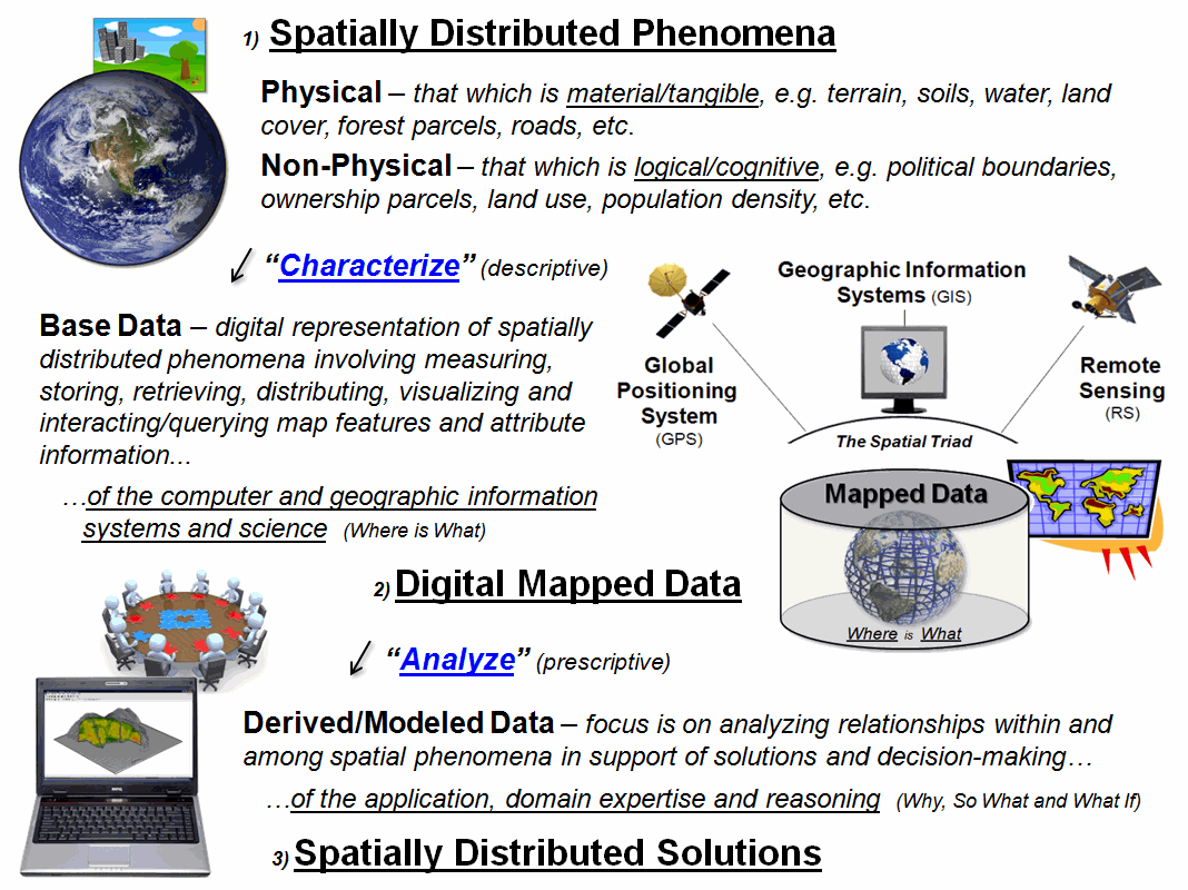
Figure 2. Map analysis and modeling extend mapped
data to spatial solutions.
It suggests that spatial
reasoning needed for the transition lies outside the usual knowledge, skill sets
and experience of GIS’ers. However, most
GIS curricula are designed to service the core community with minimal attention
to reaching other disciplines—they can take our established courses, but
targeted courses for non-GIS’ers focusing on spatial problem identification and
solving are rare indeed.
Yet the development of
curricula and courses for the “unwashed” likely will determine geotechnology’s
future. If we are to reclaim a share of
driver’s seat we need to instill closer and active relationships with the
bookends of the GIS community. The small
group of technology innovators seems well along the way through research
initiatives and industry investments.
The knurly problem lies
in engaging a dispersed set of applied disciplines to develop awareness and
skills in spatial reasoning. The old
adage “they don’t know what they don’t know” applies and over-stuffed
disciplinary curricula keeps most students at bay. What elective “holes” are available are
usually tied-up by concentration tracks that delve even deeper into their
discipline. This, coupled with a
university administrative structure that struggles with inter-disciplinary
efforts, effectively limits exposure of most students to spatial reasoning and
problem solving.
Two potential remedies to
this disciplinary stovepipe “standoff” seem viable—both requiring the
initiative of the geotechnology academic community. First, a concerted “outreach” program needs
to be developed where GIS students are encouraged to develop a secondary
disciplinary thrust that focuses on spatial problem solving instead of the
usual database compilation concentration.
In addition, faculty needs to develop secondary ties across campus that
actively contribute to teaching and research involving spatial reasoning within
applied disciplines.
An important step in this
outreach is recognizing that the GIS tool isn’t the focus and “training”
outside students/faculty in the nuances and fine distinctions of database
construction and GIS software isn’t relevant.
The objective becomes developing an awareness of the capabilities of GIS
through instructive case studies coupled with simple hands-on exercises.
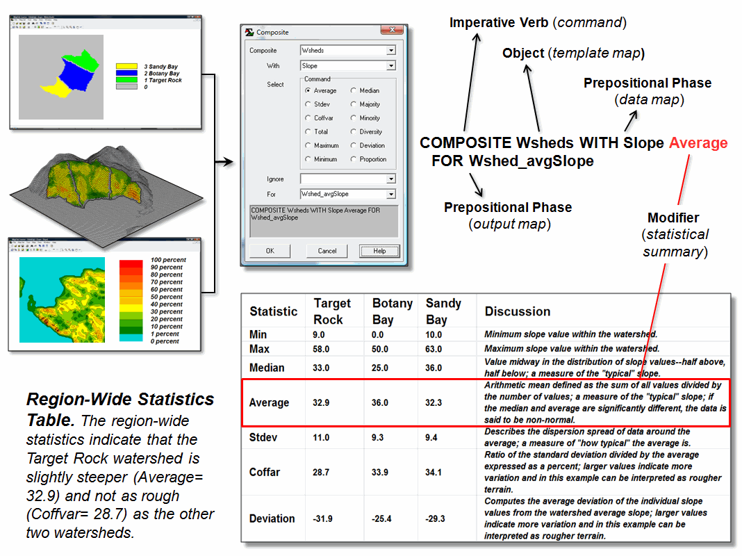
Figure 3. Effective education for non-GIS students
shifts the focuses from mapped data to interacting with model logic and its
spatial reasoning foundation.
Hands-on experience is
critical but it can’t be the same as for traditional GIS students. Flowcharts provide a mechanism for
interacting with a spatial model’s logic and its processing expression (e.g.,
ArcGIS’s Model Builder). The link
between step-by-step logic of a model and the sequencing of the commands
becomes the objective.
For example, figure 3
uses MapCalc Learner (see Author’s Note) to decipher a region-wide overlay
summary that derives the average slope within three watersheds. Note that the command forms a complete
grammatically correct sentence that resonates with less-technical students and
that the contextual help provides information on additional summary options
providing fodder for further discussion.
As GIS education moves
beyond mapping the emphasis lies in full engagement of cross-campus
entities. Like remora and the shark, a
symbiotic relationship with applied disciplines is what will take us
there.
_____________________________
Author’s Note: A listing of several MapCalc Learner
“application exercises” used in special presentations for various applied
disciplines are at www.innovativegis.com/basis/Senarios/Default.html#Application_examples. The educational software system can be
downloaded for free.
_________________________________________
Further Online Reading: (Chronological listing posted at www.innovativegis.com/basis/BeyondMappingSeries/)
Lumpers and Splitters Propel GIS — describes
the two camps of GIS (GeoExploration and GeoScience) (December 2007)
Melding the Minds of the “-ists” and “-ologists”
— elaborates on the two basic mindsets driving the
geotechnology community (July 2009)
Questioning GIS in Higher Education
— describes thoughts and notes from a panel discussion on “GIS in Higher
Education” (June
2012)
(Back
to the Table of Contents)