|
Beyond
Mapping III Topic 2
– Fundamental Map Analysis Approaches (Further Reading) |
Map Analysis book |
GIS Represents Spatial Patterns and
Relationships — discusses the important differences among
discrete mapping, continuous map surfaces and map analysis (April 1999)
<Click here> for a printer-friendly version of this topic (.pdf).
(Back
to the Table of Contents)
______________________________
GIS
Represents Spatial Patterns and Relationships
(GeoWorld, April
1999)
Many of the topics in the
Beyond Mapping Compilation Series of online books discuss the subtle (and
often not so subtle) differences between mapping and map analysis. Traditionally, mapping identifies distinct
map features, or spatial objects, linked to aggregated tables that are visually
interpreted for spatial relationships.
The thematic mapping and geo-query capabilities of this approach enable
users to “see through” the complexity of spatial data and the barrage of
associated tables.
Map analysis, on the other hand, slogs around in the complexity of geographic
space, treating it as a continuum of varying responses and utilizing map-ematical
computations to uncover spatial relationships.
A major distinction between the two approaches lies in the extension of
the traditional map elements of points, lines and areas to map surfaces—an old
concept that has achieved practical reality with the advent of digital maps.
Zones and Surfaces
While much of the information in a
Map surfaces, also termed spatial gradients, often are characterized by
grid-based data structures. In forming a
surface, the traditional representation based on irregular polygons is replaced
by a highly resolved matrix of grid cells superimposed over an area (top
portion of figure 1).
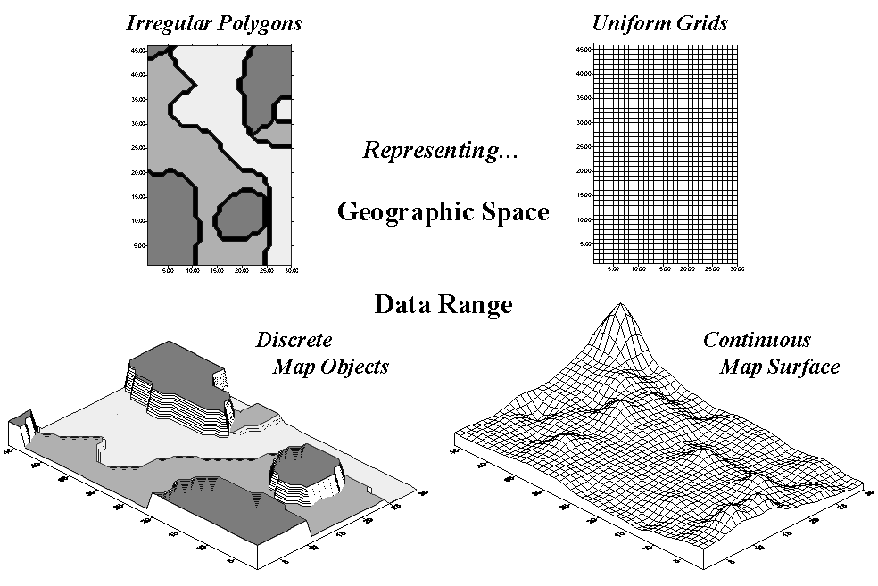
Figure 1. Comparison of zone (polygon) and surface
(grid) representations for a continuous variable.
The
representation of the data range for the two approaches is radically
different. Consider the alternatives for
characterizing phosphorous levels throughout a farmer’s field. One approach, termed zone management, uses
air photos and a farmer’s knowledge to subdivide the field into similar areas
(gray levels depicted on the left side of figure 1). Soil samples are randomly collected in the
areas and the average phosphorous level is assigned to each zone. These, plus other soil data gathered for each
of the zones are used to develop a fertilization program for the field.
An
alternative approach, termed site-specific management, systematically samples
the field, then interpolates these data for a continuous map surface of
phosphorous levels (right side of figure 1).
First, note the similarities between the two representations—the
generalized levels (data range) for the zones correspond fairly well with the
map surface levels (the darkest zone tends to align with the highest levels,
while the lightest zone contains the lowest levels).
Now consider the differences between the two representations. Note that the zone approach assumes a
constant level (horizontal plane) of phosphorous within each zone (Zone#1(dark
gray)= 55, Zone#2= 46 and Zone#3(light gray)= 42, whereas the surface shows a
gradient of change across the field varying from 22 to 140). Two important pieces of information are lost
in the zone approach—the extreme high/low values and the geographic
distribution of the variation. This “missing”
information severely limits the potential for spatial analysis of the zone
data.*
Ok, you’re not a farmer, so what’s to worry?
If you think about it, the bulk of
Surface Modeling
There are two ways to establish map surfaces—continuous sampling and spatial
analysis of a dispersed set samples. By
far the best way is to continuously sample and directly assign an actual
measurement(s) to each grid cell. Remote
sensing data with a measurement for each pixel is good example of this data
type.
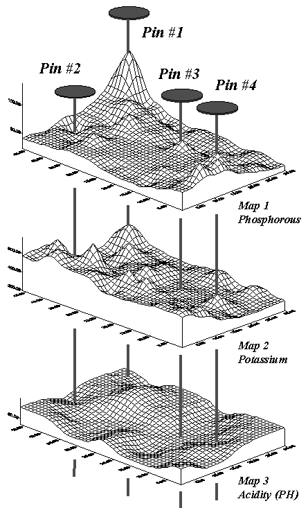
Figure 2. Geo-referenced map surfaces
provide information about the unique combinations of data values occurring
throughout an area.
However,
map surfaces often are derived by statistically estimating a value for each grid
cell based on a set of scattered measurements.
For example, locations of a bank’s home equity loan accounts can be
geo-coded by their street address. Like
“push-pins” stuck into a map on the wall, clusters of accounts form discernible
patterns. An account density surface is
easily generated by successively stopping at each grid cell and counting the
number of accounts within 1/8th of a mile. In a similar fashion, an account value
surface is generated by summing the account values within the radius. These surfaces show the actual “pockets”
(peaks and pits) of the bank’s customers.
By contrast, a zonal approach would simply assign the average
number/value of accounts “falling into” predefined city neighborhoods, whether
they actually matched the spatial patterns in the data or not.
Surface Analysis
The loss in spatial specificity for a map variable by generalizing into zones
can be significant. However, the real
kicker comes when you attempt to analyze the coincidence among maps. Figure 2 shows three geo-referenced surfaces
for the farmer’s field—phosphorous, potassium and acidity (PH). The pins depict four of the 1380 possible
combinations of data for the field. By
contrast, the zonal representation has only three possible combinations since
it has just three distinct zones with averages attached.
The assumption of the zone approach is that the coincidence of the averages is
consistent throughout the entire map area.
If there is a lot of spatial dependency among the variables and the
zones happen to align with actual patterns in the data, this assumption isn’t
bad. However in reality this is rarely
the case.
Table 1.
Comparison of zone and surface data for selected locations.
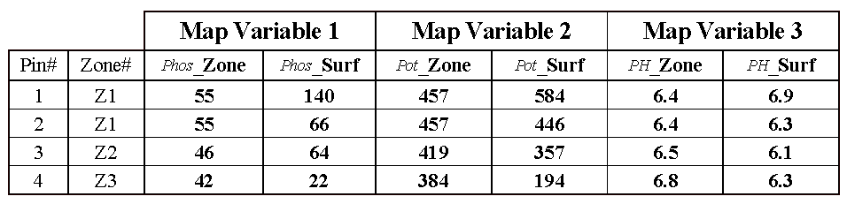
Consider
the “shish kebab” of data values for the four pins shown in Table 1. The first two pins are in Zone #1 so the
assumption is that the levels of phosphorous= 55, potassium= 457 and PH= 6.4
are the same for both locations (as they are for everywhere within Zone
#1). But the surface data for Pin #1
indicates a sizable difference from the averages—150% ([[140-55]/55]*100) for
phosphorous, 28% for potassium and 8% for PH.
The differences are less for Pin #2 with 20%, 2% and –2%,
respectively. Pins #3 and #4 are in
different zones, but similar deviations from the averages are noted, with the
greatest differences in phosphorous levels and the least in PH levels.
While zones might be sufficient for general description and viewing of spatial
data, surfaces are needed in most applications to discover spatial
relationships. As
________________
Author’s
Note: a more detailed discussion of zones and surfaces
is available online at www.innovativegis.com/basis, select
Column Supplements.
(Back to the Table of Contents)