Education, Vocation and GIS Enlightenment
by Joseph K. Berry
Berry &
Associates // Spatial Information Systems, Inc.
2000 South College Avenue, Suite 300, Fort Collins, Colorado, 80525 — joeb@cnr.colostate.edu
Keynote Presentation for IMAGINE Forum, Lansing, Michigan — May 1, 1997
<click here> for a printer-friendly version (.pdf)
In contemplating what to include
in this address reflecting on GIS education, the ideas of Where, What and
Who kept coming to mind. These topics seem suitable for the discourse,
but the story of the three-legged pig makes an ideal place to start.
You see there was this traveling
salesman who noticed a three-legged pig standing in a field. His curiosity was
peaked, so he stopped by the farmhouse and sought out the farmer. "I
noticed the tree-legged pig in your field and am curious as to what
happened—I have never seen one before." "Well let me tell you
about that pig," said the farmer. "My youngest son fell in the pool,
and that darn pig jumped in, pulled him out and was giving him mouth-to-mouth
resuscitation by the time I arrived." "But how’d he lose his
leg?" "Let me tell you something else about that pig. The barn caught
fire and my daughter has trapped inside. The pig shot by us all, grabbed my
unconscious daughter and pulled her from the flames, just as the barn
collapsed." "But how’d he lose his leg?" "What do you
mean? If you had a pig like that could you eat him all at once?"
That’s the state of GIS today… all utilitarian. The early
years of GIS’ing for GIS sake, intellectual enlightenment, and friendly
users have given way to folks who actually intend to something with it and
demand it be user-friendly.
Contrary to my academic background, I will heed the king’s advice
in Alice in Wonderland—"begin at the beginning and go until you come
to the end; then stop"—hopefully before dessert is a distant memory
and your patience is exhausted.
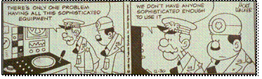
(General Halftrack slide…"there’s
only one problem having all this sophisticated equipment; we don’t have
anyone sophisticated enough to use it")
Where is GIS Education?
GIS means different things to different people. To some, it’s a
tool that extends mapping to the masses. It allows the construction of custom
maps from any desktop. It enables the spatially challenged to electronically
locate themselves on a map, request the optimal path to their next destination,
as well as checking the prices of motels along the way. When coupled with a
cell phone, they can call for help and their rescuers will triangulate on the
signal, and deliver a gallon of gas and an extra large pizza within the hour.
Whether you are a lost explorer near the edge of the earth or soul-searching on
your Harley, finding yourself has never been easier—the revolution of
the digital map is firmly in place.
A new-age real estate agent can search the local multiple listing for
suitable houses, then electronically "post" them to a map of the
city. A few more mouse-clicks allows a prospective buyer to take a video tour
of the homes and, through a GPS-linked handy-cam movie, take a drive around the
neighborhood. A quick geo-query of the spatially-linked database, locates
neighboring shopping centers, churches, schools and parks. The city’s
zoning map, land use plan and proposed developments can be superimposed for a
glimpse of future impacts. Demographic summaries by census tracts can be
generated and financial information for "comparables" can be plotted
and cross-linked for a better understanding market dynamics. Armed with this
information narrowing the housing choices, a prospective buyer can "hit
the ground running" right off the airplane—the revolution of
spatial database management is here.
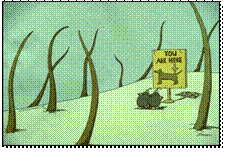
(Location slide…mapping tells us where we are)
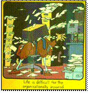
(Impaired slide… spatial database management
organizes massive amounts of information; "Life is difficult for the
organizationally impaired")
Academic Organization (is that an oxymoron?)
However, the "intellectual glue" supporting such Orwellian mapping
and management applications of GIS is still being fought in series of small
skirmishes on campuses throughout the world. In part, the battles reflect the
distribution of costs and benefits of the new discipline. From one perspective,
GIS is viewed as a money pit draining the life-blood from traditional programs.
It appears as an insatiable beast (like the plant’s constant cry of
"MORE!" in the Little Shop of Horrors) devouring whole
computer labs with its gigabyte appetite and top-end taste in peripherals. The
previous assault on "real computing" by the demeaning
distractions of word processing, spreadsheets, and graphics packages, pales by
comparison. The insertion of yet another "techno-science" addition to
the already burgeoning curricula appears to be the last straw. GIS’s
insidious tentacles are tugging at every department.
The classical administrator’s response is to stifle the profusion
of autonomous GIS labs and centralize them into a single "center of
excellence." On the surface, this idea is not without merit. Its
obvious economies of scale and orderly confines, however, often are met head-on
by the savage realities of academic ownership. A GIS oversight committee
composed of faculty from across campus is an organizational oddity in a sea of
established departments and colleges. Strong leadership within the committee is
viewed as a "power-play" by the activist for his or her department
and is quickly countered with the sub-committee kiss of death. Keep in mind the
old adage that "the fighting at universities is so fierce, because the
stakes are so small." Acquisition of space and equipment are viewed less
as a communal good, as they are viewed as one department’s evil triumph
over the others. My nine years as an associate dean hasn’t embittered me,
as much as it has ingrained organizational realities. Bruises and scar tissue
suggest that the efficiencies and cost savings of a centralized approach to GIS
(be it academic or corporate) are largely lost to organizational entropy, user
detachment and a lack of perceived ownership.
As with other aspects of campus life, GIS technology might benefit more from its diversity than from its oneness, with a single academic expression sized to fit all. If GIS is to become a fabric of society and spatial reasoning a matter of fact, it’s tangible expression as a divorced edifice on the other side of campus is dysfunctional. To be embraced and incorporated into existing courses, GIS needs to be as close to its users’ hearts and minds as the door across the hall. An intellectual osmosis easily flows through the semi-permeable walls of a small departmental GIS lab. A well-endowed GIS center makes great publicity photos, but its practical access by faculty and students often rivals the assault on Bastille, guarded by unfamiliar and intimidating GIS-perts.

(Strange beast slide…GIS to many is a strange
beast, but actually it’s an assemblage of many familiar parts)
The GIS Whole Is Greater Than the Sum of Its Parts
Assuming a balance can be met between efficiency and effectiveness of its
logistical trappings, the issue of what GIS is (and isn’t) still remains.
Some of the earlier responses defined it as a mapping science, therefore it
became the domain of the geography/cartography unit on campus. Other responses
emphasized its computer and database underpinnings and placed it in the
computer science department. Most current definitions, however, spring from a
multitude of applications in diverse departments, such as natural resources,
land planning, engineering, business and health sciences. The result is a
patchwork of GIS definitions aligning with the separate discipline perceptions
of its varied applications. This situation is both good and bad. It provides a
context and case studies which resonate among selected sets of students. Unlike
those introductory courses in statistics addressing the probability of
selecting "a white or a black ball from an urn" (get real),
application-specific GIS grabs a student’s attention by directly relating
it to his or her field of interest.
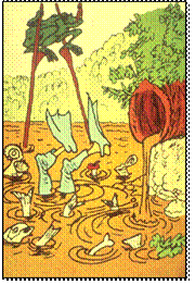
The underlying theory and broader scope of the technology, however, can be lost in practical translation. While geodetic datum and map projections dominate one course (map-centric), sequential query language and operating system procedures might dominate another (data-centric). A third, application-oriented course likely skims both theoretical bases (the sponge cake framework), then quickly moves to its directed applications (the icing). While academicians argue their relative positions in seeking the "universal truth in GIS," the eclectic set of courses on campus becomes its tangible, de facto definition. It’s at this level that a center of excellence in GIS is warranted—operating as a forum for exchange of ideas and expertise, not as a room full of hard and software items. Constructive discourse on what GIS is (and isn’t) can be focused on the paradigms, procedures and people involved, rather than the trappings of the technology and whether "dis’course is better than dat’course" for the typical student.
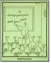
(Beginning Duck slide…actually GIS is as easy
as Beginning Duck)
What is GIS Education?
Our struggles in defining GIS revolve less around its mapping and
management concerns, than its application contexts and expressions. Although
there are variations in data structures, a myriad of geo-referencing
possibilities, and a host of methods to derive thematic mapping intervals,
it’s GIS’s modeling component that causes most of the confusion and
heated debates of what GIS is (and isn’t).
We have been mapping and managing spatial data for a long time. The
earliest systems involved file cabinets of information which were linked to
maps on the wall through shoe leather. An early "database-entry,
geo-search" of these data required a user to sort through the folders,
identify the ones of interest, then locate their corresponding features on the
map on the wall. If a map of the parcels were needed, a clear transparency and
tracing skills were called into play. A "map-entry, geo-search"
reversed the process, requiring the user to identify the parcels of interest on
the map, then walk to the cabinets to locate the corresponding folders and
type-up a report. The mapping and data management capabilities of GIS
technology certainly has expedited this process and has saved considerable shoe
leather… but come to think of it, it hasn’t fundamentally changed
the process. GIS’s mapping and management components are a result of a
technological evolution, whereas its modeling component is a revolution
in our perception of geographic space and spatial relationships.
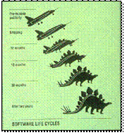
(Software life cycles slide…the software life
cycle begins as an idea for a super-sonic tool, then takes on a somewhat
different shape as implementation reality sets in)
GIS Modeling
This new perspective of spatial data is destined to change our paradigm
of map analysis, as much as it changes our procedures. GIS modeling can
be defined as the representation of relationships within and among mapped
data. A geo-query, such as "all counties with a population over
1,000,000 and a median income greater than $25,000," is not a GIS model.
It simply repackages and plots existing data which describe independent map
entities. Modeling, on the other hand, derives entirely new information based
on spatial relationships, such as coincidence statistics, proximity,
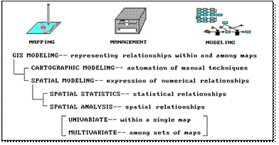
connectivity and the arrangement of map features. As depicted in the
accompanying figure, GIS modeling can take several forms. The two basic
approaches concern cartographic and spatial models. Whereas cartographic modeling involves the automation of manual map
analysis techniques, spatial modeling involves the expression of numerical
relationships of mapped data. The former treats numbers comprising a
digital map as simply surrogates for traditional analog map representations of
inked lines, colors, patterns and symbols. The latter anoints digital maps with
all of the rights, privileges and responsibilities of quantitative data,
thereby forming a new map-ematical
discipline.
(Deeper slide…let’s get a little deeper
into this idea of "numerical relationships among maps")
(GIS modeling slide…leave up during
discussion; for a thorough discussion of Map Analysis and GIS Modeling see An
Analytical Framework for GIS Modeling, a white
paper presenting a conceptual framework for map analysis and GIS Modeling,
BASIS, Fort Collins, Colorado, July, 2009. J.K. Berry and Shitij Mehta.
Posted at www.innovativegis.com/basis/Papers/Online_Papers.htm)
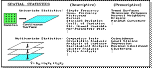
Maps as Organized Sets of Numbers
The numerical treatment of maps, in turn, takes two basic
forms—spatial statistics and spatial analysis. Broadly defined, spatial
statistics involves statistical relationships characterizing geographic
space in both descriptive and predictive terms. A familiar example is
spatial interpolation of point data into map surfaces, such as weather station
readings into maps of temperature and barometric pressure. Less familiar
applications might use data clustering techniques to delineate areas of similar
vegetative cover, soil conditions and terrain configuration characteristics for
ecological modeling. Or, in a similar fashion, clusters of comparable
demographics, housing prices and proximity to roads might be used in retail
siting models.
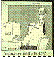
(Response time slide…"Response time seems
a bit slow"; maybe a few slides might help)
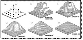
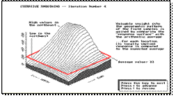
|
Iterative Smoothing can be used to establish a map surface of the spatial distribution in a set of
point-sampled field data.
|
The continuous surface identifies localized
spatial variation inherent in the data; whereas the “Average” of the data assumes a
“typical” value is uniformly distributed throughout the project
area.
|
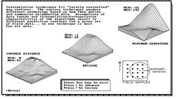
|
Other Spatial
Interpolation
techniques (IDW, Kriging, MinCurvature) can be used to estimate the spatial
distribution of the data; Residual Analysis can be used to determine the best
fitting surface.
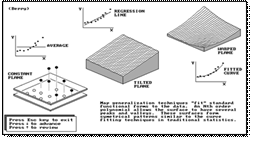
|
Map Generalization techniques fit a mathematical function to the
data to identify the spatial trend inherent in the data.
|
|
A map of the Standard Normal
Variable can be
employed to identify the relative amount of “non-typical”
response at each map location.
|
Many of the non-spatial statistics procedures
extend to Spatial Statistics where continuous surfaces are treated as map
variables; however, do to spatial context and coincidence new
procedures arise.
|
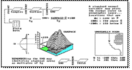
(Describe and explain the similarities and
differences between traditional Non-spatial Statistics and emerging Spatial
Statistics; fundamental concept of a “spatial distribution” expressed
as a continuous map surface as analogous to a “numerical
distribution” represented as a standard normal curve along a number line;
how we can generate a SNV map that identifies “how typical” every
location is in a project are, as opposed to a single “average
value” with its standard deviation estimation of typical
variation—from a scalar generalization of a typical
condition/characteristic to a map of the localized variation throughout a
project area.)
…for a thorough discussion of Map Analysis and
GIS Modeling see An
Analytical Framework for GIS Modeling, a white
paper presenting a conceptual framework for map analysis and GIS Modeling, BASIS,
Fort Collins, Colorado, July, 2009. J.K. Berry and Shitij Mehta. Posted
at www.innovativegis.com/basis/Papers/Online_Papers.htm.
(Empirical verification …a map-ematical approach to maps and mapping
provides a quantitative foothold for map analysis and GIS
modeling—“digital maps are numbers first, pictures later.”)
(Counter intuitive…whew! Now let’s move
on to less counter intuitive stuff)
Spatial analysis,
on the other hand, involves characterizing spatial relationships based on
relative positioning within geographic space. Buffering and topological
overlay are familiar examples. Effective distance, optimal path(s), visual
connectivity and landscape variability analyses are less familiar examples. As
with spatial statistics, spatial analysis can be based on relationships within
a single map (univariate), or among sets of maps (multivariate).
As with all new disciplines, the various types of GIS modeling are not
dichotomous, but identify the range of possibilities along a continuum of
approaches. In addition, most applications utilize a combination of mapping,
management and various types of modeling approaches in their solution.
In all cases, GIS applications involve spatial reasoning of complex
systems, be they geo-business, ecological, or other processes. The GIS toolbox
remains the same, however the applications dramatically change. These
similarities and differences drive our varied perspectives of GIS technology
and provide a framework for discussion of the human issues surrounding GIS
education needs.
(Closed for inventory slide…"closed for inventory")
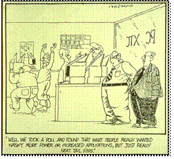
(Tail fin slide…we have focused most of our
energy on database construction, but is a good database with easy access via
the Internet enough?)
Whose GIS Education?
GIS technology is "as different as it is similar" to
traditional mapping and data analysis. Likewise, GIS education needs to
incorporate unconventional concepts and approaches, as well as extending
conventional ones—"business as usual" is out of the question.
The diverse set perspectives of GIS technology provide a useful framework for
discussion of GIS education, as it relates to paradigms, procedures
and people.
Shifting Spatial
Paradigms
Fundamental to understanding GIS is the recognition that a computer map
is a set numbers first, a picture later. How the data is encoded and stored is
important, as well as an appreciation of geographic principles, such as
coordinate systems and map projections, particularly for students emphasizing
database development and production mapping. A basic understanding of computer
environments and operating as well as database management skills, such as
indexing, selection ladders, and macro language proficiency, are important,
particularly for students emphasizing management and modeling of spatial data.
These, and similar topics, represent extensions of exiting concepts of space
and data analysis, adjusted for the digital mapping environment.
Several concepts, however, represent radical shifts in the spatial paradigm.
Take the concept of map scale. It’s a cornerstone to traditional mapping,
but it doesn’t even exist in a GIS. Map scale reports the "ratio of
map distance to ground distance," assuming a specific map output product.
In a GIS you can zoom in and out on a particular area, changing its
"scale" at will—map scale isn’t part of the GIS, but an
artifact of the screen or paper display. However, the related concept of map
resolution is fundamental to GIS as it identifies the level of detail (spatial,
thematic, temporal and mapping) captured in a digital map. Just as it is a
violation to superimpose paper maps of differing map scales, it is a violation
to superimpose digital maps of varying resolutions—both cases result in
pure, dense (but colorful) gibberish.
Similarly, combining maps with different data types, such as multiplying
the ordinal numbers on one map times the interval numbers on
another, is map-ematical suicide. Or
evaluating a linear regression model using mapped variables expressed as
logarithmic values, such as a PH for soil acidity. Or consider overlaying five
fairly accurate maps (good data in) whose uncertainty and error propagation
results in large areas of erroneous combinations (garbage out). It is
imperative that GIS education fully embraces the quantitative aspects of maps
and instills an understanding of its implications beyond the inked line and
paper map paradigm.
New Procedures Relax Old Assumptions
The practicalities of implementing procedures often overshadow their realities.
For instance, it’s easy to use a ruler to measure distances, but its
measurements are practically useless. The assumption that everything moves in a
straight line does not square with real-world—"as the crow
flies," in reality, rarely follows a straightedge. Within a GIS, distance
(shortest straight line between two points) can be extended to proximity (by
relaxing "between two points" to "among sets of points"),
then to movement respecting relative and absolute barriers to travel (by
relaxing "straight line" to "not-necessarily-straight
route").
In practice, a 100 foot buffer around all streams is simple to establish
(as well as conceptualize), but has minimal bearing on actual sediment and
pollutant transport. It’s common sense that locations along a stream that
are steep, bare and highly erodeable should have a larger setback. A
variable-width buffer respecting intervening conditions is more realistic.
Similarly, landscape fragmentation has been ignored in resource management.
It’s not that fragmentation is unimportant, but too difficult to assess
until new GIS procedures emerged. (As an aside, I am up to my arm pits in
landscape structure and precision farming applications and software and have
brought some materials and would be delighted to discuss them at length later.)
These and other bazaar procedures, such as travel-time surfaces, Nth optimal
path density, and data-surface modeling, are challenging old, limiting
assumptions about spatial data and their relationships.
New People and Retreads
These new procedures and the paradigm shift are challenging GIS users and
their educational needs. Potential users first can be grouped by their
interaction with the technology, then by their situation. Three broad types of
users can be identified: Application-centric (routine user, casual user
and interactive user), Data-centric (data entry specialist, database
manager, and system manager), and Procedure-centric (software programmer
and application developer). In turn, these user groups can be further refined
by their disciplinary focus (natural resource, business, engineering,
etc.). The diversity of users, however, often is ignored in a quest for a
"standard, core curriculum." In so doing, a casual user interested in
geo-business applications is overwhelmed with data-centric minutia; while the
database manager receives too little. Although a standard curriculum insures
common exposure, it’s like forcing a caramel-chewy enthusiast to eat a
whole box of assorted chocolates. The didactic, two-step educational approach
(intro then next) is out-of-step with today’s over-crowded schedules and
the diversity GIS users. A case study approach with extensive hands-on
experience provides better focus, but it puts a greater burden on individual
instructors and facilities.
A potential user’s situation has a bearing on GIS education. In the
broadest sense there are two situations: traditional and non-traditional. The
former group includes conventional students flowing through the K-12,
undergraduate and graduate programs. In the long run, GIS exposure will appear
throughout this pipeline. However, in the short run most students are
frantically attempting to retrofit themselves. Traditional courses tuned to a
methodical progression rarely fit their backgrounds and schedules (interests
aside).
Although non-traditional students tend to be older and even less patient,
they have a lot in common with the current wave of "out-of-step"
traditional students. They have even less time and interest in semester-long
"intro/next" course sequences. By default, vocational training
sessions are substituted for their GIS education—"how to"
replaces "what and why." The two estranged student groups, however,
pose an interesting opportunity for partnering between industry and academia. The
need for targeted short courses by both student groups suggests intensive
offerings over weekends and vacation periods. The extended network of in-place
instructional facilities provides the logistical setting, while collaboration
between vendor and academic instructors provides the intellectual material. A
mixed audience of traditional and non-traditional students provides an engaging
mixture of experiences. So what’s wrong with this picture? What’s
missing? Not money as you might guess, but an end run around institutional
inertia and rigid barriers. Adoption of GIS technology can’t wait a
generation for the normal flow through the educational pipeline. A
"steady-she-goes" approach of the institutionalized education tanker
needs turning… or have we missed the boat entirely?
|
|
||
|
Our new operating system “Syntax” exchanger with
“Mind Blowing” software is one of the most revolutionary computer
systems for report production available.
Our syntax software guarantees a semblance of meaningful output. |
This little baby transmits at 800 baud to the printing terminal, which
cranks out 15 pages per minute.
I’ll give you a demo.
Let’s see …environmental impact of a clear cut on a
Furbish Lousewort.
…beep, beep, clank, whir, whiz… |
My,
this is impressive heavy stuff! Actually, it’s gibberish. WHAT? |
|
It’s gibberish. Pure
dense gibberish. HOW
AWFUL! You mean how wonderful!
It’s the best most real looking gibberish money can buy. But
why? |
Who really reads this stuff?
Most just look at the stack of printouts, a few will flip through
it—only one or two will try.
Everyone will read the conclusions—your conclusions Mr.
Resource Manager! |
In
other words, this machine will back up my decisions with impressive but
indecipherable gibberish? Right! Just punch in the
number of pounds of printout you want. WOW!!! |
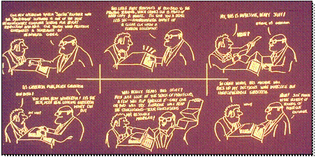
(Gibberish slide…how about this as summary of
the need for GIS education…are we simply instilling new procedures for
handling mapped data or are we providing
powerful new tools for understanding spatial
patterns and relationships that change our paradigm of what maps are and how
they can be used?)
Thank you… any comments, thoughts or questions?