GeoWorld Articles
|
Further Reading for Understanding Spatial Patterns and Relationships (Berry, 2007 GeoTec Media) |
Feature article for GeoWorld, May
2001, Vol. 14, No. 5, pgs. 40-43
<Click here>
right-click for a printer-friendly version of this paper (.pdf).
What's a Map? Media Mapping Technology Is Redefining the Term
by Betsy Pfister, Ken Burgess
and Joe Berry
Introduction
From the
beginning of photography, people have had an interest in where pictures were
taken. In the late 1800s, photographs from all over the world were sought by
eager homebodies who wanted to know what other places were like. These
photographs provided a visual reality to people who previously only had
abstract ideas of other places obtained from representations in maps, art and
literature. Most of the photographs in these early collections had descriptions
of where they were taken written on the back--many were annotated with the
actual latitude and longitude to five significant figures.
Today's GIS users have different ways of understanding
"place." They tend to see places as abstract elements of a
demographic, and they generate endless numbers describing locations and their
relation to other locations. GIS people tend to think of photographs as maps,
using geo-registered aerial or satellite images the same way they use street
data. In doing this, they can lose sight of the fact that abstract
representations on maps are placeholders for reality.
Current and developing technologies for media mapping are changing that
mode of thinking for many GIS users. Media mapping merges photography and
geography to help users understand space by experiencing abstraction and
reality through the integration of maps and images (see Figure 1).
Media Mapping's Roots
The idea behind media mapping isn't new. GIS users have tried a variety
of ways to associate a picture with the location it represents. Solutions for
this vary from low-tech to highly complex. The low-tech version typically
involves taking a picture in the field and then writing down a Global
Positioning System (GPS) location and the photograph's frame number. With luck,
photographers make relatively few mistakes in taking notes. Then someone scans
the photo and manually enters the GPS data and image file into the GIS
database. Hopefully, that person also makes relatively few mistakes. Other than
the "human-error factor," the main deterrent to this method is
inefficiency--it's a pain.
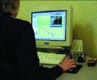
Figure 1. A media map allows
users to click on a location and view pictures or other linked files.
More recently, engineers have come up with some high-tech ways to
automate the process. For example, there are a few different video mapping
technologies available today. Video mapping, the forerunner of media mapping,
refers to geo-referencing video footage. It requires a means of associating GPS
data with video. A mapping software package that can read the encoded GPS data
builds a database that includes the GPS locations referenced to video time
codes. The software displays a map that shows where the video was taken, and
users access desired video footage by clicking locations on a map.
Video mapping often is contracted as a service, because most systems
are based on several pieces of sophisticated equipment requiring skilled
operators. But such services generally produce excellent results. An
interesting example of a video mapping service is Continental Shelf Associates
Inc. (http://www.conshelf.com/),
which provides under-water video mapping services. Coastal and Ocean Resources
Inc. (http://www.coastalandoceans.com/)
provide aerial video mapping and other consulting services. Skyview
Technologies LLC (http://www.skyview-usa.com/ ),
creates video maps from a small blimp. For more demanding users, systems based
on stereo videography produce images that allow GIS users to select any point
in an image and view its geographic coordinates. Ohio State University's Center
for Mapping (http://www.cfm.ohio-state.edu/) developed a GPSVan System with
stereo video capability. They also have developed an Airborne Integrated
Mapping System. Unfortunately, the associated expense and complexity of such
systems tends to alienate most GIS users.
In 1997, Red Hen Systems developed a video mapping system as an
agricultural field-scouting tool (see Figure 2). Perhaps it shouldn't have been
a huge surprise to discover that the agricultural community at the time was a
little "green" on GIS technology. Agriculture consultants and farmers
were leery of trying something new, and they also were a bit skittish about
computers and video hardware.
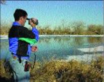
Figure 2. A user demonstrates Red
Hen Systems' VMS 200 product, a forerunner to media mapping that creates
real-time geo-referenced video.
However, experienced GIS users from other fields eagerly adopted the
technology, and the humble agriculture mapping solution became a GIS tool in a
wide array of industry applications. The fledgling technology ended up in the
hands of ecologists, foresters, weed-control managers, archaeologists, the oil
industry, law enforcement officers (see Figure 3), military intelligence
personnel and others. The users all had one thing in common: They wanted to see the locations they marked on their
GIS maps.
Current Evolution
During the last few years, video mapping technology has focused on
streamlining solutions to the photography/geography problem. New software and
hardware components add laser range-finding and digital compass data to the
system. Eventually video mapping, with its emphasis on mapping line objects,
evolved into media mapping, which
features additional support for mapping point objects. Red Hen Systems, for
example, has a MediaMapper product that integrates digital pictures with GPS
locations.
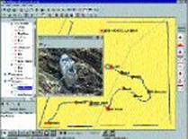
Figure 3. The Wyoming Crime
Laboratory created a training scenario to demonstrate its use of media mapping.
A "victim" died of exposure, and the system helped inventory the body
and various items of clothing.
Video mapping systems still exist, and they're important to those who
require a link between maps and real-time video. For example, aerial
applications are well served by video mapping, and there's a growing interest
in the remote sensing community for this kind of mapping (see Figure 4).
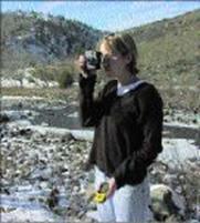
Figure 4. A special application
of media mapping has been developed for aerial remote sensing. The system has
been tested successfully in forestry and agriculture.
However, many GIS users seek something simpler. They don't need video—
they want less hardware, fewer cables, and easier field and desktop operation.
"Exportability" of media maps across GIS platforms is critical. These
issues led to the development of media mapping, which doesn't rely on GPS data
or video as the sole media source.
Media mapping has arrived at a place in time and development in which
fieldwork is as simple as taking photographs. In its current evolution, media
mapping refers to an automated method of adding multimedia files to a GIS
database and then accessing those files by selecting locations on a map.
Today's "media mapper" might be called a "photo-geographer"
or "geo-photographer" who uses a digital still camera in the field
and brings a hand-held GPS receiver along for the ride (see Figure 5).
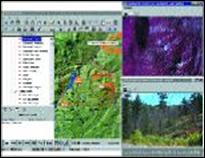
Figure 5. Today's media mapping
products help users merge digital camera images with GPS locations.
Only slightly more complex than taking pictures, a media mapping system
requires GPS receivers to save a track log as users take pictures. This file
then is downloaded to a computer along with the digital images as software
generates maps "hot linked" to pictures. The result allows users to
click a map location and view what's there.
A media map can be associated with any kind of digital media, hence the
evolution of the name from the early video map. Map features can incorporate
multiple links to any kind of file, enabling users to inspect a location
through pictures, notes, audio, streaming video or whatever kind of information
they choose to store.
What's currently available is a map- centric application of the
media-mapping paradigm— the map provides access to the linked information. But
the way GIS users think is evolving, and media mapping brings up interesting
questions about how users will process, access and understand GIS information
in the future. It's somewhat difficult to contemplate or explain the
implications of media mapping, because the GIS community seems largely
indoctrinated with the understanding that "imagery equals map." In
the media-mapping paradigm, imagery equals reality, or site detail, while map
equals abstraction, or distribution of objects in space. As a whole, these
ideas blend hard data with intuitive understanding to expand the limits of what
we can know about a location.
Access to Information
The explosive growth of the digital camera market is bringing about
further changes in our thinking about the future of "spatial media."
It's estimated that 5.5 million digital cameras will be sold this year in the
United States alone. As it stands today, media mapping is successfully making
photographers of geographers. This is logical, because the technology's
development sprang from a map-centric point of view typical of people who are
accustomed to using GPS/GIS technology. However, a closer inspection of
software being developed to support digital camera users leads to the idea of
media mapping from a photo-centric point of view. If users can access images
through maps, why shouldn't they be able to access maps through images?
There are several image-browsing programs on the market, which serve to
organize and provide access to digital images. If you buy a digital camera
today, you'll probably receive some sort of image browser as part of the
package. These browsers provide access to images through "thumbnail"
views, file times and user annotation. Technology is available to organize
pictures in space, therefore it seems a logical next step to expand media
mapping into the photo-centric realm of the image browser. Success with this
would make geographers of photographers by enabling users to click on a picture
to see a map of where it was taken. Information access soon will be achieved
through either maps or pictures, and users will be able to make that choice
based on their preferences.
Future Environments
Our understanding of physical experience is intimately associated with
our understanding of space and time. The increasing use of GPS and GIS in technologies
that touch our daily lives is clear evidence of this importance. Innovations
that assist and inform us are incorporating mapping as a standard method of
communication. Computing technologies are becoming more portable, easier to
use, better connected and less expensive, all of which contribute to the
growing expansion of GIS into consumer markets.
A simple example is the eventual replacement of paper maps bought at a
gas station. Soon those maps will be "beamed" directly to our cars,
personal digital assistants and cell phones. We'll get more than just maps— all
kinds of information about the local area, from points of interest to the
availability of goods and services; will be part of the mapped information. In
a sense, a map will be a live extension into the immediate environment, feeding
us information that's organized spatially and searchable by whatever we want to
know. This rich mix of geo-referenced multimedia soon will become part of daily
life.
GIS and multimedia
technologies are poised for considerable growth. The combination of the two has
more value than either independently, and will result in a different way of
understanding GIS data and our world. It's a natural path of development that
GIS users can expect to see much more of in the near future.
______________________________
Pfister is vice president
of communications at Red Hen Systems; e-mail: betsy@redhensystems.com. Burgess is vice president of research and
development at Red Hen Systems; e-mail: kburgess@redhensytems.com. Berry is president of Berry &
Associates and a monthly GeoWorld
columnist; e-mail: jberry@innovativegis.com.