Grid-based Map Analysis Techniques and
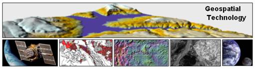
Joseph K. Berry
Keck Scholar in Geosciences,
Principal, Berry & Associates // Spatial Information Systems
Email jberry@innovativegis.com — Web www.innovativegis.com/basis/
Situation: Most desktop mapping and
Description: This intermediate level workshop discusses
and demonstrates several techniques for spatial analysis and data mining using
numerous examples from natural resources management, geo-business and precision
agriculture. The discussion focuses on
concepts, procedures and practical considerations in successfully applying
grid-based map analysis in
Who Should Attend:
 Joseph K. Berry is a leading consultant and educator in the application of Geographic
Information Systems (
Joseph K. Berry is a leading consultant and educator in the application of Geographic
Information Systems (
_______________________________________________________
Workshop Schedule
(Note:
times are approximate)
|
Time |
Topic |
|
|
Maps as Data ¾ Discrete map objects vs. continuous geographic space ¾ Grid data types, structures and display |
|
|
Surface Modeling ¾ Point density analysis ¾ Spatial interpolation ¾ Map comparison |
|
|
Spatial Data Mining ¾ Linking geographic and data space ¾ Map similarity ¾ Clustering mapped data ¾ Map regression ¾ Future geo-statistical tools |
|
|
Break |
|
10:30- 11:00am |
Spatial Analysis ¾ Fundamental classes of analytical operations ¾ Suitability mapping ¾ Measuring effective distance/connectivity |
|
|
Spatial Analysis (continued) ¾ Visual exposure analysis ¾ Analyzing landscape structure |
|
11:30- 12:00am |
¾ Modeling structure ¾ Processing hierarchy and analysis levels ¾ Calibrating and weighting model criteria ¾ Simulating alternative scenarios and perspectives |
Workshop Notes
Joseph K. Berry,
email jberry@innovativegis.com, website
www.innovativegis.com/basis
MapCalc
Applications at www.innovativegis.com/basis/Senarios/default.html
Map Analysis Book at www.innovativegis.com/basis/MapAnalysis/default.html
Cartography– manual map drafting (paper map legacy for thousands of years)
Computer Mapping– automates the cartographic process (70s)
Spatial Database Management– links computer mapping techniques with traditional database capabilities (80s)
Map Analysis and
ü
Surface
Modeling– maps the spatial
distribution of a set of point sampled data,
ü
Spatial Data
Mining– characterizes the “numerical”
relationships among mapped data and develops predictive models,
ü
Spatial
Analysis– derives new information
based on “contextual” relationships among mapped data,
ü
(See
Map Analysis, “Topic 4” for more information)
Raster refers to image display (map values represent the color assigned to each dot; e.g., scanned topographic maps–DRGs or aerial photos–DOQs) while Grid refers to map analysis (map values have all of the rights, privileges and responsibilities of a map-ematics).
Grid Data Structure the Analysis Frame
provides consistent “parceling” needed for map analysis and extends points,
lines and areas to Map Surfaces.
(See
MapCalc Applications, “Short Video Demos” for more information)
Shading Manager options include # of Ranges, Calculation
Method (e.g.,
Grid Display Types are Lattice that forms a smooth “wireframe” by connecting cell centroids with lines whose lengths are a function of elevation differences and Grid that forms extruded grids whose heights are a function of elevation differences.
Grid Data Types are characterized by their Numeric Distribution (independent integers versus range of values) and their Geographic Distribution (abrupt boundaries versus gradient). A Discrete map has values that simply represent categories (e.g., a covertype map) that form sharp abrupt boundaries) whereas a Continuous map has values that represent a spatial gradient (e.g., a slope map).
(See
Map Analysis, “Topic 18” for more information)
(See
MapCalc Applications, “Display Types” and “Data Types” for more
information)
Surface Modeling maps the spatial distribution and pattern of point data…
ü
Map
Generalization– characterizes spatial
trends (e.g., titled plane) by considering all of the samples at once as it
fits a surface,
ü
Spatial
Interpolation– derives spatial
distributions (e.g., IDW, Krig) by considering small, localized set of samples
throughout the map area (roving window), and
ü
Other– roving window/facets (e.g., density surface;
tessellation)
(See
Map Analysis, “Topics 2 and 8” for more information)
Data Mining investigates the “numerical” relationships in mapped data…
ü
Descriptive– calculates aggregate statistics (e.g.,
average/stdev, similarity, clustering) that summarize mapped data,
ü
Predictive– develops relationships among maps (e.g., regression)
that can be used to forecast characteristics or conditions at other locations
or times, and
ü
Prescriptive– uses descriptive and predictive information to
optimize appropriate actions.
(See
Map Analysis, “Topics 7 and 16” for more information)
Spatial Analysis investigates the “contextual” relationships in mapped data…
Reclassifying Maps– New map values are a function of the values on a single existing map… no new spatial information is created,
Overlaying Maps– New map values are a function of the values on two or more existing maps… new spatial information is created,
Measuring Distance– New map values are a function of the simple or weighted distance or connectivity among map features, and
Summarizing Neighbors– New map values are a function of the values within the vicinity of a location on an existing map.
(See
Map Analysis, “Topic 22” for more information)
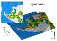
Measuring Distance– the concept of Distance as the “shortest straight line between two points” is expanded to Proximity by relaxing the assumption of only “two points” then expanded to Movement by relaxing the assumption of “straight-line” connectivity.
(See
Map Analysis book, “Topics 13, 14, 17, 19 and 20” for more information)
(See
MapCalc Applications, “Determining Proximity” and “Creating an
Calculating Visual Exposure– a Viewshed identifies all locations that can be seen from a view point(s) while Visual Exposure develops a relative scale indicating the number of times each location is seen from a set of viewer points, such as a road network.
(See
Map Analysis book, “Topic 15” for more information)
(See
MapCalc Applications, “Determining Visual Exposure” and “Modeling
Visual Exposure”)”
for more information)
Summarizing Neighbors– a Diversity Map indicates how many different types, a Roughness Map identifies the variation in slope values, and a Density Map reports the total value within a specified distance of each grid location.
(See
Map Analysis, “Topic 9” for more information)
(See
MapCalc Applications, “Assessing Covertype Diversity”)” for
ü
Statistical
Models– based on numerical
relationships (e.g., crop yield),
ü
Process Models– based on physical (e.g., erosion potential), and
ü
Suitability
Models– based on logically sequenced
decision criteria similar to a recipe (e.g, animal habitat)…
- Binary Model– identifies areas that are acceptable based on combining binary
maps (0 and 1),
- Ranking Model– develops a ranking of areas based on the number of criteria that
are acceptable (0 to 3), and
- Rating Model– develops a “goodness” scale (0 to 9 best) and calculates the
average rating for each grid cell.
(See
Map Analysis, “Topic 23” for more information)
________________________________________
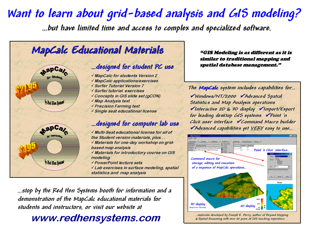
 MapCalc LearnerTM – Student Tutorial Version
(CD) with MapCalc and Surfer Tutorial
systems, Exercises/databases, application demos and text; 100x100
configuration; single seat license for educational use only; US$21.95 plus
shipping.
MapCalc LearnerTM – Student Tutorial Version
(CD) with MapCalc and Surfer Tutorial
systems, Exercises/databases, application demos and text; 100x100
configuration; single seat license for educational use only; US$21.95 plus
shipping.
(See www.redhensystems.com/mapcalc/ for more information)