GIS
Modeling in Education:
Approaches
and Materials for Instructors
GIS in the Rockies Conference
September 18, 2001, Denver, Colorado
…is GIS technology ahead of education?
 Presented by Joseph K. Berry
Berry& Associates, Fort Collins, Colorado
jberry@innovativegis.com
— 970-215-0825
SITUATION Desktop mapping has gained popularity in many disciplines
across campus. The additional dimension
of “where” has provided new approaches to data analysis and decision
formulation. However, instruction in
grid-based processing has been limited.
Until recently, GIS software supporting surface modeling, geo-statistics
and spatial analysis has been too expensive and too complex for all but
advanced courses. The full-day workshop provides tutorial software,
exercises/databases and teaching materials supporting an introductory course in
GIS Modeling.
WORKSHOP DESCRIPTION This intermediate level
workshop presents the basic concepts, procedures and applications of GIS modeling
with emphasis agriculture and resource
management. The concepts presented are
reinforced through several practical exercises. The first portion of the workshop establishes the concept of
“maps as data” by introducing the fundamentals of spatial statistics, with
emphasis on the considerations and issues surrounding interpolation of point
data. These discussions are extended to
surface modeling and mapped data analysis.
The next portion focuses on the analytical capabilities of GIS
emphasizing grid-based spatial analysis techniques. The discussion focuses on individual operations, such as
shape/pattern indices, effective distance, optimal path connectivity, visual
exposure and roving windows that are used in modeling spatial
relationships. These discussions are
extended to GIS modeling procedures required in constructing sound application
models and the future directions of GIS technology. Participants receive an evaluation copy of the MapCalc Learner CD consisting of
tutorial versions of Surfer (www.GoldenSoftware.com) for surface modeling and
MapCalc (www.redhensystems.com) for spatial statistics, analysis and modeling,
plus a basic set of exercises/databases and numerous application scenarios for
use in course development.
WHO SHOULD ATTEND Agriculture
and Natural Resource educators who are currently involved in the development of
academic programs in spatial data and
modeling. This is an intermediate level
workshop and prior GIS experience and familiarity with basic statistical
concepts are recommended.
WORKSHOP TOPICS
· Topic #1 —Maps as Data— establishes the fundamental concepts and procedures of spatial interpolation and surface analysis within a general “map-ematical” framework. Uses Surfer tutorial system to demonstrate several exercises in surface modeling. Introduction; Similarities and differences between vector and grid-based processing; Spatial interpolation; Grid math.
· Topic #2 —Map Analysis Capabilities— discusses individual spatial analysis operations, emphasizing, such as shape/pattern indices, effective distance, optimal path connectivity, visual exposure, and roving windows. Uses MapCalc tutorial system to demonstrate several exercises in Reclassify and overlay operations; Distance and connectivity operations; Neighborhood operations.
·
Topic #3 —Spatial
Modeling— describes procedures involved in
constructing sound application models.
Uses the MapCalc tutorial system to demonstrate several exercises in
GISD Modeling. Spatial reasoning; Flowcharting
model logic; Presentation graphics; Import/export.
ABOUT THE INSTRUCTOR
 Dr. Joseph K. Berry is president of Berry and
Associates // Spatial Information Systems, consultants and software developers
in Geographic Information Systems (GIS) technology. He also serves as Special Projects Manager for Red Hen Systems
and is the Keck Scholar at the University of Denver. He is the author of the Beyond Mapping column for GIS World, the
column Inside the GIS Toolbox for ag/Innovator and has written over two hundred
papers on the analytic capabilities of GIS.
He is the author of the popular books Beyond Mapping and Spatial
Reasoning and is involved in the development of Red Hen’s MapCalc
software system for grid-based map analysis.
He holds a B.S. degree in Forestry, a M.B.A. emphasizing operations
research and finance, and a Ph.D. in remote sensing and land use planning. See www.innovativegis.com for a
description of activities.
Dr. Joseph K. Berry is president of Berry and
Associates // Spatial Information Systems, consultants and software developers
in Geographic Information Systems (GIS) technology. He also serves as Special Projects Manager for Red Hen Systems
and is the Keck Scholar at the University of Denver. He is the author of the Beyond Mapping column for GIS World, the
column Inside the GIS Toolbox for ag/Innovator and has written over two hundred
papers on the analytic capabilities of GIS.
He is the author of the popular books Beyond Mapping and Spatial
Reasoning and is involved in the development of Red Hen’s MapCalc
software system for grid-based map analysis.
He holds a B.S. degree in Forestry, a M.B.A. emphasizing operations
research and finance, and a Ph.D. in remote sensing and land use planning. See www.innovativegis.com for a
description of activities.
SOFTWARE USED IN THE WORKSHOP
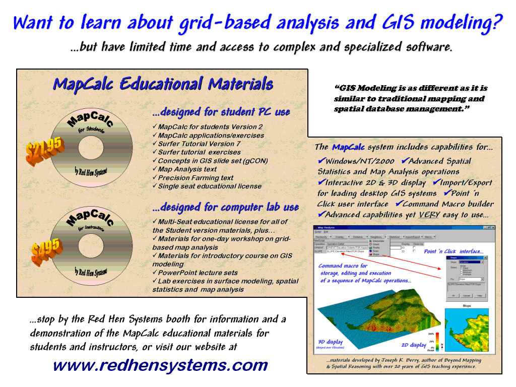 The MapCalc educational
system comes in two forms—the MapCalc Learner package for students and
the MapCalc Academic for instructors.
The Learner CD contains the MapCalc
and Surfer tutorial systems, exercises/databases, application demos and two
online text—Map Analysis, a compilation of Dr. Berry’s “Beyond Mapping”
column in GEOWorld. The MapCalc software by Red Hen Systems has extensive capabilities in spatial
analysis and statistics. The Surfer software by Golden Software provides extended capabilities in surface
modeling and 3-D graphics. The MapCalc
tutorial version is constrained to a 100x100 grid configuration (10,00 grid
cells) and some of Surfer’s output features are constrained in the tutorial
version. Both software systems have
data exchange tools and accept data for creating your own databases.
The MapCalc educational
system comes in two forms—the MapCalc Learner package for students and
the MapCalc Academic for instructors.
The Learner CD contains the MapCalc
and Surfer tutorial systems, exercises/databases, application demos and two
online text—Map Analysis, a compilation of Dr. Berry’s “Beyond Mapping”
column in GEOWorld. The MapCalc software by Red Hen Systems has extensive capabilities in spatial
analysis and statistics. The Surfer software by Golden Software provides extended capabilities in surface
modeling and 3-D graphics. The MapCalc
tutorial version is constrained to a 100x100 grid configuration (10,00 grid
cells) and some of Surfer’s output features are constrained in the tutorial
version. Both software systems have
data exchange tools and accept data for creating your own databases.
More
information at…
![]()
![]()