 |
|
|
|
|
|
|
|
|
|
|
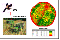
Precision Ag Data Analysis
|
|
|
|
|
|
|
|
|
|
|
|
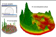
Surface modeling maps the
spatial distribution and pattern of point data…
|
|
|
ü |
Map
Generalization— characterizes spatial trends
(e.g., titled plane)
|
|
|
|
ü |
Spatial Interpolation— deriving
spatial distributions (e.g., IDW, Krig)
|
|
|
|
ü |
Other— roving
window/facets (e.g., density surface; tessellation)
|
|
|
|
|
|
 |
|
|
 |
|
|
|
|
|
|
|
|
|
|
|
|
Spatial statistics investigates
the “numerical” relationships in mapped data…
|
|
|
|
ü |
Descriptive—
aggregate statistics (e.g., average/stdev, similarity,
clustering)
|
|
|
ü |
Predictive— relationships
among maps (e.g., regression)
|
|
|
|
ü |
Prescriptive—
appropriate actions (e.g., optimization)
|
|
|
|
|