|
The Precision Farming Primer |
|
|
|
An Overview of Precision Farming
-- introduces spatial relationships as the basis of precision farming
Underlying
Principles -- describes the difference between whole-field and
site-specific farming
Unusual
Blend of technologies -- introduces the technologies supporting
precision farming
Processing Precision Farming Data
-- identifies the different levels in precision farming
Technical
Issues -- introduces the four steps of the precision farming process
Current Reality and Future
Directions -- looks at the opportunities of site-specific management
(Back to the Table of Contents)
______________________________
An Overview of Precision
Farming (return to top of
Introduction)
To many, precision farming might appear an oxymoron. With mud up to axles and 400 acres left to plow, precision seems worlds away. Yet site-specific management makes sense to a rapidly growing number of farmers as years of experience confirm the variability in field conditions and yield. Mapping and analyzing this variability and linking the spatial relationships to management action places production agriculture at the cutting edge of GIS applications. Its use down on the farm is both down to earth and downright ambitious.
Underlying Principles (return to top of
Introduction)
Until the 1990s maps played a minor role in
production agriculture. Soil maps and topographic sheets, for the most part,
were too generalized for application at the farm level. Acquisition of spatial
data with the detail and information farmers needed for operations were beyond
reach. The principle of whole-field management, based on broad averages
of field data, dominated management actions. Weigh-wagon, or grain elevator
measurements, established a field’s yield performance. Soil sampling determined
the typical nutrient levels within a field. From these and other data the best
overall seed variety was chosen and a constant rate of fertilizer applied, as
well as a bushel of other decisions—all treating the entire field as uniform
within its boundaries.
Site-specific management, on the other hand, recognizes the
variability within a field and is about doing the right thing, in the right
way, at the right place and time. It involves assessing and reacting to
field variability by tailoring management actions, such as fertilization
levels, seeding rates and variety selection, to match changing field
conditions. It assumes that managing field variability leads to both cost
savings and production increases, as well as improved stewardship and
environmental benefits.
Unusual Blend of Technologies (return to top of
Introduction)
Site-specific farming isn’t just a bunch of
pretty maps, but a set of new technologies and procedures linking mapped
variables to appropriate management actions. It requires the integration of
several key elements: the global positioning system
(GPS), on-the-fly
data collection devices, geographic information systems (GIS) and variable-rate implements. Modern GPS receivers are able to establish positions within a field
to about a meter. When connected to a data collection device,
such as a yield/moisture meter, these data can be "stamped" with
geographic coordinates. Several portable "heads-up" digitizing
devices allow farmers to sketch conditions, such as weed infestations, on a map
or aerial photo backdrop. A GIS is used to map the field data so a
farmer can see the conditions throughout a field. The GIS also can be used to
extend map visualization of yield to analysis of the relationships among yield
variability and field conditions. Once established these relationships are used
to derive a "prescription" map of management actions required for
each location in a field. The final element, variable rate
implements, notes a tractor’s position through GPS, continuously locates it
on the prescription map, then varies the application rate of field inputs, such
as fertilizer blend or seed spacing, in accordance with the instructions on the
prescription map. Combining the technologies of GPS, GIS and intelligent devices and implements (IDI) provides the mechanisms for managing field
variability. The maturation and commercialization of these technologies have
made the concept practical.
Processing Precision Farming Data (return to top of
Introduction)
To date, most analysis has been visual
interpretations of yield maps. By viewing a map, all sorts of potential
relationships between yield variability and field conditions spring to mind.
These "visceral visions " and explanations can be drawn through the viewer’s
knowledge of the field. More recently, data visualization is being extended
through map analysis at three levels: cognitive, analysis and synthesis.
The foundation of precision farming occurs at
several levels:
- cognitive
- analysis
- synthesis
The cognitive level manages and stores
mapped data on the desktop. The analysis level discovers relationships
among the mapped variables, such as yield and soil nutrient levels. This step
is analogous to a farmer’s visceral visions of relationships but uses the computer
to establish more detailed mathematical and statistical connections. Although
this step is somewhat an uncomfortable "leap of scientific faith," it
extends data visualization by investigating the coincidence of the patterns of
variation among a set of maps. The results relate yield goals to specific
levels of farm inputs—traditional agricultural research, but tailored to a
farmer’s "backyard."
The synthesis level evaluates newly
derived relationships to formulate management actions for a new location
(change in space) or another year at the same place (change in time). The
result is a prescription map used to guide the intelligent implements as they
"variable rate control" the application of field inputs. Or, the
analysis might discover an area of abnormally low yield as aligning with a
section of old drainage tile in need of repair. Further analysis might locate
areas whose simulated yield increases under drier conditions justify
installation of additional drainage tiles.
Technical Issues (return to top of
Introduction)
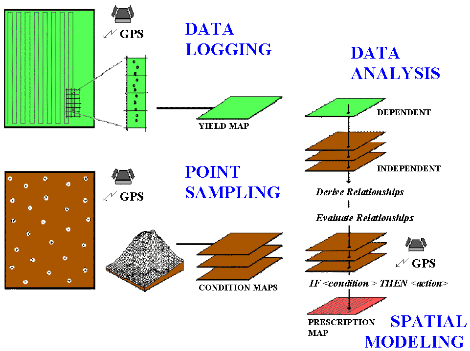
The precision farming process can be viewed
as four steps: data logging, point sampling, data analysis and spatial modeling
(see fig. 0.1). Data logging continuously monitors measurements, such as
crop yield, as a tractor moves through a field. Point sampling, on the
other hand, uses a set of dispersed samples to characterize field conditions,
such as phosphorous, potassium, and nitrogen levels. The nature of the data
derived by the two approaches are radically different— a "direct
census" of yield consisting of thousands of on-the fly samples versus a
"statistical estimate" of the geographic distribution of soil
nutrients based on a handful of soil samples.
|
|
|
Figure 0.1. Flowchart of the precision farming process. |
In data logging, issues of accurate
measurement, such as GPS positioning and material flow adjustments, are major
concerns. Most systems query the GPS and yield monitor every second, which at 4
mph translates into about 6 feet. With differential positioning the coordinates
are accurate to about a meter. However the paired yield measurement is for a location
well behind the harvester, as it takes several seconds for material to pass
from the point of harvest to the yield monitor. To complicate matters, the mass
flow and speed of the harvester are constantly changing when different terrain
and crop conditions are encountered. The precise placement of GPS/Yield records
are not reflected as much in the accuracy of the GPS receiver as in
"smart" yield mapping software.
In point sampling, issues of surface modeling
(estimating between sample points) are of concern, such as sampling
frequency/pattern and interpolation technique. The cost of soil lab analysis
dictates "smart sampling" techniques based on terrain and previous
data be used to balance spatial variability with a farmer’s budget. In addition,
techniques for evaluating alternative interpolation techniques and selecting
the "best" map using residual analysis are available in some of the
soil mapping systems.
In both data logging and point sampling, the
resolution of the analysis grid used to geographically summarize the data is a
critical concern. Like a stockbroker’s analysis of financial markets, the
fluctuations of individual trades must be "smoothed" to produce
useful trends. If the analysis grid is too course, information is lost in the
aggregation over large grid spaces; if too small, spurious measurement and
positioning errors dominate the information.
The technical issues surrounding mapped
data analysis involve the validity of applying traditional statistical
techniques to spatial data. For example, regression analysis of field plots has
been used for years to derive crop production functions, such as corn yield
(dependent variable) versus potassium levels (independent variable). In a GIS,
you can use regression to derive a production function relating mapped
variables, such as the links among a map of corn yield and maps of soil
nutrients—like analyzing thousands of sample plots. However, technical
concerns, such as variable independence and autocorrelation, have yet to be
thoroughly investigated. Statistical measures assessing results of the
analysis, such as a spatially responsive correlation coefficient, await
discovery and acceptance by the statistical community, let alone the farm
community.
In theory, spatial modeling
moves the derived relationships in space or time to determine the
"optimal" actions, such as the blend of phosphorous, potassium and
nitrogen to be applied at each location in the field. In current practice,
these translations are based on existing science and experience without a
direct link to data analysis of on-farm data. For example, a prescription map
for fertilization is constructed by noting the existing nutrient levels
(condition) then assigning a blend of additional nutrients (action) tailored to
each location forming a if-(condition)-then-(action) set of rules. The
issues surrounding spatial modeling are similar to data analysis and involve
the validity of using traditional "goal seeking" techniques, such as
linear programming or genetic modeling, to calculate maps of the optimal
actions.
Current Reality and
Future Directions (return to top of
Introduction)
The application of GIS within production agriculture
has been rapid. Since its inception in the early 90s, precision farming has
moved from a fledgling idea to operational reality on millions of acres. Its
current expression emphasizes the generation of yield maps by linking GPS with
on-the-fly yield monitors. Valuable insight is gained by visualizing field
variability, particularly when yield maps for several years are considered.
More advanced applications include analysis of soil nutrient maps to derive a
prescription map used in variable rate control of fertilizer, terrain analysis
for variable seeding rates and spatial modeling for timing and spot application
of herbicides/pesticides.
The infrastructure for precision farming is
coming online. Most manufacturers offer precision farming options with their
farm vehicles and implements. A growing number of service providers offer
advice to farmers in their adoption of the new technology. At present, however,
a full implementation of precision farming is in the hands of the developers
and researchers. Advancements in the data analysis and spatial modeling phases
await contributions from the GIS community. The considerable knowledge and
methodologies of the agricultural science community need to be reviewed for
their spatial inferences. Opportunities abound in one of GIS’s more important
applications and we all benefit from precision farming’s fruits—check it out at
your local super market.