|
The Precision Farming Primer |
|
|
|

What’s Next in GIS on the
Farm?
(return
to the Table of Contents)
What’s Next in GIS on the Farm? (return to top)
In
many respects, technology is as ingrained in farming as it is in the service,
industrial and government sectors—maybe more.
Antennas sprout from tractor cabs, pickups and silos. Computers are spreading like weeds from the
old recreation room turned office into the barn, pastures and fields. The cyber tentacles even reach into the
breast pocket of many information-age farmers.
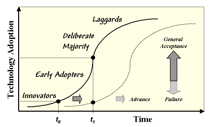 Figure 1.
Dimensions in Technology Adoption.
Figure 1.
Dimensions in Technology Adoption.
Keep
in mind that there are several dimensions to the adoption of technology. It takes hold over time and moves through
different potential user groups—innovators, early adopters, deliberate
majority and laggards. At any
instant there are varying degrees of adoption within the general
community. About the time the majority
fully engages a new technology the innovators are launching another one. For example, as yield mapping gains
acceptance the innovators are moving into prescription mapping.
This
cycle has been with agriculture since its inception when the stick, fish head
and seed in a hole was replaced by a hand plow.
What seems to have changed is the speed and breadth of the cycle. As the information age takes hold on the farm
the changes seem relentless. But
potentially more important is the unfamiliar breadth and complexity of the
changes.
While
the cell phone may revolutionize communication on the farm it builds on
familiar technology spawned from the hand-crank party line. Computer-based technology, on the other hand,
has some conceptual roots in scrapes of paper and accounting books but there is
a practical chasm between paperwork, digital records and spatial data.
The
application of mapped data in farm decision-making is unprecedented and GIS
technology is hobbled from the get-go.
While the innovators and early adopters have made tremendous advances in
site-specific agriculture, the industry hasn’t run the accelerating part of the
adoption curve. There are four factors
at work in determining “what’s next in GIS on the farm” —education, economics,
enlightenment, and environment.
Education casts the broadest
net. While most producers’ experience
is based in grease and gears the future raises the ante to megahertz and
gigabytes. The information age seems to
value data and communications almost as much as the crop itself. Identity preservation and crop records will
become increasingly important in meeting marketplace demands. A spin-off is an increased familiarity of
service providers and producers with computers and electronic devices—the
informational foundation of precision farming.
The sprouting of agricultural data warehouses helps lower the
educational bar and provide needed support.
Economics
serves
as the lubricant for technology adoption.
A common sense argument and an intellectual challenge are enough to
capture the attention of innovators, but numerous and convincing studies of
economic benefit are required to persuade the majority. The agricultural technology community needs
to join forces and underwrite such objective studies as a means to cross the
chasm from innovators to the majority of producers.
Enlightenment
couples
technology with science. In a sense we
have the technology cart in front of the science horse. GPS-enabled devices provide positioning. Remote sensing imagery provides timely views
of crop condition. GIS technology
provides a framework for assembling and analyzing all of the information. What’s missing is the science cornerstone
that investigates the spatial relationships, generates definitive procedures
and translates them into sound management actions.
Environment is the trump card. Stewardship of the land is in many respects
the ultimate bottom line in agriculture.
Environmental compliance requirements are greater than ever and increasingly
they are being spatially expressed.
Forestry’s initial flirtation with GIS technology in the 1980s was
sparked by a focus on economic gains but was overshadowed in the 1990s by
stewardship applications. Today,
environmental compliance for a harvest block involves watershed-wide mapping
and map analysis that assesses the impacts before a single tree is cut. Furthermore, wood products must receive
certification of coming from lands managed under a sustained forest plan before
a board is sold at Home Depot—external pressure from the marketplace as well as
regulation.
The
trajectory of the factors affecting GIS on the farm suggests an increasing
influence of GIS technology. The
ultimate form of agriculture’s expression awaits evolution but given that the
long run crystal ball is a bit hazy, we are we now in precision farming?
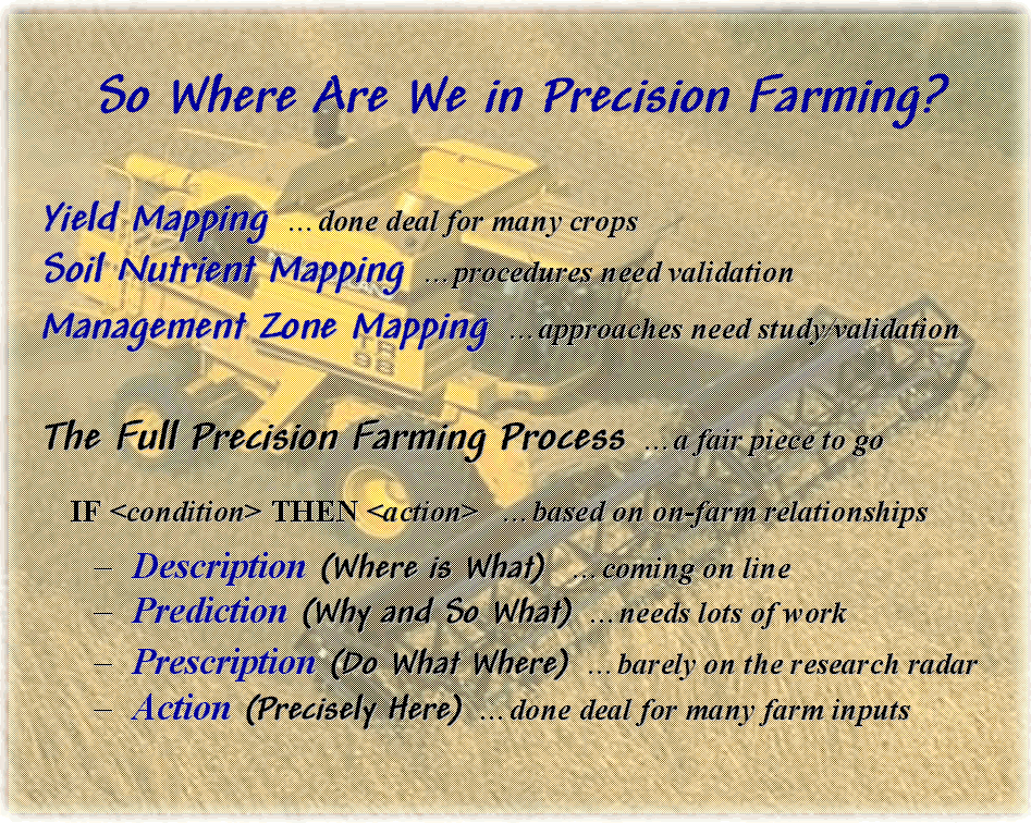 Figure 2. The
status of GIS applications varies from operational to in-process to visionary.
Figure 2. The
status of GIS applications varies from operational to in-process to visionary.
Three
agronomic applications are well underway—yield mapping, soil nutrient
mapping and management zone mapping.
Yield
mapping within
a decade has evolved from an idea to operational reality. However, two important refinements are
pending—monitor type and lag time adjustment. Current monitors are designed for measuring
“quantity” yet concern for mapping “quality” is rising. Software advances for correcting harvester’s
lag time involved in moving material from the cutting-head to the monitor
should greatly improve the positional accuracy of yield maps.
Soil
nutrient mapping is based on established procedures in spatial statistics. What remains is validation of the procedures
in this application and discovery of appropriate algorithms and sampling
designs. Also, the assumption of spatial
variability in nutrients needs to be investigated in three dimensions—soil
profile samples as well as whole-core samples.
Management
zone mapping seeks to subdivide a field into parts that are similar to each other
but different among groupings. The idea
is that the partitions better respond to tailored management decisions, such as
fertilization rates, than to whole-field averages. Early attempts based the delineations on
manual interpretation of aerial imagery and farmer experience alone. Current approaches using well-established
“data clustering” procedures meld additional data layers and bring spatial
statistics into the picture. What waits
is validation of the zones produced and discovery of which map sets and procedures
are best.
Yield,
soil nutrient and management zone mapping are near term endeavors that should
move precision farming from the innovators to the majority… provided education,
economics and enlightenment warrant the move.
The environment factor redirects GIS from a crop productivity focus to
one of stewardship communication and compliance.
The
bigger picture of the full precision farming process will take
longer to play out. The equipment and
procedures for the descriptive (where is what—sampling and monitors) and
action (precisely here—variable rate implements) are near reality. However, the prediction (so what and
why—data analysis) and prescription (do what where--optimization)
elements require considerable infusion of science. By its very nature agricultural science takes
time and sizeable number of growing seasons.
While
sufficient in the near term, the current science base is non-spatial and too
aggregated to realize precision farming’s full potential. The spatial variability within a field, among
farms and across regions is large and complex.
The structure of agricultural research will have to change to refocus
from considering average field conditions to mapping variations and
recommendations. Since each farm
represents a unique combination of spatial patterns (micro-terrain, soil
texture, soil nutrients, weeds, pests, etc.) on-farm studies will become
increasingly important.
GIS
technology will serve as the engine for collecting, storing and analyzing the
new round data. Chances are tomorrow’s
farm will be valued for its information base, as well as its productivity
base—a reality spawned by agriculture’s part of the information-age.