| Delineating
Zones |
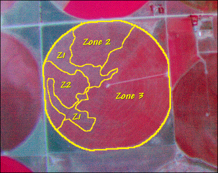
| Visible
differences in |
||||||||||
| an aerial
image can |
||||||||||
| be used to
delineate |
||||||||||
| portions of
a field |
||||||||||
| that have
consistent |
||||||||||
| texture and
color |
||||||||||
| (Management
Zones). |
||||||||||
| The zones are |
||||||||||
| assumed to
have |
||||||||||
| consistent
levels for |
||||||||||
| each of the
field’s |
||||||||||
| driving
variables |
||||||||||
| (uniform
conditions) |
||||||||||
| (Wright & Berry) |