…the following
is from a two-part series on Video/Image mapping appearing in the “Beyond
Mapping” column by Joseph K. Berry, GEOWorld
online issues for September and October, 2000
(Vol. 13, NO. 9-10).
The information is intended to describe the
conceptual approach, considerations and practical applications of video
mapping. Several online demonstrations
of this emerging technology in a variety of applications are available at http://www.redhensystems.com. For information on the VMS 200TM
Video Mapping System contact Red Hen Systems, Inc, 2310 East Prospect Road,
Suit A, Fort Collins, USA 80525, Phone: (800) 237-4182, Email: info@redhensystems.com
Click here for a
printable version of this paper (.pdf document)
_______________________
Capturing "Where and
When" on Video
(GeoWorld online September, 2000)
The
past several columns described procedures for translating
An
alternative is to populate a
Video
mapping is
an exciting part of the revolution in visualization of mapped data. It records
With
video mapping, the construction of a multimedia
During
the Recording Step, video mapping encodes
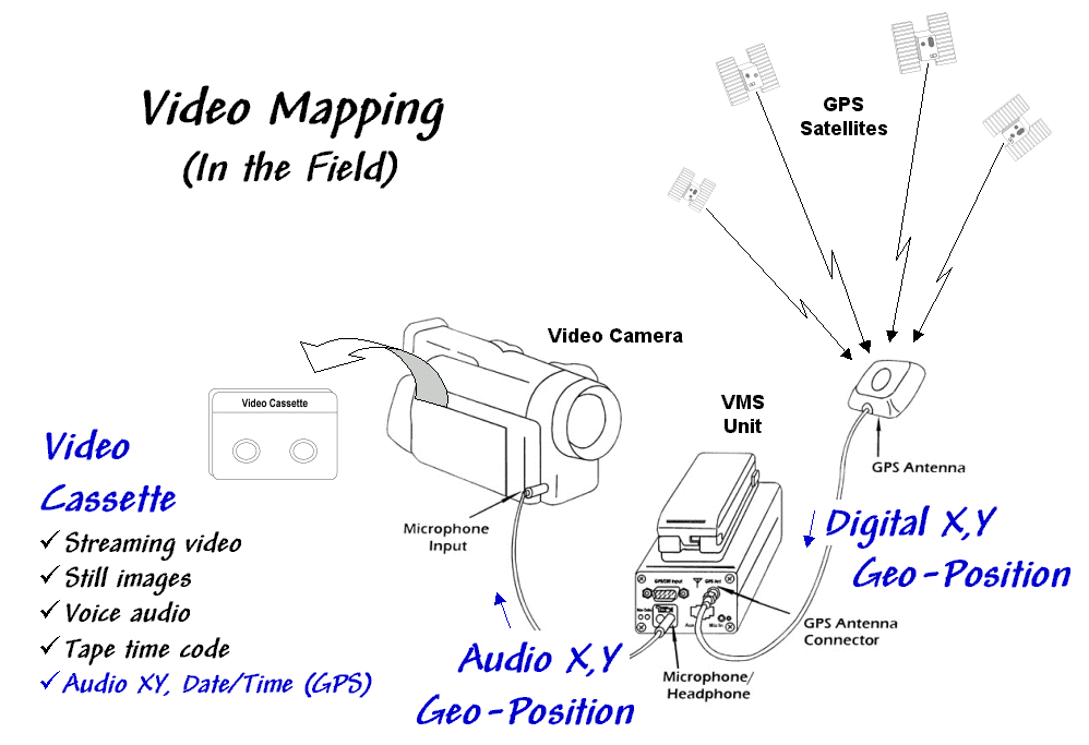
Figure 1.
Video Mapping in the Field. As video is recorded, the
precise location, time, and
date are recorded every
second to one of the videotape’s audio tracks.
The other track records
pertinent information as you speak.
In
turn, the acoustic signals are sent to one of the audio channels through the
microphone input connector on the video camera.
The result is recording the
The
direct recording of “where and when” on the tape greatly facilitates field data
collection—as long as there is
Most
contemporary video cameras have a switch between photo and movie mode. In movie mode, streaming video is recorded at
30 frames per second. In photo mode, the
camera acts like a still camera and "freezes" the frame for several
seconds as it records the image to videotape.
In this mode, a one-hour videotape can record over 500 digital pictures. In both photo and movie modes the one-second
The
Indexing Step involves connecting the video mapping unit to a
computer and playing the video (see figure 2). In this configuration, the audio cord is
switched to the Headphone Output connector and a second cable is
connected to the Lan C connector on the camera.
The connector provides information on tape position (footage on older
cameras and time code on newer ones) used in indexing and playback control of
the tape similar to those on a standard
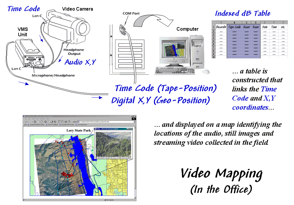
Figure 2. Indexing the Videotape. The video, audio notes and
to construct a multimedia map of the precise position
and date/time
of the video footage providing direct retrieval of
text, data, audio,
image and video by simply clicking on the map.
As
the videotape is played, the audio X,Y and time code information is sent
to the video mapping unit where it is converted to digital data and sent to the
serial port on the computer. If a
headset was used in the field, the voice recording on the second audio channel
is transferred as well.
For
indexing there are five types of information available—streaming video (movie
mode), still images (photo mode), voice audio (headset), tape time code (tape
position), and
Video
mapping software records the
The Review Step
uses the indexed database to access audio and video information on the
tape. The hardware configuration is the
same as for indexing (audio, Lan C and serial cables). Clicking on any indexed location retrieves its
Map
features can start applications, open files and display images. The software works with video capture cards
to create still images and video clips you can link to map features, giving
maximum flexibility in choosing a data review method. In many applications the completed multimedia
map is exported as an HTML file for viewing with any browser or over the
Internet. The map features can contain
any or all five
of the basic information types:
ü Text — interpreted from audio as
.
ü Data — interpreted from audio as
.DAT, .XLS or .DBF file
ü Audio — captured as .WAV file
(about 100KB per 5 seconds)
ü Image — captured as .JPG file
(about 50KB per image)
ü Video — captured as .
Next month’s column explores the
procedures for constructing finished maps and describes several applications of
video mapping. In the interim, you might
checkout the links to some online examples (see author’s notes).
_________________________________
Creating Interactive Video
Maps
(GeoWorld online October, 2000)
As detailed in last month’s column, video
mapping enables anyone with a computer and video camera to easily create their
own interactive video maps. The
integration of computers, video camera, and
For example, corridor mapping of oil and gas
pipelines, transmission towers, right of ways and the like provide images of
actual conditions not normally part of traditional maps. In law enforcement, video mapping can be used
from reconnaissance to traffic safety to forensics. Agriculture applications include crop scouting,
weed/pest management, verification of yield maps, and “as-applied”
mapping. Geo-business uses range from
conveying neighborhood character, to insurance reporting to web page
development.
By coupling audio/visual information to other
Data is collected without a computer in the
field or cumbersome additional equipment.
Figure 1 shows the VMSTM unit by Red Hen Systems (see
author’s note) that weighs less than a pound and is connected to the video
camera via a small microphone cable. The
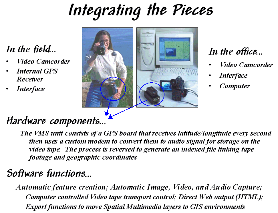
Figure 1. Video Mapping Hardware. The VMS 200 unit enables
recording and processing
of
The office configuration consists of a video
camera, VMS unit, notebook or desktop computer, and mapping software. The software generates a map automatically
from the data recorded on the videotape.
Once a map is created, it can be personalized by placing special feature
points that relate to specific locations.
These points are automatically or manually linked to still images, video
clips, sound files, documents, data sets, or other actions that are recalled at
the touch of a button. A voice
recognition package is under development that will create free-form text and
data-form entry. The mapping software
also is compatible with emerging
While a map is being created, or at a later
time, a user can mark special locations with a mouse-click to
"capture" still images, streaming video or audio files. The “fire wire” port on many of the newer computers
makes capturing multimedia file a snap.
Once captured, a simple click on the map feature accesses the images,
associated files, or video playback beginning at that location.
Sharing or incorporating information is easy
because the video maps are compatible with
most popular
Differential post-processing is another
important software addition. The
post-processing software (EZdiffTM) takes base station correction
data from the Internet and performs a calculation against the video mapped
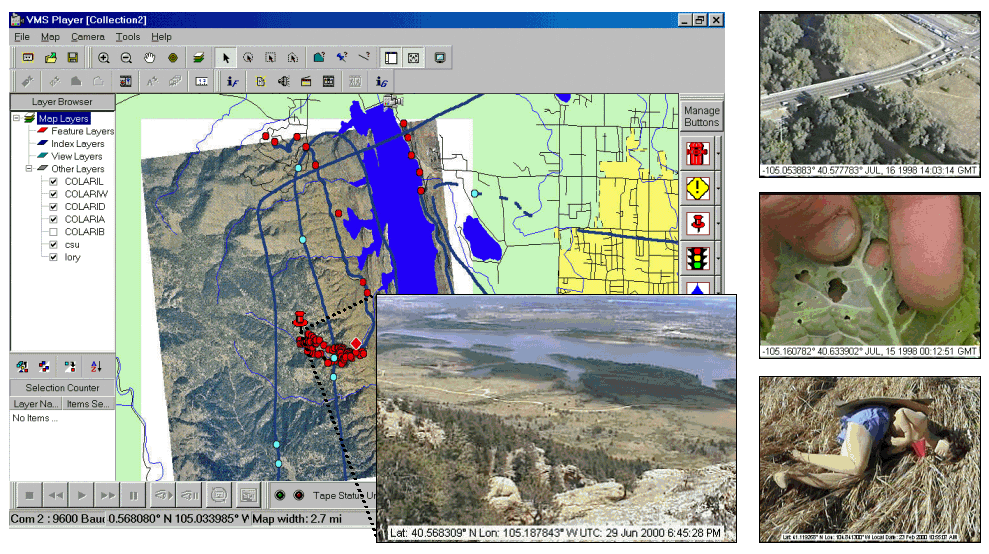
Figure 2.
Video Mapping Software. Specialized software builds a linked database
and provides
numerous features for
accessing the data, customizing map layout and exporting to a variety of
formats.
Figure 2 shows an example of the video mapping
software. The dark blue line on map
identifies the route of an ultralite (a hang-glider with an engine). Actually the line is composed of a series of
dots— one for each second the video camera was recording. Clicking anywhere on the line will cause the
camera, or
The light blue and red dots in the figure are
feature locations where still images, audio tracks and video clips were
captured to the hard disk. The larger
inset is a view of the lake and city from the summit of a hiking trail. The adjacent red dots are a series of similar
images taken along the trail. When a
video camera is set in photo mode, a one-hour videotape contains nearly 600
exposures— no film, processing or printing required. In addition, the automatic assignment of
The top captured image on the right side of the
figure shows a photo taken from an ultralite inventory of bridges along a major
highway. The middle image is a field
photo of cabbage loper damage in a farmer’s field. The bottom image is of a dummy in a training
course for police officers. The web
pages for these and other applications are online for better understanding of
video mapping capabilities (see author’s notes).
For
centuries, maps have been abstractions of reality that use inked lines, symbols
and shadings to depict the location of physical features and landscape
conditions. Multimedia
____________________________________
Author’s Notes: An online demo of
MediaMapper HTML export as a webpage of an ultralite flight and hiking photos
of the Horsetooth,
http://www.innovativegis.com/basis/misc/misc.htm
The pMAP and aMAP software packages and educational
materials have been enhanced and upgraded for Windows; now available as MapCalc Learner for students
and MapCalc Academic for instructors.