Applying MapCalc Map Analysis Software
Mapping Wildfire Response: The on- and off-road response-time
throughout a project area is need for county-wide emergency planning and fire
risk modeling. The initial response model
considers on-road and off-road travel depending on terrain and land cover
conditions.
<click
here> for a printer friendly
version (.pdf)
Processing Flow.

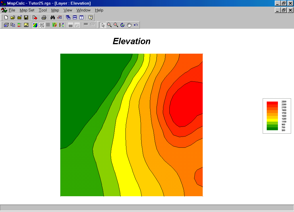
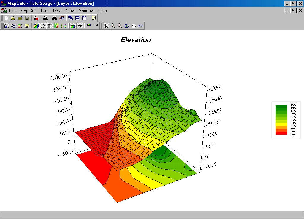
Base Maps. The Base Maps needed include:
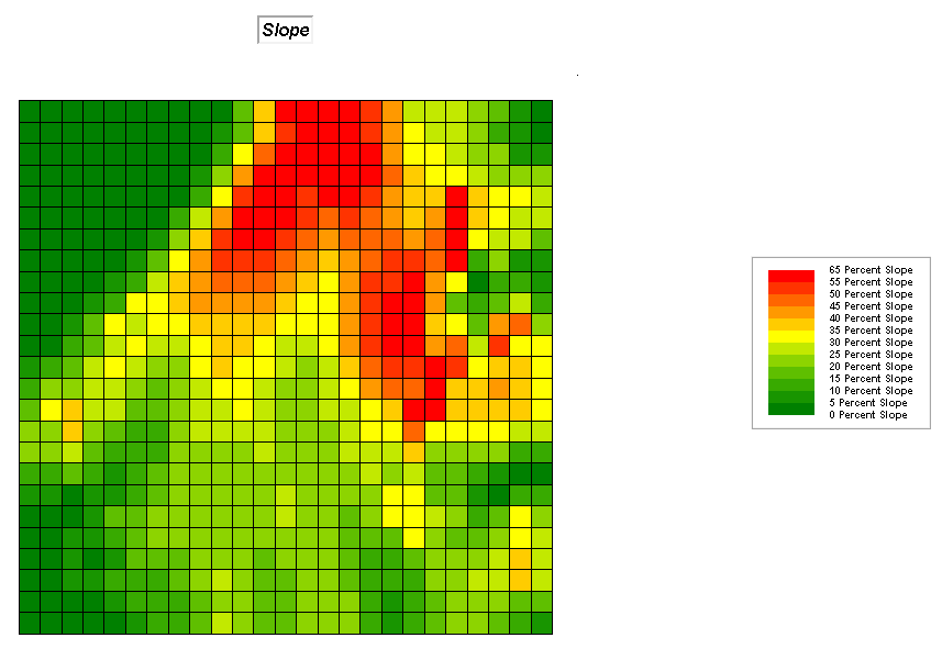 Slope map. Each grid cell value identifies terrain
steepness.
Slope map. Each grid cell value identifies terrain
steepness.
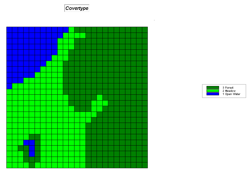 Covertype Map. Each grid cell value identifies land
cover.
Covertype Map. Each grid cell value identifies land
cover.
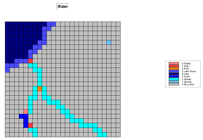 Water Map. Each grid cell value identifies surface water
present.
Water Map. Each grid cell value identifies surface water
present.
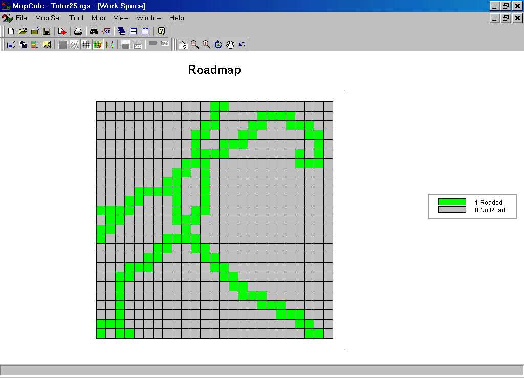
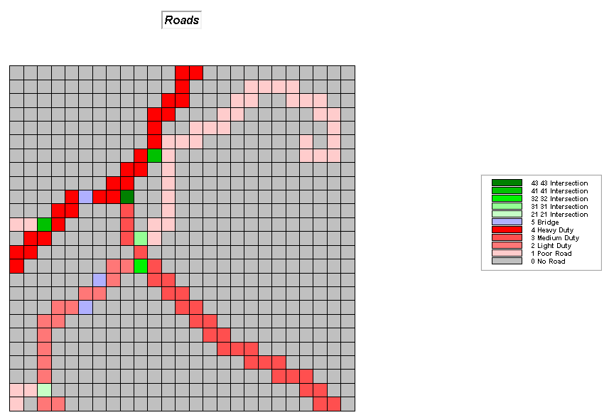 Roads Map. Each grid cell value identifies the type of
road present.
Roads Map. Each grid cell value identifies the type of
road present.
![]() Step 1, On-road travel. The “on-road travel” step calibrates the Roads
map with the base unit of effective distance as 1= .1 minute for
crossing a Primary road cell (Road map value 4 assigned a new value of 1). The remaining road types are assigned
relative impedance values…
Step 1, On-road travel. The “on-road travel” step calibrates the Roads
map with the base unit of effective distance as 1= .1 minute for
crossing a Primary road cell (Road map value 4 assigned a new value of 1). The remaining road types are assigned
relative impedance values…
RENUMBER Roads ASSIGNING 10 TO
1 ASSIGNING 5 TO 2 ASSIGNING 2 TO 3 ASSIGNING 1 TO 4 ASSIGNING 5 TO 5 ASSIGNING 15 TO 21 THRU 43 FOR On_road
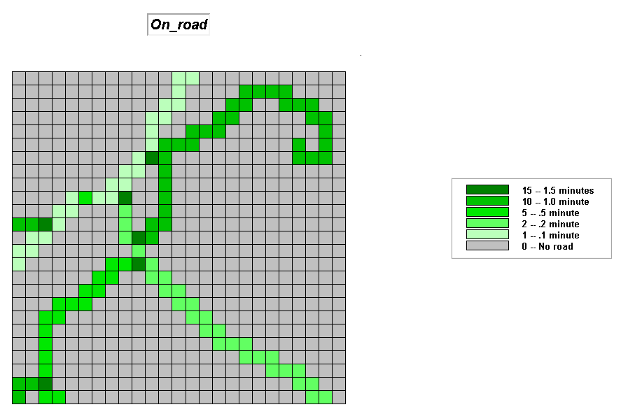 On_road Map.
 Step 2, Off-road relative barriers. The “off-road
relative barriers” step considers the relative ease of travel depending on the
slope and cover type present. First, the
Slope map is divided into three classes (1= 0 to 10 %slope= gentle;
2= 10 to 30%slope= moderate; 3= 30 to 65%= steep)…
Step 2, Off-road relative barriers. The “off-road
relative barriers” step considers the relative ease of travel depending on the
slope and cover type present. First, the
Slope map is divided into three classes (1= 0 to 10 %slope= gentle;
2= 10 to 30%slope= moderate; 3= 30 to 65%= steep)…
RENUMBER Slope ASSIGNING 1 TO 0 THRU 10 ASSIGNING
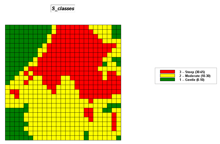 S_classes Map.
Next, the Covertype map and the S_classes map are combined to form a 2-digit code with the cover type
indicated by the first (ten’s) digit and the slope class by the second (one’s)
digit…
COMPUTE Covertype Times 10 Plus S_classes FOR Combo
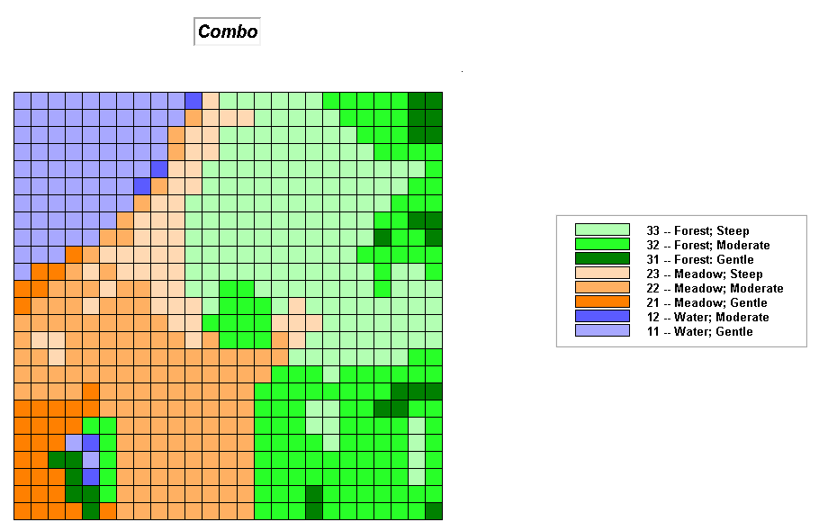 Combo Map.
Then calibrate the Combo map for relative ease of off-road travel…
RENUMBER Combo ASSIGNING 0 TO 11 ASSIGNING 0 TO 12 ASSIGNING 0 TO 13 ASSIGNING 15 TO 21 ASSIGNING 20 TO 22 ASSIGNING 25 TO 23 ASSIGNING 20 TO 31 ASSIGNING 30 TO 32 ASSIGNING 40 TO 33 FOR Off_relBarriers
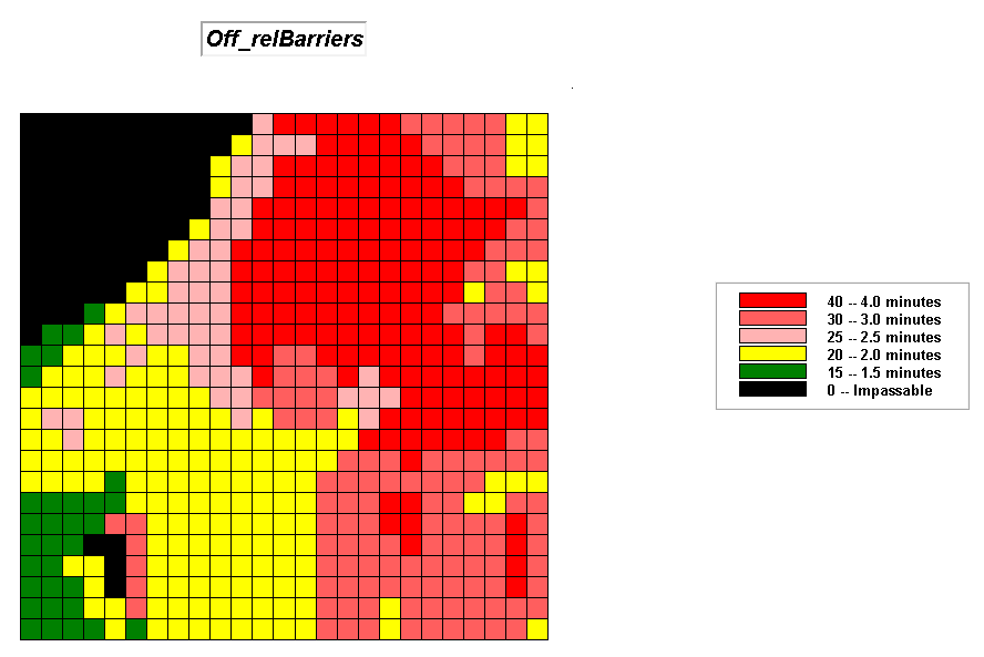 Off_relBarriers Map.
 Step 3,
Off-road absolute barriers. The “off-road absolute barriers” step identifies locations
that the response vehicle cannot go as zero (surface water and very steep
terrain) and locations that are passable as one. First the “binary” Water map is established…
Step 3,
Off-road absolute barriers. The “off-road absolute barriers” step identifies locations
that the response vehicle cannot go as zero (surface water and very steep
terrain) and locations that are passable as one. First the “binary” Water map is established…
RENUMBER Water ASSIGNING 1 TO 0 THRU 1 ASSIGNING 0 TO 2 THRU 8 FOR W_absBarriers
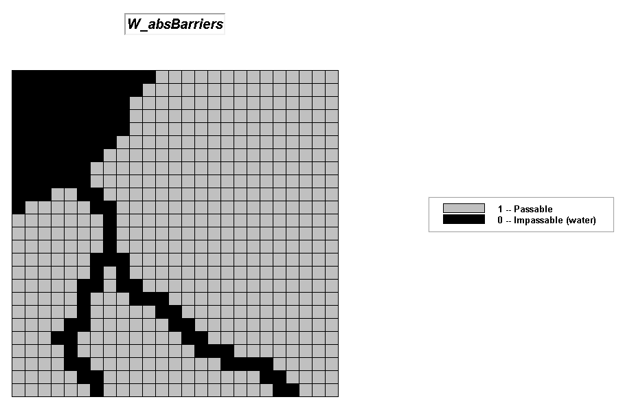 W_absBarriers Map.
Then the “binary” Slope map is established…
RENUMBER Slope ASSIGNING 1 TO 0 THRU 50 ASSIGNING 0 TO 50 THRU 65 FOR S_absBarriers
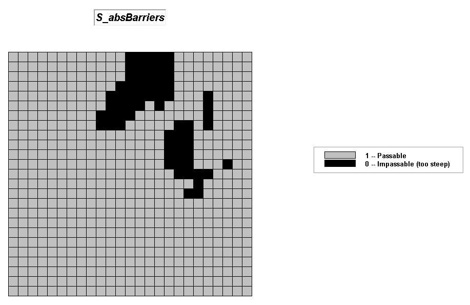 S_absBarriers Map.
 Step 4, Off-road travel (overall). The “off-road
travel” step uses binary mathematics to set the no-go areas to zero while
retaining the relative barriers to travel for accessible areas.
Step 4, Off-road travel (overall). The “off-road
travel” step uses binary mathematics to set the no-go areas to zero while
retaining the relative barriers to travel for accessible areas.
COMPUTE Off_relBarriers Times W_absBarriers Times S_absBarriers FOR Off_road
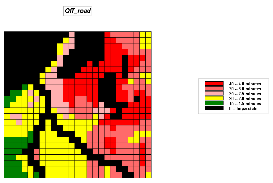 Off-road Map.
 Step 5, Combine on/off-road
travel. The
“combine on/off-road travel” step uses a point by point overlay technique to
update (replace) the off-road information for the areas with on road impedance
information
Step 5, Combine on/off-road
travel. The
“combine on/off-road travel” step uses a point by point overlay technique to
update (replace) the off-road information for the areas with on road impedance
information
COVER Off_road WITH On_road FOR Friction
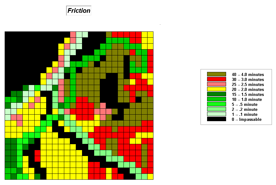 Friction Map.
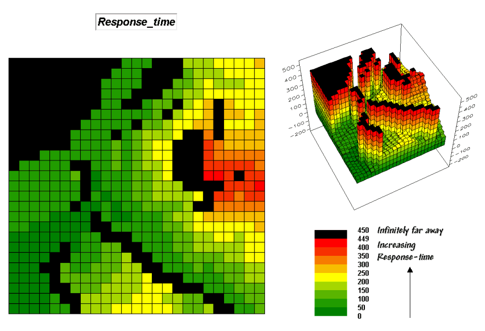
 Step 6, Calculate response-time. The “calculate
response-time” step uses the Spread command to determine the effective
proximity from the ranch to all locations in the project area…
Step 6, Calculate response-time. The “calculate
response-time” step uses the Spread command to determine the effective
proximity from the ranch to all locations in the project area…
RENUMBER Locations ASSIGNING 0 TO 2 THRU
5 FOR Ranch
SPREAD Ranch TO 450 THRU Friction FOR Response_time
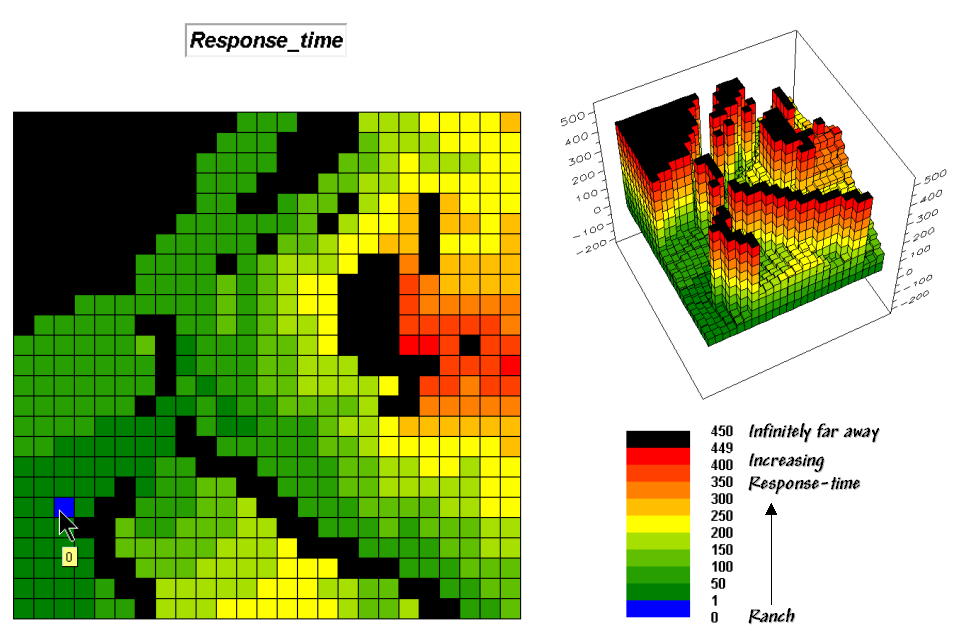 Response-time map.
Using the Response-time map. How far away is the farthest location that can be reached by emergency vehicles?
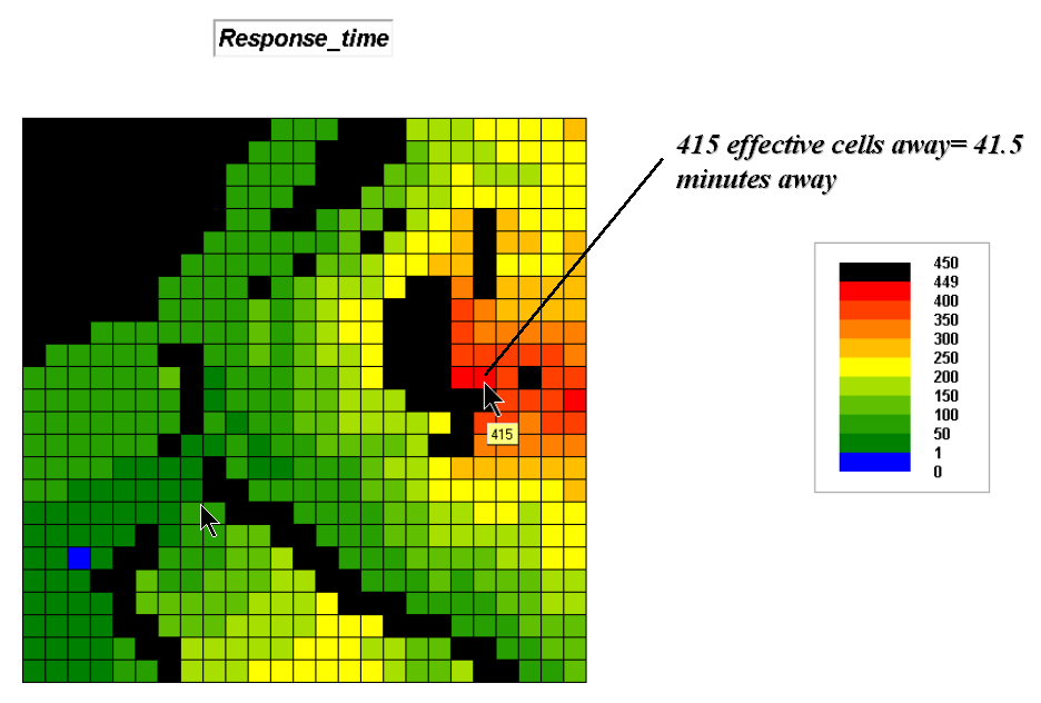 Farthest location is 41.5 minutes
away. Moving the cursor over any
map location displays the travel-time from the Ranch to that location.
Farthest location is 41.5 minutes
away. Moving the cursor over any
map location displays the travel-time from the Ranch to that location.
What is the
best route to the farthest location?
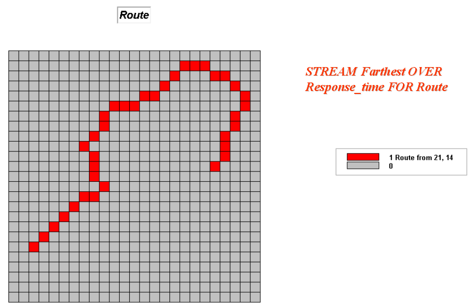 Optimal route (quickest) to the
farthest location. The
optimal route to any location is delineated by entering… STREAM
<Point> OVER
Optimal route (quickest) to the
farthest location. The
optimal route to any location is delineated by entering… STREAM
<Point> OVER
What is the
estimated elapsed time at each step along the best route?
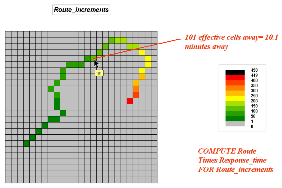 Travel-time along the optimal
route. A map of the travel-time
for each location along the optimal route is identified by… COMPUTE Route
Times Response_time FOR Route_increments
Travel-time along the optimal
route. A map of the travel-time
for each location along the optimal route is identified by… COMPUTE Route
Times Response_time FOR Route_increments
What portion
of the map area is within an 18-minute response time?
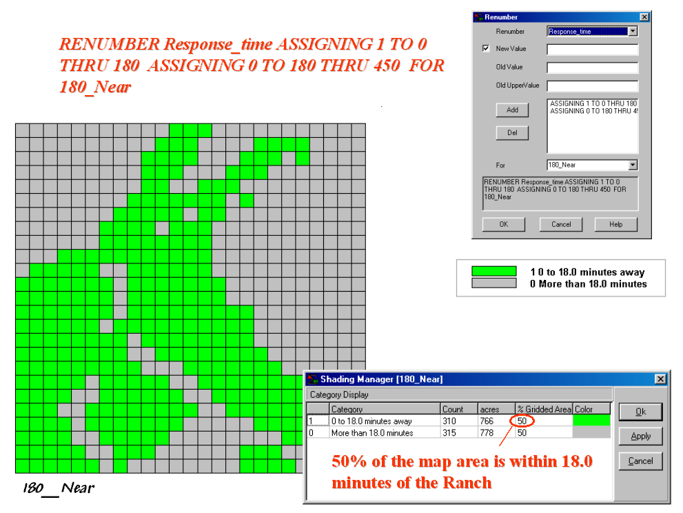 50% of the area is within an 18-minute
response time. A map identifying
the 0 to 18 minute response zone is obtained by entering… RENUMBER
Response_time ASSIGNING 1 TO 0 THRU 180
ASSIGNING 0 TO 180 THRU 450 FOR
180_Near
50% of the area is within an 18-minute
response time. A map identifying
the 0 to 18 minute response zone is obtained by entering… RENUMBER
Response_time ASSIGNING 1 TO 0 THRU 180
ASSIGNING 0 TO 180 THRU 450 FOR
180_Near
Can you display the response map in decimal-minutes instead of the “times ten” units?
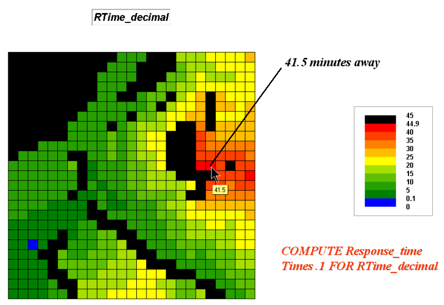 Response-time in decimal minutes. Simply
multiplying the Response_time map times .1 will convert the map values to
decimal-minutes… COMPUTE Response_time Times .1 FOR RTime_decimal
Response-time in decimal minutes. Simply
multiplying the Response_time map times .1 will convert the map values to
decimal-minutes… COMPUTE Response_time Times .1 FOR RTime_decimal
Summary. The initial Wildfire Response-time Model uses information about the various types of roads, terrain and land cover condition to simulate emergency vehicle response. The approach considers absolute barriers (surface water and very steep terrain) and relative barriers (road, steepness and cover condition) that “guide” movement. The result is a Response_time map that shows an estimated time to get equipment to each map location. Further analysis identifies the optimal route (quickest) to any location. The model can be extended to include different types of equipment, differences in season weather, and time estimates for a crew hiking into areas that are impassable for vehicles.
Note: see “Extending Wildfire Response Mapping”
for a discussion of techniques used to assign travel-time values for crews
hiking into areas that are too steep for vehicles and absolute barrier areas
along streams.