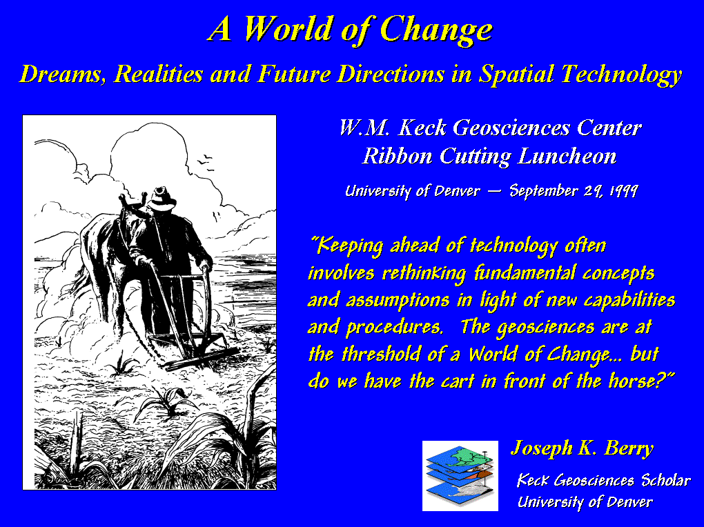
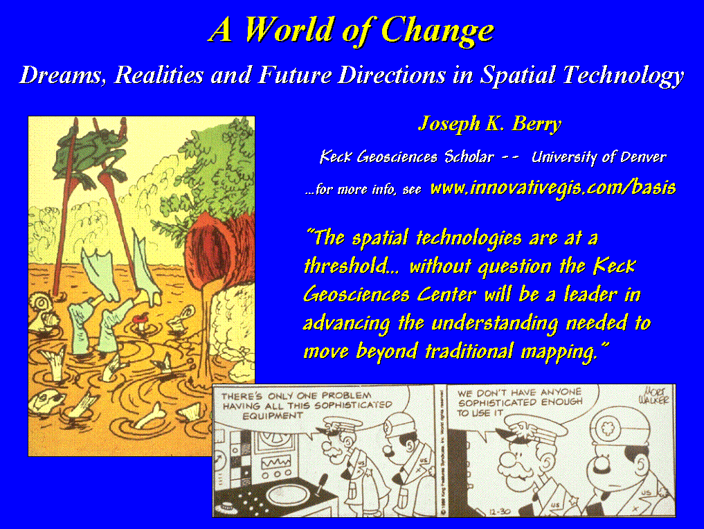
A World of
Change
Dreams, Realities and Future
Directions in Spatial Technology
by Joseph K. Berry, Keck Geosciences Scholar
W.M. Keck
Geosciences Center, Ribbon Cutting Luncheon
University of Denver — September 29, 1999
 [Slide #1 …title] In contemplating what to include in this talk, the idea of “where is GIS?” kept cropping up. Not so many years ago the answer to that
question was simply, “down the hall and
to the right, …I think?” In three
short decades, Geographic Information Systems have evolved from computer
mapping, to spatial database management systems, and more recently, to modeling
complex spatial relationships. However,
with the popularity of this technology, the readings of its current trends and
probable futures are as diverse as its growing community of users.
[Slide #1 …title] In contemplating what to include in this talk, the idea of “where is GIS?” kept cropping up. Not so many years ago the answer to that
question was simply, “down the hall and
to the right, …I think?” In three
short decades, Geographic Information Systems have evolved from computer
mapping, to spatial database management systems, and more recently, to modeling
complex spatial relationships. However,
with the popularity of this technology, the readings of its current trends and
probable futures are as diverse as its growing community of users.
Keeping ahead of technology often involves
rethinking fundamental concepts and assumptions in light of new capabilities
and procedures. The geosciences are at
the threshold of a "World of Change" induced by technology, but do we
have the cart in front of the horse?
What geographic concepts hold?
Which evolve under new map forms and expressions? What entirely new mechanisms and techniques
might arise? How do digital maps change
what we do and how we do it? Who are
the ultimate developers and users of this new technology?
These are interesting and
ponderous questions. Contrary to my
academic background, I will heed the King’s advice in Alice in
Wonderland—“…Begin at the beginning, and go until you come to the end; then
stop”—hopefully before dessert is a distant memory and your patience
exhausted.
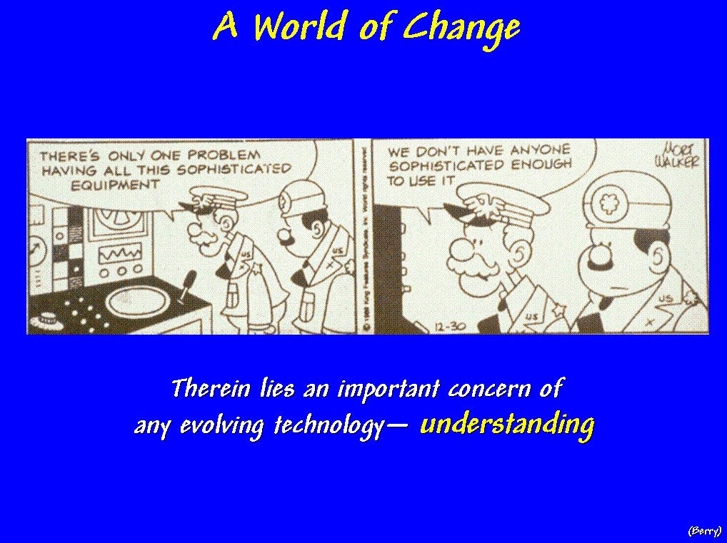 [Slide #2 …General
Halftrack] "…there’s only one problem having all this
sophisticated equipment; we don’t have anyone sophisticated enough to use it.”
[Slide #2 …General
Halftrack] "…there’s only one problem having all this
sophisticated equipment; we don’t have anyone sophisticated enough to use it.”
Therein
lies an important concern of any evolving technology—understanding. Not only is understanding needed at the
leading edge, but it's needed at the bleeding edge of general users. Education, both formal and informal is
needed to translate technological promise into practical reality.
SO, WHERE IS GIS EDUCATION?
GIS means different things
to different people. To some, it’s a
tool that extends mapping to the masses.
It allows the construction of custom maps from any desktop. It enables the spatially challenged to
electronically locate themselves on a map, request the optimal path to their
next destination, as well as checking the prices of motels along the way. When coupled with a cell phone, they can
call for help and their rescuers will triangulate on the signal, and deliver a
gallon of gas and an extra large pizza before its cold. Finding yourself has never been easier—the revolution of the digital map is firmly
in place.
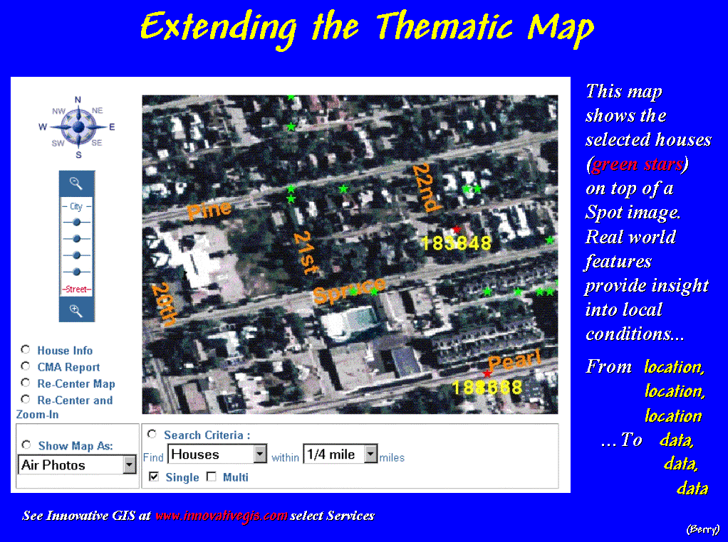
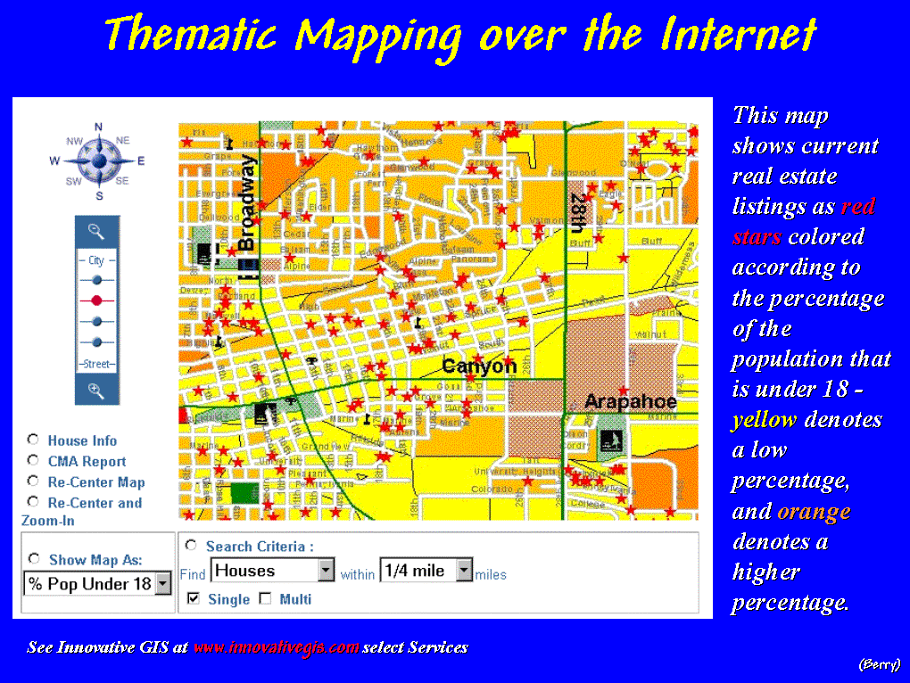 [Slide
#3…RealEstate1] For example, a new-age real
estate agent can search the local multiple listing for suitable houses, then
electronically “post” them to a map of the city.
[Slide
#3…RealEstate1] For example, a new-age real
estate agent can search the local multiple listing for suitable houses, then
electronically “post” them to a map of the city.
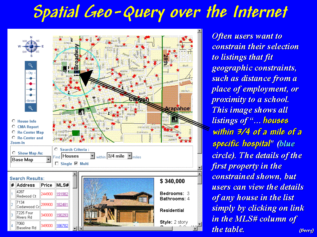 [Slide
#4 …RealEstate2] A few more mouse-clicks and a prospective buyer a thousand miles
away can take a video tour of the homes "within three-quarters of a
mile from the hospital where he will work." And by viewing a GPS-linked video, take a drive around the
neighborhood.
[Slide
#4 …RealEstate2] A few more mouse-clicks and a prospective buyer a thousand miles
away can take a video tour of the homes "within three-quarters of a
mile from the hospital where he will work." And by viewing a GPS-linked video, take a drive around the
neighborhood.
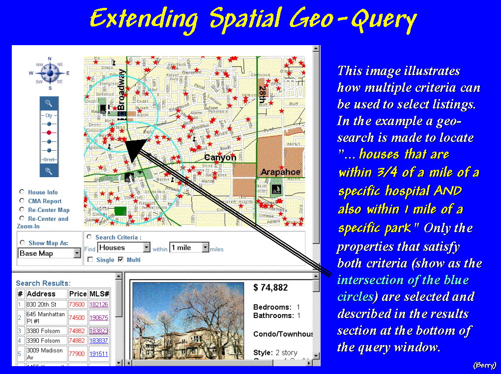 [Slide
#5 …RealEstate3] A quick geo-query of the spatially-linked database, locates
neighboring shopping centers, churches, schools and parks.
[Slide
#5 …RealEstate3] A quick geo-query of the spatially-linked database, locates
neighboring shopping centers, churches, schools and parks.
 [Slide
#6 …RealEstate4] The city’s zoning map, land use plan, proposed developments and aerial
imagery can be superimposed for a glimpse of future impacts. Demographic summaries by census tracts can
be generated and financial information for “comparables” can be plotted and
cross-linked for a better understanding of market dynamics. Armed with this information narrowing the
housing choices, a prospective buyer can “hit the ground running” right off the
plane—the revolution of spatial database
management is here, and increasingly, everywhere.
[Slide
#6 …RealEstate4] The city’s zoning map, land use plan, proposed developments and aerial
imagery can be superimposed for a glimpse of future impacts. Demographic summaries by census tracts can
be generated and financial information for “comparables” can be plotted and
cross-linked for a better understanding of market dynamics. Armed with this information narrowing the
housing choices, a prospective buyer can “hit the ground running” right off the
plane—the revolution of spatial database
management is here, and increasingly, everywhere.
CHALLENGING ACADEMIC
ORGANIZATION
(…or is that an oxymoron?)
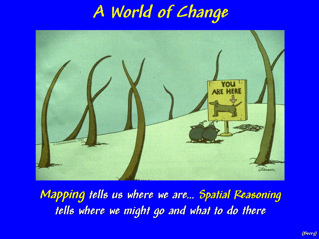 [Slide
#7 …Location
slide) Mapping
tells us where we are; spatial reasoning tells where we might go and what to do
there.
[Slide
#7 …Location
slide) Mapping
tells us where we are; spatial reasoning tells where we might go and what to do
there.
The “intellectual glue”
supporting new-age mapping and management applications of GIS is still being
forged on many campuses. The Keck
Geosciences Center is an intellectual and technical pillar in the whirlwind of
change altering how we view and interact with spatial phenomena. The facilities and faculty unquestionably
catapults the University of Denver to the forefront. However, along with these resources comes a great deal of
responsibility, and leadership in academic organization is near the top of the
list.
On less fortunate campuses,
GIS has spawned a quagmire of skirmishes, not new facilities and eager
individuals. Some view GIS as a money
pit draining the life-blood from traditional programs. It appears as an insatiable beast—like the
plant’s constant cry of “MORE!” in the play The Little Shop of Horrors, devouring
whole computer labs with a terabyte appetite and top-end taste in
peripherals. To others it's an
insertion of yet another "techno-science" into the already burgeoning
curricula and limited budgets. GIS’s
tentacles are tugging at every academic department, and on most campuses,
spatial technology is alternately viewed as Satan and savior like a Rorschach
inkblot.
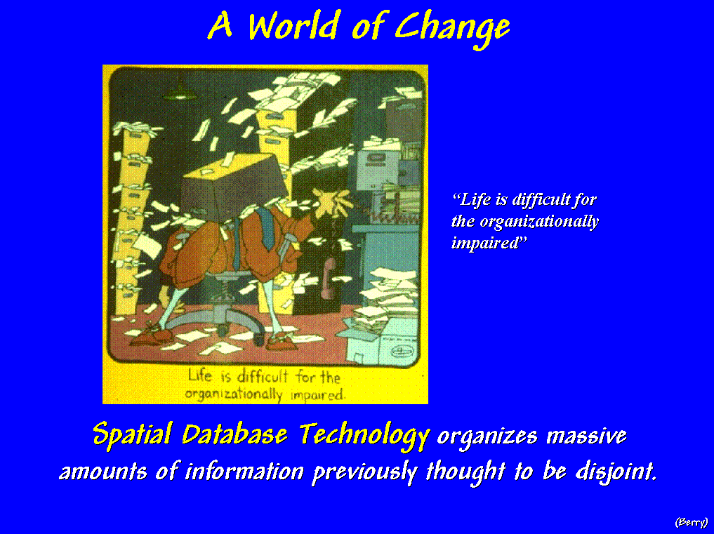 [Slide
#8 …Impaired
slide] "…Life
is difficult for the organizationally impaired"; spatial database
technology organizes massive amounts of information previously thought to be
disjoint.
[Slide
#8 …Impaired
slide] "…Life
is difficult for the organizationally impaired"; spatial database
technology organizes massive amounts of information previously thought to be
disjoint.
While a “center of excellence,” has obvious merits,
its place in the academic community must be nurtured. As with other aspects of campus life, GIS technology benefits
more from its diversity than from its oneness.
It's the challenge of the Keck Center to ensure that the multitude of
perspectives and paradigms of spatial technology across campus have a fertile
seedbed within its walls.
A chemist's view of space,
be it a microscope slide, in final analysis is not that different from a
geographer's. An anthropologist might
analyze a series of map layers for likely areas of former civilizations without
knowing that the GIS model she employed was nearly identical to that used by a
market forecaster in identifying areas of high propensity for home equity
loans.
Space has become the common denominator
for a myriad of applications and geography is the common language. The speed that GIS becomes intertwined into
the fabric of society, and spatial reasoning a matter of fact, will be
influenced by a "Center that's not centralized."
The GIS Whole Is Greater Than the Sum of Its
Parts
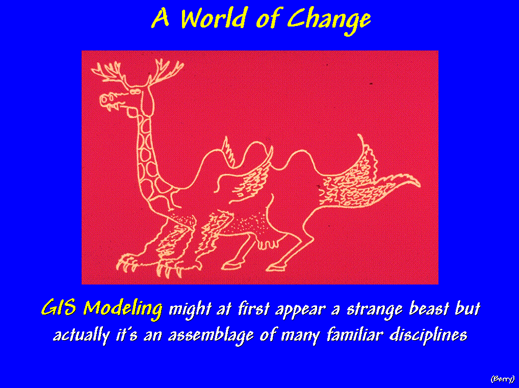 [Slide
#9 …Strange
Beast] GIS
modeling might at first appear a strange beast but actually it’s an assemblage
of many familiar disciplines and common sense.
[Slide
#9 …Strange
Beast] GIS
modeling might at first appear a strange beast but actually it’s an assemblage
of many familiar disciplines and common sense.
The issues of "What
GIS is (and isn’t)" and "Who is a GIS'er" are
critical in the evolution—no revolution— occurring in the geosciences. Some of the earlier responses defined it as
a mapping science, and it became the domain of the cartography unit on
campus. Other responses emphasized its
computer and database underpinnings and placed it in the computer science
department.
Most current definitions,
however, spring from a multitude of applications in diverse departments, such
as natural resources, land planning, engineering, business and the health
sciences. The result is a patchwork of GIS
definitions aligning with the separate discipline perceptions of its varied
applications.
WHAT IS GIS EDUCATION?
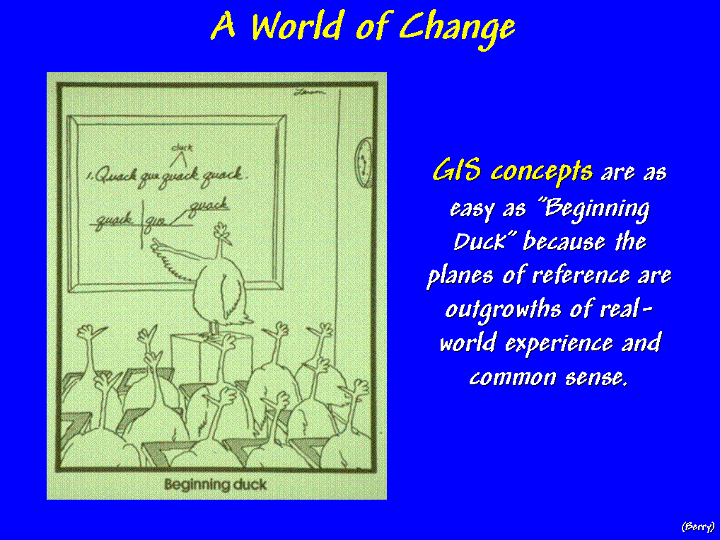 [Slide
#10 …Beginning Duck
slide] …actually,
GIS concepts are as easy as "Beginning Duck" because the planes of
reference are outgrowths of real-world experience and common sense.
[Slide
#10 …Beginning Duck
slide] …actually,
GIS concepts are as easy as "Beginning Duck" because the planes of
reference are outgrowths of real-world experience and common sense.
Our struggles in defining
GIS revolve less around its mapping and management concerns, than its
application contexts and expressions.
Although there are variations in data structures, a myriad of
geo-referencing possibilities, and a host of methods to derive map displays,
it’s GIS’s modeling component that causes most of the confusion and heated
debates of "what GIS is (and isn’t)."
We have been mapping and
managing spatial data for a long time.
The earliest systems involved file cabinets of information that were
linked to maps on the wall through "shoe leather." One would simply wear a path between the map
and files whenever spatial and descriptive data were needed.
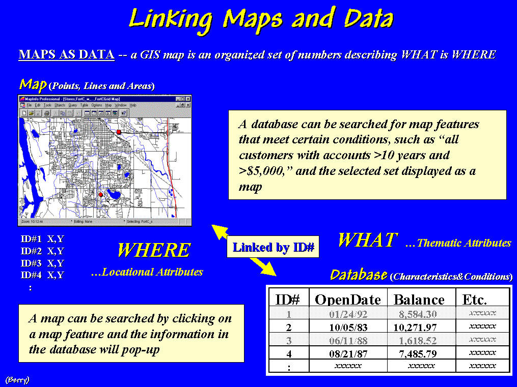 [Slide
#11 …Linking Maps
and Data] The
electronic link between mapping and data management certainly has expedited this process and
saved considerable shoe leather… but come to think of it, it hasn’t
fundamentally changed the process. GIS
software’s mapping and data management components are a result of a
technological evolution, whereas its modeling component is a revolution
in our perception of geographic space, spatial relationships and users of
maps.
[Slide
#11 …Linking Maps
and Data] The
electronic link between mapping and data management certainly has expedited this process and
saved considerable shoe leather… but come to think of it, it hasn’t
fundamentally changed the process. GIS
software’s mapping and data management components are a result of a
technological evolution, whereas its modeling component is a revolution
in our perception of geographic space, spatial relationships and users of
maps.
GIS Modeling AND SPATIAL REASONING
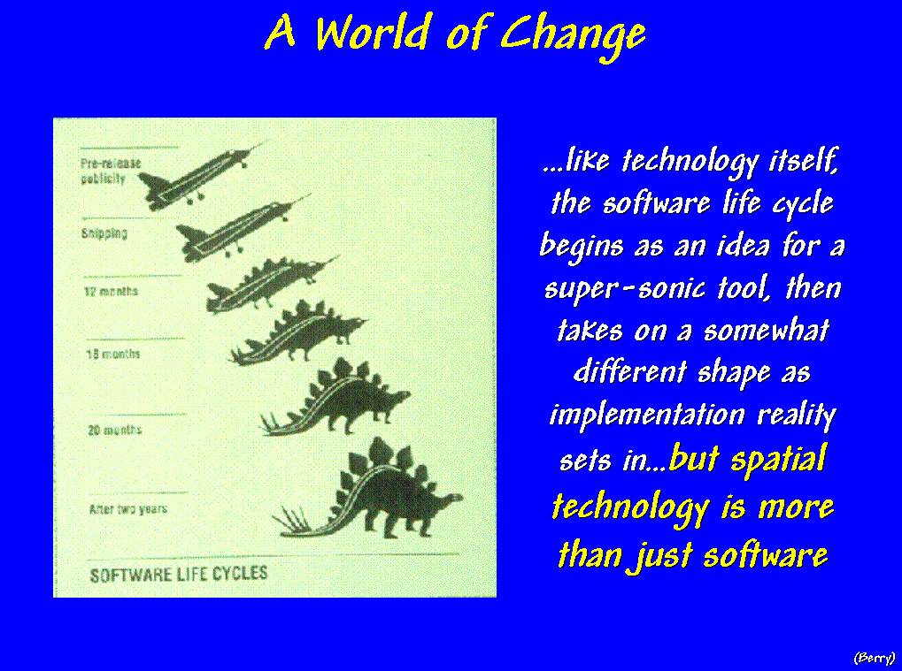 [Slide
#12 …Software Life
Cycles] …like
technology itself, the software life cycle begins as an idea for a super-sonic
tool, then takes on a somewhat different shape as implementation reality sets
in…but keep in mind, spatial technology is more than just software.
[Slide
#12 …Software Life
Cycles] …like
technology itself, the software life cycle begins as an idea for a super-sonic
tool, then takes on a somewhat different shape as implementation reality sets
in…but keep in mind, spatial technology is more than just software.
 [Slide
#13 …Investigating
Spatial Relationships] In today's world, maps are
numbers first, pictures later. This new
perspective of spatial data is destined to change our paradigm of map analysis,
as much as it changes our procedures.
[Slide
#13 …Investigating
Spatial Relationships] In today's world, maps are
numbers first, pictures later. This new
perspective of spatial data is destined to change our paradigm of map analysis,
as much as it changes our procedures.
For example, consider the
emerging field of Precision Farming. With mud up to axles and 400
acres left to plow, precision in farming can seem worlds away. Yet site-specific
management makes sense to a rapidly growing number of farmers. Mapping and analyzing field variability for
better economic and ecological decisions puts production agriculture at the
cutting edge of GIS applications—both down to earth and downright
ambitious.
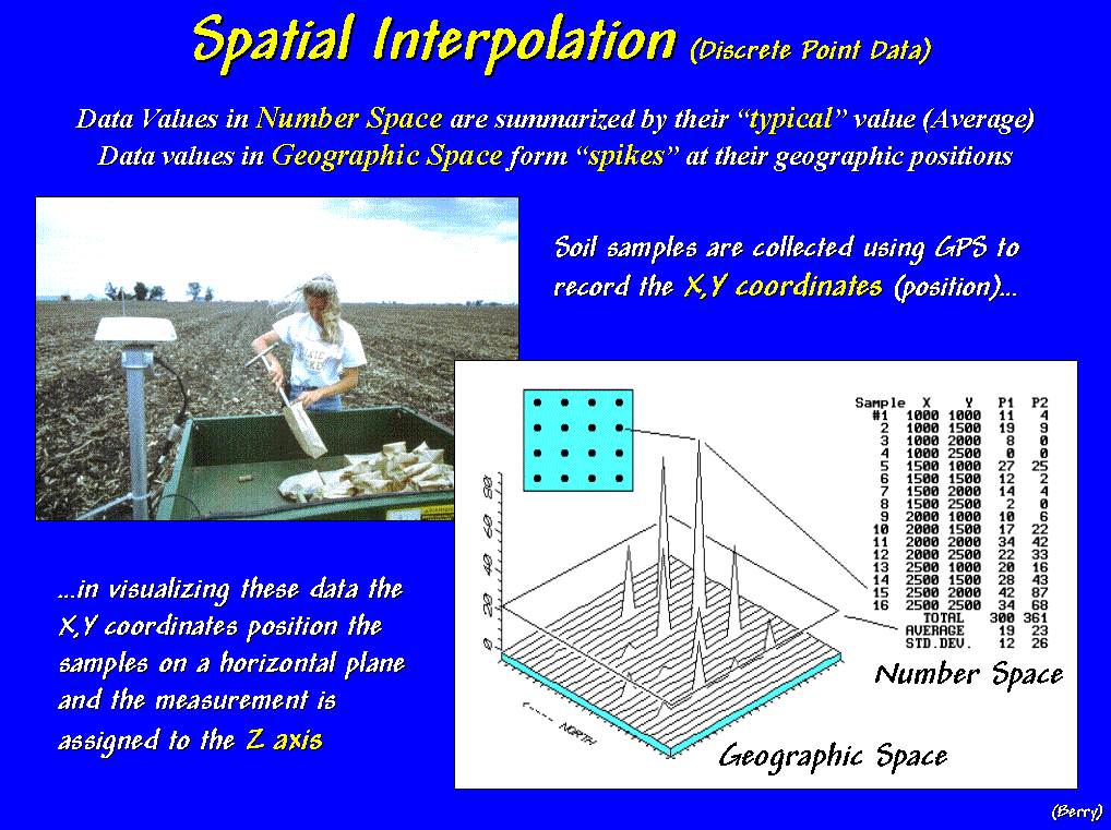 [Slide
#14 …Sstat1_Descrete] Traditionally, fertilization programs were
determined by averaging soil samples taken throughout a field. Today, soil samples are collected with GPS
coordinates then spatially interpolated for maps of nutrient variations
throughout a field. This process can be
conceptualized…
[Slide
#14 …Sstat1_Descrete] Traditionally, fertilization programs were
determined by averaging soil samples taken throughout a field. Today, soil samples are collected with GPS
coordinates then spatially interpolated for maps of nutrient variations
throughout a field. This process can be
conceptualized…
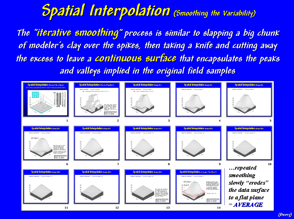 [Slide
#15 …Sstat2_Animation] …as first "guessing"
that all of the non-sampled locations are identical to the closest sample point
(click on the hyperlink to the SStat slide set). The next series of steps involves passing a
"smoothing filter" over the data… once, twice, three, four
times. Now that looks like what the
point data was trying to tell you—more phosphorous in the NE portion of the
field, not much in the NW.
[Slide
#15 …Sstat2_Animation] …as first "guessing"
that all of the non-sampled locations are identical to the closest sample point
(click on the hyperlink to the SStat slide set). The next series of steps involves passing a
"smoothing filter" over the data… once, twice, three, four
times. Now that looks like what the
point data was trying to tell you—more phosphorous in the NE portion of the
field, not much in the NW.
The “smoothing” process is
similar to slapping a big chunk of modeler’s clay over the data spikes, then
taking a knife and cutting away the excess to leave a continuous surface that
encapsulates the peaks and valleys implied in the original field samples—a map
of the variation in phosphorous throughout the field.
But what if we keep
smoothing the data? … 9 times, 19, 29,
39, 49, 99 times! What do you think
would happen if you smoothed it 9,999 times?
(…last slide in the animated series) Yep, it would be a
horizontal plane aligning with the arithmetic average (…press Esc to
return, then advance to slide #16).
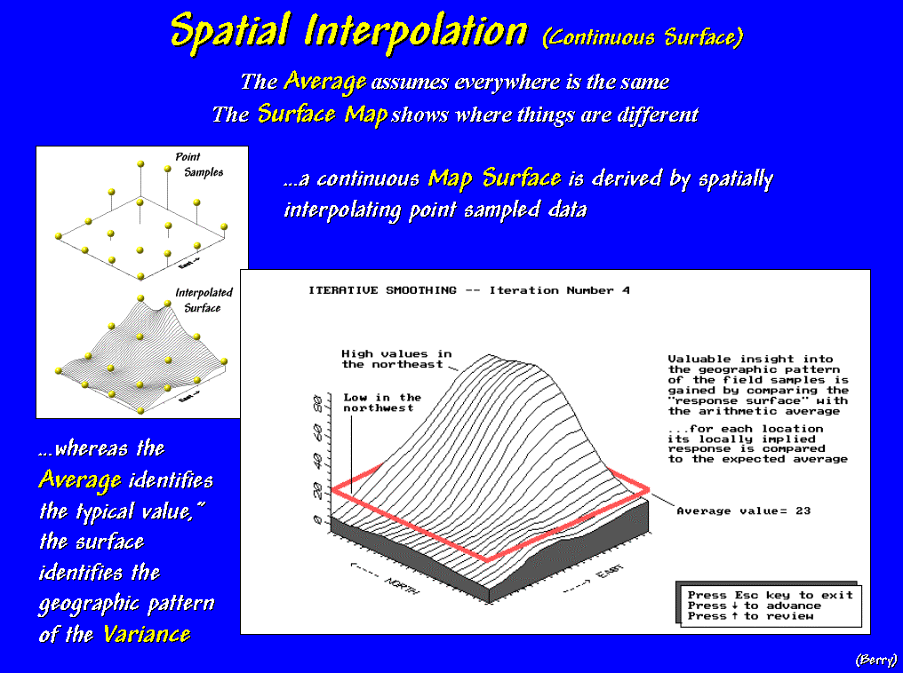 [Slide
#16 …Sstat3_Continuous] Note that the whole-field average is hardly
anywhere. Most of the field is either
well-above or well-below the average. A
fertilization application based on the assumption that the "average"
amount of phosphorous is everywhere, would be adding even more in the NE where
it's not needed and probably not enough in the NW where it' deficient—bad for
the environment and bad the pocketbook.
[Slide
#16 …Sstat3_Continuous] Note that the whole-field average is hardly
anywhere. Most of the field is either
well-above or well-below the average. A
fertilization application based on the assumption that the "average"
amount of phosphorous is everywhere, would be adding even more in the NE where
it's not needed and probably not enough in the NW where it' deficient—bad for
the environment and bad the pocketbook.
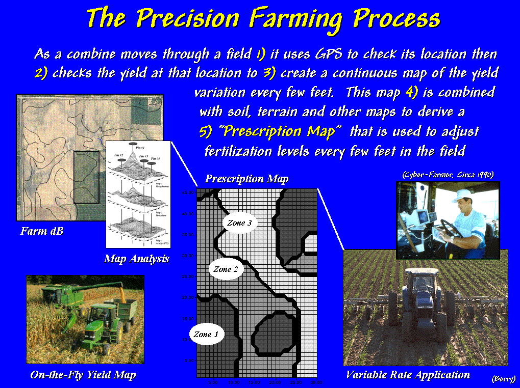 [Slide
#17 …PF Process] The Precision Farming process "is about doing the right
thing, in the right way, at the right place and time."
[Slide
#17 …PF Process] The Precision Farming process "is about doing the right
thing, in the right way, at the right place and time."
As a combine moves through a
field it checks the GPS location and yield flow every second and writes this
information to a data file that is used to generate a map of yield variation
every few feet throughout a field. This
map is combined with soil, terrain and other mapped data to derive a “Prescription
Map” that is used to automatically adjust fertilization levels every few
feet as a spray rig moves in the field.
The result is to constantly adjust the fertilization prescription to the
unique combination of conditions occurring in the field.
Whew!!!
…farmers at the cutting edge of GIS; what'll they think of next? Consider another "non-traditional"
perspective of geographic space—a floor plan of a superstore—and another
off-the-wall new user of spatial technology—a retail store manager.
 [Slide
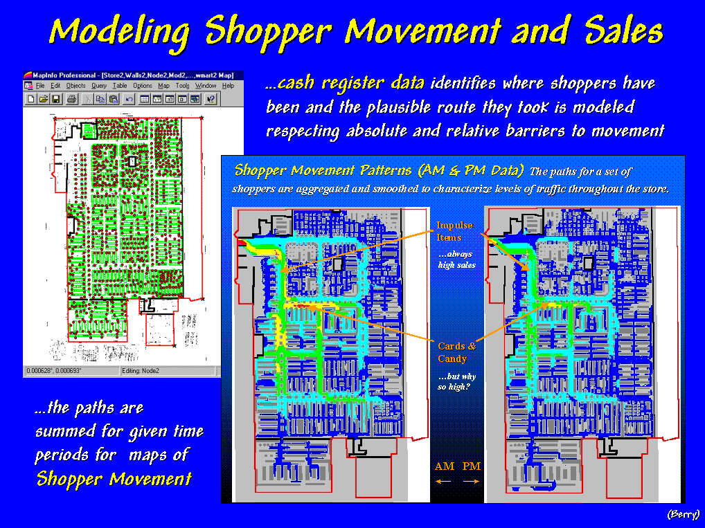
#18 …Shopper Movement] In a sense, the floor plan of a mega-store—the graphic on the
left—is similar to a street map of Manhattan.
The aisles are like streets and the shelves are like apartment houses. Use of the map involves navigating the
aisles to pickup items on the shelves then head for the checkout.
[Slide
#18 …Shopper Movement] In a sense, the floor plan of a mega-store—the graphic on the
left—is similar to a street map of Manhattan.
The aisles are like streets and the shelves are like apartment houses. Use of the map involves navigating the
aisles to pickup items on the shelves then head for the checkout.
The cash register data identifies where shoppers
have been and the plausible route they took can be modeled. The implied paths for each shopping cart
are summed over specified time periods to generate maps of shopper movement and
sales activity. The pair of maps on the
right identifies shopper movement for a morning and an afternoon period. Note the high activity depicted as warmer
tones around the "impulse items" at the checkouts during both
periods.
What is counter-intuitive is the very high activity
in the "cards and candy section."
At first this was thought to be a data or modeling error but the results
were persistent. The explanation didn't
come until the client revealed that the test data set was for a 24-hour period
before Valentine's Day.
When shopper movement is compared to maps of sales
activity the store manager can identify areas where shoppers are constantly
passing but not purchasing—his thoughts quickly move to changing the product
mix on the end-caps.
 [Slide
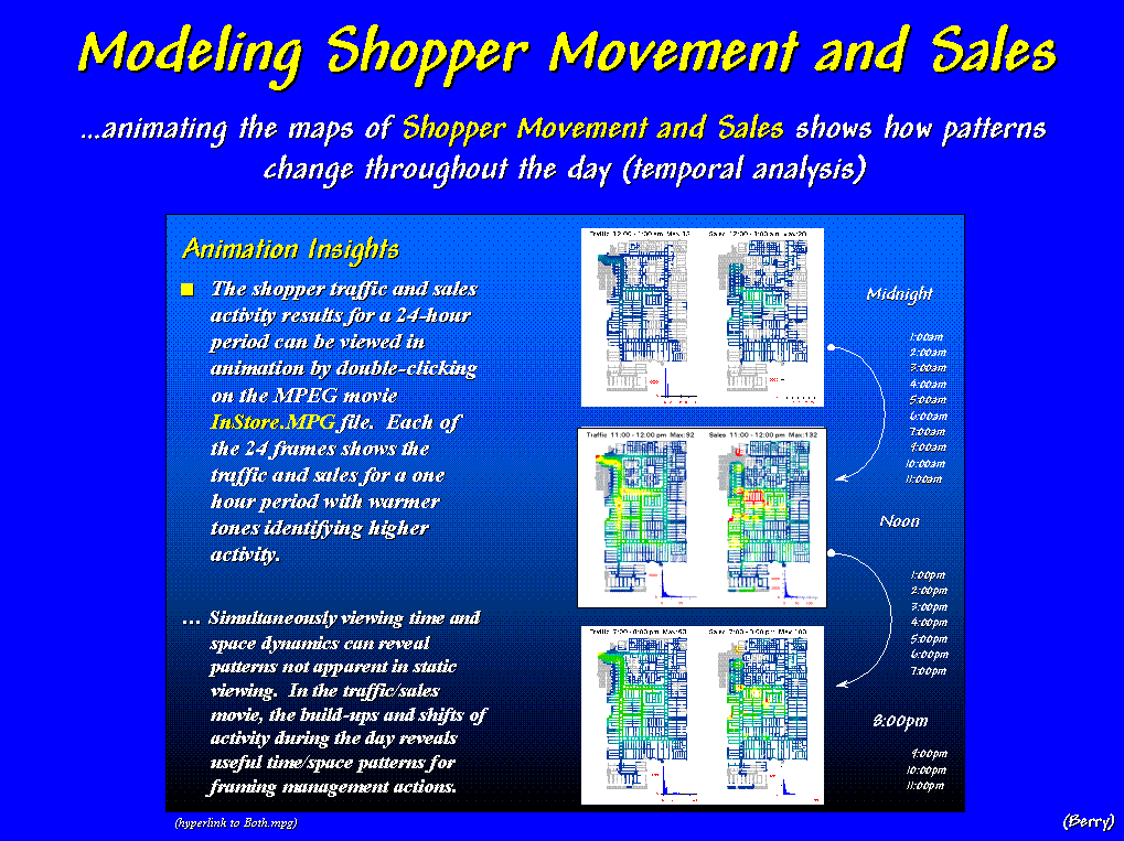
#19 …Shopper Movement--animation] The GIS model can be extended by "animation" of the
maps of Shopper Movement and Sales to show how patterns change throughout the
day (…click on the hyperlink to activate). When the side-by-side displays are animated,
the warmer colors of higher activity appear to roll in and out like wisps of
fog under the Golden Gate Bridge. The
similarities and miss-matches in the ebb and flow of movement and sales provide
a dramatic view of the spatial/temporal relationships contained in the
traditionally non-spatial records of cash registers receipts. (…stop the
mpeg movie, then advance to slide #20).
[Slide
#20 …Video Mapping
System]
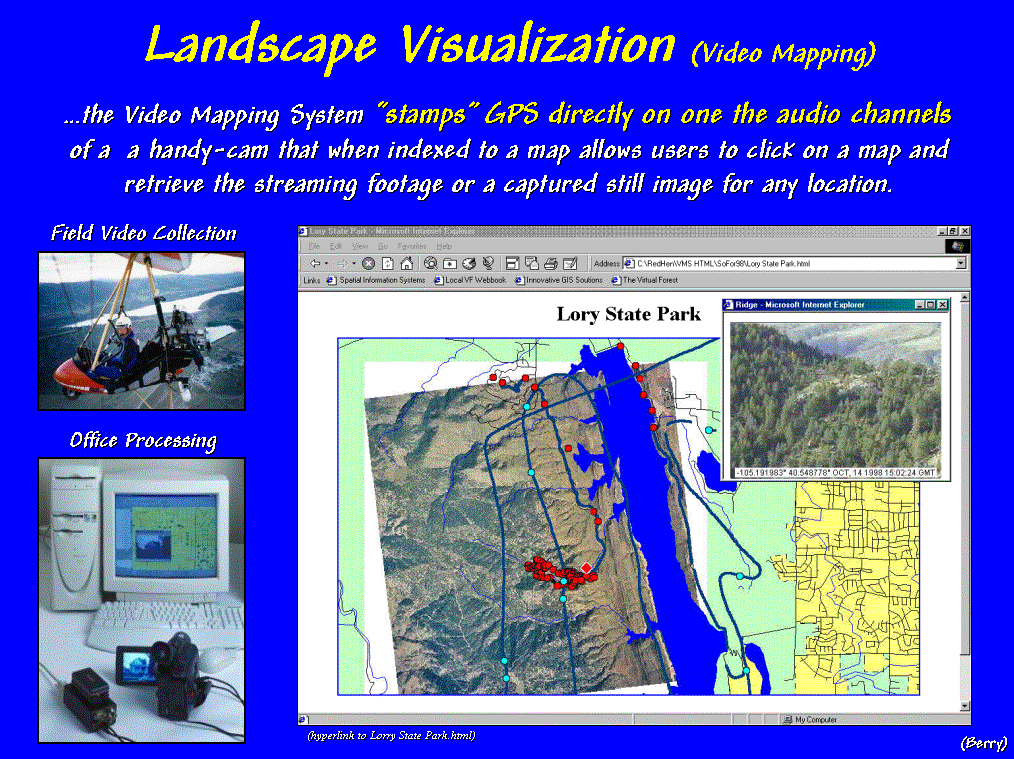
That brings us to another
"beyond mapping" application—the linking of multimedia and
GIS. GPS signals can be
"stamped" to one of the audio channels whenever a handy-cam is
used. When the tape is played back to
the computer, it's automatically geo-referenced to a base map. This allows users to click on a map and
retrieve the streaming footage or a captured still image for any location. (…hyperlink to HTMLs)
[#] For example, an
ultralite—you know a hang glider with
an engine—was used for a “bumblebee”
flight over Lorry State Park. Clicking
anywhere along the flight path brings up the aerial footage beginning at that
location. Users can “drop a pin” at any
point and capture a still image for that location (…click on a couple of
blue dots).
[#] Field plots can be
augmented with images, as well as traditional inventory data and summary
statistics (…click on a couple of red dots). In this vein, field data collection is
extended to field experience collection that tempers abstract maps
and dense tables with glimpses of reality (…return from hyperlink).
 [Slide #21 …VF general
scene] GIS's "paper map"
legacy is extended through a rich set of geo-query and display tools that
facilitate data handling. Video
multimedia links the GIS to reality.
However, effective decision-making requires more than just data access
and graphical presentation of current conditions.
[Slide #21 …VF general
scene] GIS's "paper map"
legacy is extended through a rich set of geo-query and display tools that
facilitate data handling. Video
multimedia links the GIS to reality.
However, effective decision-making requires more than just data access
and graphical presentation of current conditions.
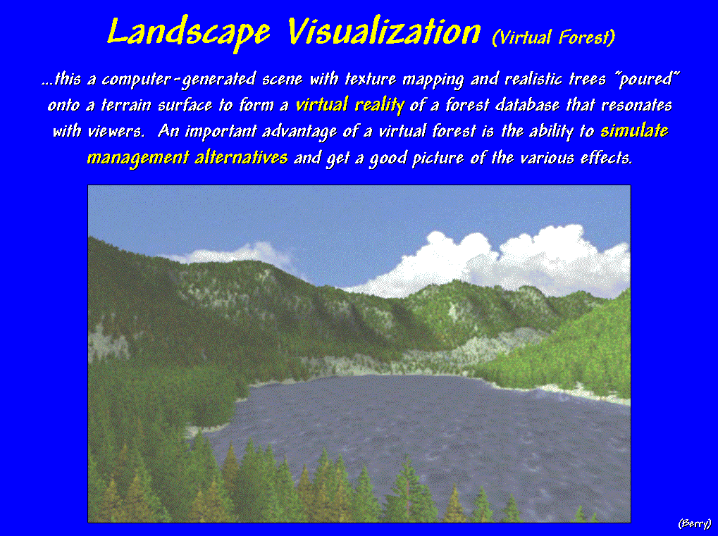
GIS not only describes “what is,” but can help us visualize and
communicate “what could be.” This slide is a computer-generated scene
with texture mapping and rendering replacing familiar map colors and symbols
with realistic tree-objects that are “poured” onto a terrain surface. The result is a virtual reality of a forest
database that resonates with viewers.
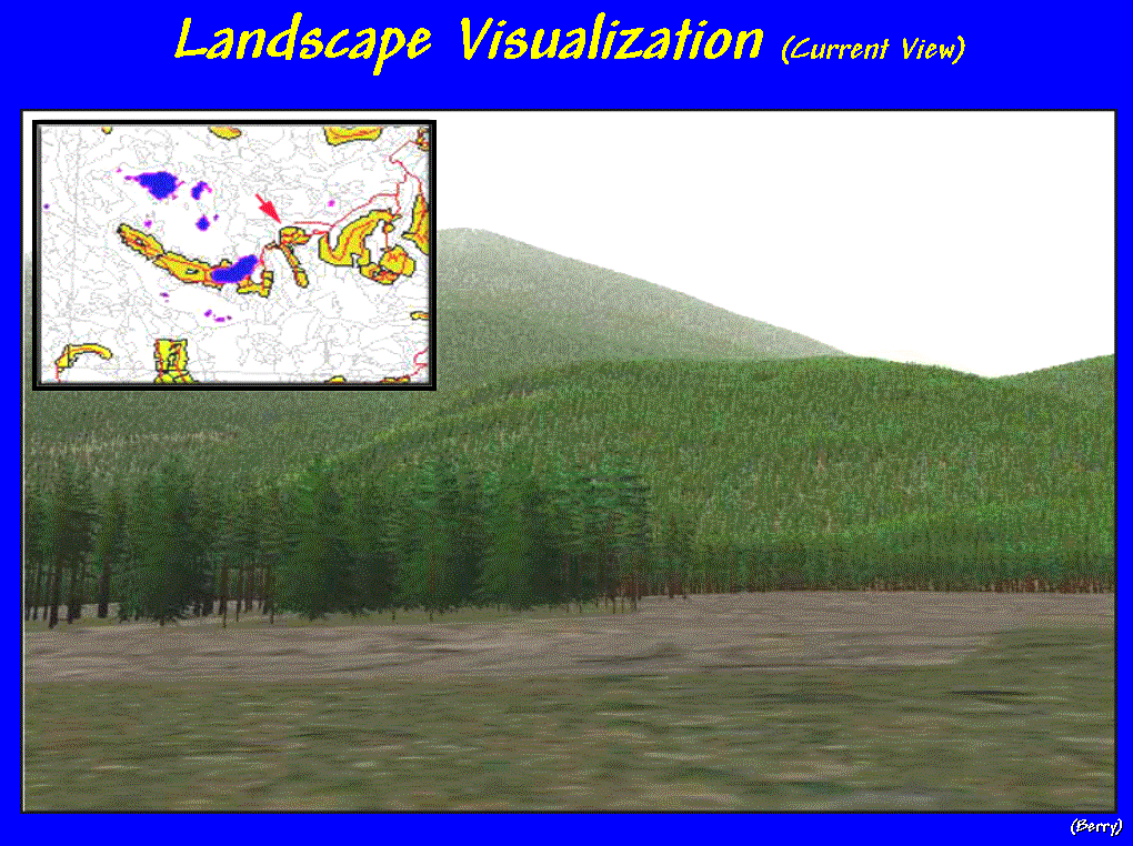 [Slide #22 …Forested scene] An important advantage of a virtual forest is the ability to
simulate management alternatives and get a good picture of various
effects. For example, consider this
computerized landscape derived from an ArcInfo vegetation map. Inventory data of tree type, age, composition
and stocking for each forest parcel is used to place the trees, grass, and
other features in the scene. But what
would the scene look like if a clear-cut were introduced?
[Slide #22 …Forested scene] An important advantage of a virtual forest is the ability to
simulate management alternatives and get a good picture of various
effects. For example, consider this
computerized landscape derived from an ArcInfo vegetation map. Inventory data of tree type, age, composition
and stocking for each forest parcel is used to place the trees, grass, and
other features in the scene. But what
would the scene look like if a clear-cut were introduced?
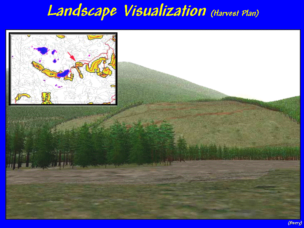 [Slide #23 …Clearcut scenario A] The
user should be able to query a simulation as easily as they geo-query a static
database. In this example, the user
simply identified the type of harvest and the forest parcels involved to
generate the simulated rendering. Or
different harvest boundaries can be simulated…
[Slide #23 …Clearcut scenario A] The
user should be able to query a simulation as easily as they geo-query a static
database. In this example, the user
simply identified the type of harvest and the forest parcels involved to
generate the simulated rendering. Or
different harvest boundaries can be simulated…
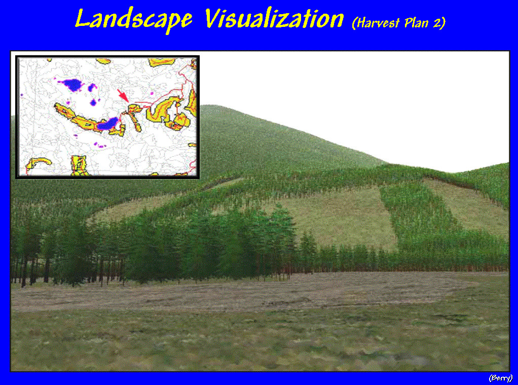 [Slide #24 …Clearcut scenario B] …to investigate the visual impacts of other
possible bad haircuts. To be effective
in decision-making, the interaction with a GIS must be immediate and
comfortable for the decision-makers. If
there is a time-lag for GIS wizards to concoct their magic, the interactive
dialog with mapped data is lost.
[Slide #24 …Clearcut scenario B] …to investigate the visual impacts of other
possible bad haircuts. To be effective
in decision-making, the interaction with a GIS must be immediate and
comfortable for the decision-makers. If
there is a time-lag for GIS wizards to concoct their magic, the interactive
dialog with mapped data is lost.
 Concluding Thoughts… A
PARADIGM SHIFT TO SPATIAL REASONING
Concluding Thoughts… A
PARADIGM SHIFT TO SPATIAL REASONING
[Slide #25 …Conclusion] Whew… by now all this might seem a bit deep and farfetched. However, it is certain that the future
trends in GIS are taking us farther from the traditional map room to unfamiliar
areas where spatial technology isn't a static map but an active ingredient in
spatial reasoning by a host of non-traditional map users. Within this context, GIS evolves from its
traditional roles of automated cartography, thematic mapping and geo-query to
an integral part of how we address complex spatial issues.
Along this path, many of the
changes in mapping will be found in new applications. Effective education and communication with the growing world of
map users becomes the catalyst for transformation. The students, staff and faculty at the Keck Geosciences Center
are armed with the resources and opportunities to lead spatial technology during
this dynamic period. As with most
things geographical, people and place are the key elements—in
this instance, they ensure the University of Denver a leadership role in the
geosciences' changing world.
Joseph
K. Berry, Keck Geosciences Scholar
University
of Denver, September 29, 1999
___________________________
Speaker's note: More information on topics discussed in this presentation is
posted online at…
ü
http://www.innovativegis.com/basis/present/present.html
select Online Papers, "Education, Vocation and GIS Enlightenment"
ü
http://www.innovativegis.com/basis/present/present.html
select PowerPoint Presentations, "Conceptual Understanding of
Interpolation Surfaces"
ü
http://www.innovativegis.com/basis/pfprimer/
select "The Precision Farming Primer—Introduction"
ü
http://www.innovativegis.com/basis/present/present.html
select Online Papers, "Spatial Analysis of Shopper Movement and
Sales Activity"
ü
http://www.redhensystems.com/
select "Video Mapping System"
ü
http://www.innovativegis.com/
select "Virtual Forest"