|
Beyond
Mapping IV Introduction
– Extending
Basic GIS Concepts (Further Reading) |
GIS Modeling book |
Is it
Soup Yet? — describes the evolution in GIS definitions and
terminology (February 2009)
What’s
in a Name — suggests and defines the new more
comprehensive term “Geotechnology” (March 2009)
<Click here> for a printer-friendly version of this topic (.pdf).
(Back
to the Table of Contents)
______________________________
Is
it Soup Yet?
(GeoWorld,
February 2009)
In the forty-odd years of computer-tinkering with maps our perspectives
and terminologies have radically changed.
My first encounter was in the late 1960s as an undergraduate research
assistant at the University of California, Berkeley. The entry point was through photogrammetric
interpretation in the pursuit of a high resolution contour map for the school’s
forest. In those days one stared at pair
of stereo-matched aerial photos and marched a dot at a constant elevation
around the three-dimensional surface that appeared. The result was an inked contour line drawn by
a drafting arm that was mechanically connected to the stereo plotter— raise the
dot and re-walk to delineate the next higher contour line.
The research effort took this process to a new level by augmenting the
mechanical arm with potentiometers that converted the movements of the arm into
X,Y coordinates that, in turn, were recorded by direct
entry into a keypunch machine.
After several months of tinkering with the Rube Goldberg device several
boxes of punch cards were generated containing the digital representation of
the contour lines that depicted the undulating shape of the terrain
surface.
The card boxes then were transferred to a guru who ran the only
large-bed plotter on campus and after a couple of more months of tinkering the
inked lines emerged. While far from
operational, the research crossed a technological threshold by replacing the
analog mechanics of traditional drafting with the digital encoding required to
drive the cold steel arm of a plotter—maps were catapulted from drawings to
organized sets of numbers.
In the 1970’s Computer Mapping emerged through the efforts of
several loosely allied fields involved in mapping—geography for the underlying
theory, computer science for the software, engineering for the hardware and
several applied fields for the practical applications.
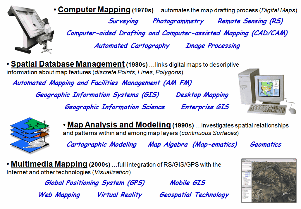
Figure 1. The terminology
and paradigm trajectory of GIS’s evolution.
As depicted in figure 1, some of the more important perspectives and
definitions of the emerging technology at that time were:
-
Surveying is the technique and science of accurately
determining the terrestrial or three-dimensional space position of points and
the distances and angles between them where these points are usually, but not
exclusively, associated with positions on the surface of the Earth, and are
often used to establish land maps and boundaries for ownership or governmental
purposes. (Wikipedia definition)
-
Photogrammetry is the first remote sensing technology ever
developed, in which geometric properties about objects are determined from
photographic images. (Wikipedia
definition)
-
Remote Sensing is the small or
large-scale acquisition of information of an object or phenomenon, by the use
of either recording or real-time sensing device(s) that is not in physical or
intimate contact with the object (such as by way of aircraft, spacecraft,
satellite, etc.). (Wikipedia
definition)
-
Computer-aided Drafting and Computer-assisted Mapping (CAD/CAM) is the
mapping expression of Computer-aided Design that uses computer technology to aid in the design and particularly the
drafting (technical drawing and engineering drawing) of a part or product. (Wikipedia definition)
-
Automated Cartography is the process of
producing maps with the aid of computer driven devices such as plotters and
graphical displays. (Webopedia definition)
-
Image processing is any form of signal processing for which
the input is an image, such as photographs or frames of video with the output
of image processing being either an image or a set of characteristics or parameters related to the image. (Wikipedia definition)
The common thread at the time was an inspiration to automate the map
drafting process by exploiting the new digital map form. The focus was on the graphical rendering of
the precise placement of map features—an automated means of generating
traditional map products. For example,
the boxes of cards containing the contour lines of research project were
mothballed after the plotter generated the printer’s separate used for printing
multiple copies of the map.
Spatial
Database Management expanded this view in the 1980s by combining the digital map
coordinates (Where) with database attributes describing the map features
(What).
The focus shifted to the digital nature of mapped data and the new
organizational capabilities it provided.
Some of the perspectives and terms associated with the era were:
-
Automated Mapping and Facilities Management (AM-FM) seeks
to automate the mapping process and to manage facilities represented by items
on the map. (GITA definition)
-
Geographic Information System
(GIS) is an information system for capturing,
storing, analyzing, managing and presenting data which are spatially referenced
(linked to location). (Wikipedia
definition)
-
Geographic Information Science (GISc or GISci) is the academic theory behind the development,
use, and application of geographic information systems (GIS). (Wikipedia definition)
-
Desktop Mapping involves using a desktop computer to perform
digital mapping functions. (eNCYCLOPEDIA definition)
-
Enterprise GIS is a platform for delivering organization-wide
geospatial capabilities providing for the free flow of information. (ESRI definition)
Geo-query became the rage and organizations
scurried to integrate their paper maps and management records for cost savings
and improved information access. The
overriding focus was on efficient recordkeeping, processing and information
retrieval. The approach linked discrete
Point, Line and Polygon features to database records describing the spatial
entities.
Map Analysis
and Modeling in the 1990s changed the traditional mapping paradigm by introducing a
new fundamental map feature—the continuous Surface. Some of the more important terms and
perspectives of that era were:
-
Cartographic Modeling is a process that
identifies a set of interacting, ordered map operations that act on raw data,
as well as derived and intermediate data, to simulate a spatial decision making
process. (Tomlin definition)
-
Map Algebra (and Map-ematics) is a simple and an elegant set-based algebra
for manipulating geographic data where the input and output for each operator
is a map and the operators can be combined into a procedure to perform complex
tasks. (Wikipedia definition)
-
Geomatics incorporates the older field of surveying
along with many other aspects of spatial data management which integrates
acquisition, modeling, analysis, and management of spatially referenced
data. (Wikipedia definition)
While much of the map-ematical
theory and procedures were in place much earlier, this era saw a broadening of
interest in map analysis and modeling capabilities. The comfortable concepts and successful
extensions of traditional mapping through Spatial Database Management systems
lead many organizations to venture into the more unfamiliar realms of spatial
analysis and statistics. The emerging
applications directly infused spatial considerations into the decision-making
process by expanding “Where is What?”
recordkeeping to “Why, So What and What If?” spatial reasoning—thinking
with maps to solve complex problems.
Multimedia Mapping in
the 2000s turned the technology totally on its head by bringing it to the
masses. Spurred by the proliferation of
personal computers and Internet access, spatial information and some “killer
apps” have redefined what maps are, how one interacts with them, as well as
their applications. Important terms and
perspectives of the times include:
-
Global Positioning System
(GPS) is the only fully functional Global
Navigation Satellite System (GNSS) that enable GPS receivers to determine their
current location, the time, and their velocity.
(Wikipedia definition)
-
Mobile GIS is the use
of geographic data in the field on mobile devices that integrates three
essential components— Global Positioning System (GPS), rugged handheld
computers, and GIS software. (Trimble
definition)
-
Web Mapping is the process of designing, implementing,
generating and delivering maps on the World Wide Web. (Wikipedia definition)
-
Virtual Reality (VR) is a technology which allows a
user to interact with a computer-simulated environment, be it a real or
imagined one. (Wikipedia definition)
-
Geospatial Technology refers to technology used for visualization,
measurement, and analysis of features or phenomena that occur on the earth that
includes three different technologies that are all related to mapping features
on the surface of the earth— GPS (global positioning systems), GIS
(geographical information systems), and RS (remote sensing). (Wikipedia definition)
The technology has assumed a commonplace
status in society as people access real-time driving directions, routinely check
home values in their neighborhood and virtually “fly” to anyplace place on the
earth to view the surroundings or checkout a restaurant’s menu. While spatial information isn’t the driver of
this global electronic revolution, the technology both benefits from and
contributes to its richness. What was
just a gleam in a handful of researchers’ eyes thirty years ago has evolved
into a pervasive layer in the fabric of society, not to mention a major
industry.
But what are the perspectives and terms defining
the technology’s future? That’s ample
fodder for the next section.
_____________________________
Author’s Notes: a brief White Paper describing GIS’s evolution is posted online at www.innovativegis.com/basis/Papers/Other/Geotechnology/Geotechnology_history_future.htm
. An interesting and useful Glossary of
GIS terms by Blinn, Queen and Maki of the University
of Minnesota is posted at www.extension.umn.edu/distribution/naturalresources/components/DD6097ag.html.
(GeoWorld, March
2009)
The previous section traced the evolution of modern mapping by
identifying some of the more important labels and terminology that have been
used to describe and explain what is involved.
In just four decades, the field has progressed from an era of Computer
Mapping to Spatial Database Management, then to Map Analysis and
Modeling and finally to Multimedia Mapping.
The perspective of the technology has expanded from simply automated
cartography to an information science that links spatial and attribute data,
then to an analytical framework for investigating spatial
patterns/relationships and finally to the full integration of the spatial triad
of Remote Sensing (RS), Geographic Information Systems (GIS) and the Global
Positioning System (GPS) with the Internet and other applied technologies.
While the evolution is in large part driven by technological advances,
it also reflects an expanding acceptance and understanding by user communities
and the general public. In fact, the
field has matured to a point where the
US Department of Labor has identified Geotechnology as “one of the three most
important emerging and evolving fields, along with nanotechnology and
biotechnology” (see Author’s Notes). This is
rare company indeed.
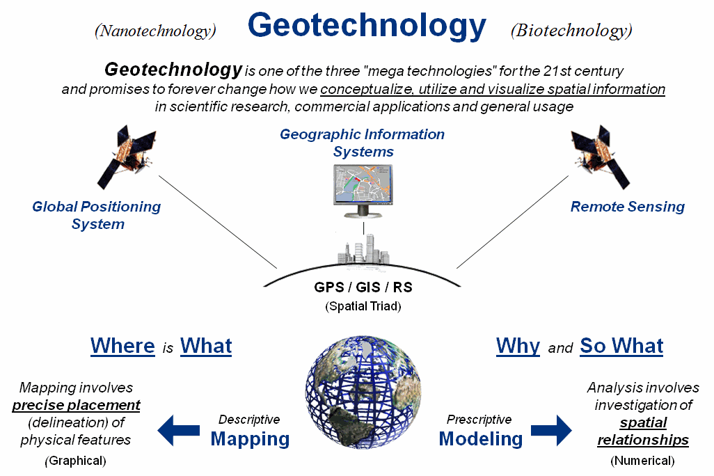
Figure 1. Conceptual
framework of Geotechnology.
The Wikipedia defines Biotechnology as “any technological
application that uses biological systems, living organisms, or derivations
thereof, to make or modify products or processes for specific use,” and Nanotechnology
as “a field whose theme is the control of matter on and atomic and molecular
scale.” By any measure these are
sweeping definitions that encompass a multitude of sub-disciplines, conceptual
approaches and paradigms. Figure 1
suggests a similar sweeping conceptualization for Geotechnology.
The top portion of the figure relates Geotechnology
to “spatial information” in a broad stroke similar to biotechnology’s use of
“biological systems” and nanotechnology’s use of “control of matter.” The middle portion identifies the three
related technologies for mapping features on the surface of the earth— GPS, GIS
and RS. The bottom portion identifies
the two dominant application arenas that emphasize descriptive Mapping (Where
is What) and prescriptive Modeling (Why
and So What).
What is most important to keep in mind is that
geotechnology, like bio- and nanotechnology, is greater than the sum of its
parts—GPS, GIS and RS. While these
individual mapping technologies provide the enabling capabilities, it is the
application environments themselves that propel geotechnology to mega status. For example, precision agriculture couples
the spatial triad with robotics to completely change crop production. Similarly, coupling “computer agents” with
the spatial triad produces an interactive system that has radically altered
marketing and advertising through spatially-specific queries and displayed
results. Or coupling immersive
photography with the spatial triad to generate an entirely type of “street
view” map that drastically changes 8,000 years of analog mapping.
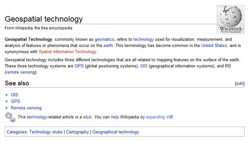
Figure 2. Wikipedia
Definition of Geospatial Technology.
To this point in our technology’s short four
decade evolution it has been repeatedly defined from within. The current “geospatial
technology” moniker focuses on the interworking parts that resonates with GIS
specialists (see figure 2).
However to the uninitiated, the term is as off-putting as it is
confusing—geo (Latin for the earth), spatial (pertaining to
space), technology (application of science). Heck, it even sounds
redundant and is almost as introvertedly-cute as the
terms geomatics and map-ematics.
On the other hand, the use of the emerging
term “Geotechnology” for the first time provides an opportunity to craft a
definition with a broader perspective that embraces the universality of its
application environments and societal impacts along the lines of the bio- and
nanotechnology.
As a draft attempt, let me suggest—
Geotechnology refers to any
technological application that utilizes spatial location in visualizing,
measuring, storing, retrieving, mapping and analyzing features or phenomena
that occur on, below or above the earth.
It is recognized by the U.S. Department of Labor as one of the “three
mega-technologies for the 21st Century,” along with Biotechnology
and Nanotechnology. There are three
primary mapping technologies that enable geotechnology— GPS (Global Positioning
System), GIS (Geographic Information Systems) and RS (Remote Sensing). …etcetera, etcetera, etcetera… to quote a famous King of Siam.
As with any controversial endeavor, the devil is in the details (the etcetera). One of the biggest problems with the term is
that geology staked the flag several years ago with its definition of
geotechnology as “the application of the methods of engineering and science to
exploitation of natural resources” (yes, they use the politically incorrect
term “exploitation”). Also, there is an
International Society for Environmental Geotechnology, as well as a several
books with the term embedded in their titles.
On the bright side, the Wikipedia doesn’t have an entry for
Geotechnology. Nor is the shortened term
“geo” exclusive to geology; in fact just the opposite, as geography is most
frequently associated with the term (geo + graph + y
literally means “to write the descriptive science dealing with the surface
of the earth”). Finally, there are
other disciplines, application users and the general public that are desperate
for an encompassing term and succinct definition of our field that doesn’t
leave them tongue-tied, shaking their heads in dismay or otherwise
dumbfounded.
Such is the byzantine fodder of academics …any inspired souls out there
willing to take on the challenge of evolving/expanding the definition of
Geotechnology, as well as the perspective of our GPS/GIS/RS enabled mapping
technology?
_____________________________
Author’s Notes: see www.nature.com/nature/journal/v427/n6972/full/nj6972-376a.html
for an article in Nature (427, 376-377; January 22, 2004) that identifies Geotechnology by the US Department
of Labor as one of the three "mega technologies for the 21st century” (the
other two are Nanotechnology and Biotechnology).